Advancetown, Queensland facts for kids
Quick facts for kids AdvancetownCity of Gold Coast, Queensland |
|||||||||||||||
|---|---|---|---|---|---|---|---|---|---|---|---|---|---|---|---|

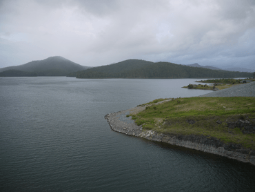
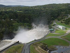
Hinze Dam after the 3rd Stage completion
|
|||||||||||||||
| Population | 528 (2021 census) | ||||||||||||||
| • Density | 8.302/km2 (21.50/sq mi) | ||||||||||||||
| Postcode(s) | 4211 | ||||||||||||||
| Area | 63.6 km2 (24.6 sq mi) | ||||||||||||||
| Time zone | AEST (UTC+10:00) | ||||||||||||||
| Location |
|
||||||||||||||
| LGA(s) | City of Gold Coast | ||||||||||||||
| State electorate(s) | Mudgeeraba | ||||||||||||||
| Federal Division(s) | |||||||||||||||
|
|||||||||||||||
Advancetown is a quiet, rural area located in the City of Gold Coast, Queensland, Australia. It's a "locality," which is like a small district or neighborhood. In 2021, about 528 people called Advancetown home.
Contents
Exploring Advancetown's Landscape
Advancetown is nestled in the Gold Coast hinterland, which means it's in the hilly and mountainous area behind the famous Gold Coast beaches. This landscape was perfect for building the Hinze Dam.
Hinze Dam and Advancetown Lake
The Hinze Dam is a huge wall that holds back the water of the Nerang River and Little Nerang Creek. This creates a large body of water called Advancetown Lake. This lake is super important because it provides drinking water for most of the Gold Coast region.
Mountains and Rivers
Advancetown has two main mountains:
- Mudgeeraba, which is about 240 meters (787 feet) high.
- Pages Pinnacle, which is taller at about 398 meters (1,306 feet) high.
The northern part of Advancetown, located downstream from the dam, is flatter. Here, you'll find a mix of homes and rural areas where animals like goats might graze. A well-known spot here is Latimers Crossing, where you can cross the Nerang River.
The main road, Nerang–Murwillumbah Road (State Route 97), runs right through Advancetown from north to south.
Advancetown's Past
Advancetown has an interesting history, starting with its name and early settlers.
How Names Were Chosen
The mountain Mudgeeraba got its name from the local Aboriginal Bundjalung language. Mudherri means sticky, and ba means place, so it means a "muddy place." Pages Pinnacle was named after a local landowner, Sir Earle Christmas Grafton Page.
Early Days: Timber and Bullock Teams
In the 1870s, people came to Advancetown for its rich supply of good quality timber. David Yuan set up a saw mill in 1881, and more people started to settle here. It became a resting spot for "bullock teams" – groups of oxen that pulled heavy loads of timber to the railway in Nerang. Even in the 1930s, there were still many bullock teams working in the area.
Hotels and Schools
The first hotel, the Beechmont Hotel, was built in 1884. Later, in 1905, Ernest Belliss opened the Advancetown Hotel. He even gave land for the Advancetown school, which helped the name "Advancetown" stick. The original hotel burned down in 1933, but a new one was built the next year.
Advancetown State School opened in 1909. It closed a few times over the years before closing for good in 1960.
The Story of Hinze Dam
The Hinze Dam was first finished in 1976. It was named after Carl and Johanna Hinze, who were pioneers in the valley that was flooded to create the dam. When the dam was built, the original settlement of Advancetown, including the school, was covered by water. For a short time, the area's name was changed to "Latimer" in 1979, but it was changed back to Advancetown in 1985.
The dam was made bigger in 1989 and again in 2011 to hold even more water. The last expansion in 2011 cost about $395 million!
Advancetown Today
Advancetown used to be part of the Shire of Albert. In 1995, it became part of the larger City of Gold Coast.
How Many People Live Here?
The number of people living in Advancetown has grown over the years:
- In 2011, there were 352 people.
- In 2016, the population grew to 482 people.
- By 2021, 528 people lived in Advancetown.
Special Places to See
Advancetown has a few places that are important to its history and heritage.
Avenue of Commemorative Trees
One special place is the Avenue of Commemorative Trees, located on Latimers Crossing Road. This avenue is listed on the Gold Coast Local Heritage Register, meaning it's a protected historical site.
Learning in Advancetown
There are no schools directly in Advancetown. Students usually go to schools in nearby areas. The closest primary schools are Nerang State School and Gilston State School. For high school, students attend Nerang State High School.
Sports and Fun
Advancetown is home to a famous golf course and offers many outdoor activities.
The Grand Golf Club
While the entrance to The Grand Golf Club is in Gilston, most of its golf course is actually in Advancetown. This private club has a 19-hole golf course designed by the famous golfer Greg Norman.
Activities at Hinze Dam
The Hinze Dam is a great place for visitors!
- There's a visitor center with educational displays, a cafe, and picnic areas.
- Below the dam's spillway, you'll find more picnic spots with barbecues.
- If you love biking, there's a network of special mountain bike trails across the spillway.
- You can also enjoy non-motorized boating and fishing (catch-and-release only) in the lake from two boat ramps.
- There are also many walking trails to explore.
Advancetown's Weather
Advancetown has a humid subtropical climate, which means it has warm, wet summers and mild winters. There's a weather station at Hinze Dam that has been keeping records since 1974.
| Climate data for Hinze Dam | |||||||||||||
|---|---|---|---|---|---|---|---|---|---|---|---|---|---|
| Month | Jan | Feb | Mar | Apr | May | Jun | Jul | Aug | Sep | Oct | Nov | Dec | Year |
| Record high °C (°F) | 40.9 (105.6) |
40.6 (105.1) |
36.5 (97.7) |
34.5 (94.1) |
32.2 (90.0) |
27.0 (80.6) |
27.3 (81.1) |
34.5 (94.1) |
35.6 (96.1) |
38.3 (100.9) |
39.9 (103.8) |
39.7 (103.5) |
40.9 (105.6) |
| Mean daily maximum °C (°F) | 29.1 (84.4) |
28.8 (83.8) |
27.7 (81.9) |
25.7 (78.3) |
23.2 (73.8) |
21.0 (69.8) |
20.8 (69.4) |
22.2 (72.0) |
25.0 (77.0) |
26.4 (79.5) |
27.3 (81.1) |
28.8 (83.8) |
29.1 (84.4) |
| Mean daily minimum °C (°F) | 20.2 (68.4) |
20.5 (68.9) |
19.2 (66.6) |
16.8 (62.2) |
13.8 (56.8) |
11.6 (52.9) |
10.2 (50.4) |
10.6 (51.1) |
13.3 (55.9) |
15.5 (59.9) |
17.4 (63.3) |
19.2 (66.6) |
10.2 (50.4) |
| Record low °C (°F) | 11.8 (53.2) |
15.5 (59.9) |
13.8 (56.8) |
9.5 (49.1) |
5.9 (42.6) |
5.1 (41.2) |
2.8 (37.0) |
4.7 (40.5) |
7.0 (44.6) |
8.1 (46.6) |
9.9 (49.8) |
12.3 (54.1) |
2.8 (37.0) |
| Average precipitation mm (inches) | 182.7 (7.19) |
193.6 (7.62) |
164.2 (6.46) |
117.8 (4.64) |
125.3 (4.93) |
83.1 (3.27) |
51.2 (2.02) |
45.1 (1.78) |
42.1 (1.66) |
84.4 (3.32) |
117.7 (4.63) |
157.7 (6.21) |
1,369.9 (53.93) |
| Average precipitation days | 12.9 | 13.3 | 13.6 | 10.0 | 9.8 | 6.9 | 6.4 | 5.5 | 6.2 | 9.1 | 10.8 | 12.2 | 116.7 |
| Source: Bureau of Meteorology | |||||||||||||
 | Madam C. J. Walker |
 | Janet Emerson Bashen |
 | Annie Turnbo Malone |
 | Maggie L. Walker |


