Clagiraba, Queensland facts for kids
Quick facts for kids ClagirabaGold Coast, Queensland |
|||||||||||||||
|---|---|---|---|---|---|---|---|---|---|---|---|---|---|---|---|

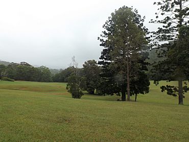
Little Clagiraba Reserve, 2016
|
|||||||||||||||
| Population | 651 (2021 census) | ||||||||||||||
| • Density | 23.42/km2 (60.7/sq mi) | ||||||||||||||
| Postcode(s) | 4211 | ||||||||||||||
| Area | 27.8 km2 (10.7 sq mi) | ||||||||||||||
| Time zone | AEST (UTC+10:00) | ||||||||||||||
| Location |
|
||||||||||||||
| LGA(s) | City of Gold Coast | ||||||||||||||
| State electorate(s) |
|
||||||||||||||
| Federal Division(s) | Forde | ||||||||||||||
|
|||||||||||||||
Clagiraba is a quiet, rural area located in the City of Gold Coast, Queensland, Australia. It's a peaceful countryside spot where about 651 people live, according to the 2021 census.
Contents
Where is Clagiraba?
Clagiraba is about 25 kilometers (15 miles) west of the famous Surfers Paradise. It's nestled in the 'hinterland' of the Gold Coast. This means it's away from the busy coast and more in the countryside. You can find it between places like Mount Nathan and Witheren. It also touches the southern part of Tamborine Mountain, a beautiful area known for its nature.
Two main roads help people get around this area. These are the Beaudesert-Nerang Road (also called State Route 90) and the Nerang–Murwillumbah Road (State Route 97).
The Story Behind the Name
The name Clagiraba comes from Clagiraba Creek, which flows into the Coomera River. The name itself has a special meaning. It comes from the Indigenous name 'Kalagareebah'. This means 'young or single men's ground'. Long ago, this was a significant place where young Indigenous men would go for important ceremonies.
Who Lives in Clagiraba?
The number of people living in Clagiraba has slowly grown over the years.
- In 2011, about 561 people lived here.
- By 2016, the population grew to 601 people.
- In 2021, the latest count showed 651 people called Clagiraba home.
Learning and Schools
There are no schools directly in Clagiraba. However, students can easily go to schools in nearby towns.
Primary Schools Nearby
- St Bernard State School is in Tamborine Mountain to the north-west.
- Gaven State School is in Oxenford to the north-east.
- Nerang State School is in Nerang to the east.
- Gilston State School is in Gilston to the south-east.
- Canungra State School is in Canungra to the south-west.
High Schools Nearby
- Mount Tamborine State High School is in Tamborine Mountain to the north-west.
- Pacific Pines State High School is in Pacific Pines to the north-east.
- Nerang State High School is in Nerang to the east.
Parks and Fun Places
Clagiraba has several parks where people can enjoy nature and relax.
- Clagiraba Road Causeway Reserves
- Coolbunbin Creek Reserve
- Freeman Family Park
- Henri Robert Drive Reserve
- Heritage Drive Reserve
- King Parrot Reserve
- Little Clagiraba Reserve
- Lower Beechmont Conservation Area
- Mango Tree Park
- Scenic Reserve
- Stewart Road Parklands
Important Facilities
The Clagiraba Rural Fire Station is an important facility in the area. It is located at 177 Clagiraba Road, close to Little Clagiraba Reserve. This station helps keep the community safe from fires.
 | Leon Lynch |
 | Milton P. Webster |
 | Ferdinand Smith |


