
Coomera River facts for kids
Quick facts for kids Coomera |
|
|---|---|

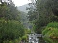
Upper reaches of the Coomera River in Lamington National Park
|
|

Location of Coomera River river mouth in Queensland
|
|
| Country | Australia |
| State | Queensland |
| Region | South East Queensland |
| Local government areas | Scenic Rim Region, City of Gold Coast |
| Physical characteristics | |
| Main source | McPherson Range, Great Dividing Range Binna Burra 524 m (1,719 ft) 28°13′3″S 153°11′9″E / 28.21750°S 153.18583°E |
| River mouth | Gold Coast Broadwater Coomera (north branch), Paradise Point (south branch) 0 m (0 ft) 27°51′58″S 153°24′21″E / 27.86611°S 153.40583°E |
| Length | 80 km (50 mi) |
| Basin features | |
| Basin size | 489 km2 (189 sq mi) |
| Tributaries |
|
| National park | Lamington National Park |
The Coomera River is a beautiful river in the southeast part of Queensland, Australia. It flows through the Gold Coast and Scenic Rim Region areas. The river's water comes from a large area of land called a "catchment," which is about 489 square kilometers.
Contents
Where Does the River Flow?
The Coomera River starts high up in Lamington National Park, near a place called Binna Burra. It begins its journey by falling over the amazing Coomera Falls in the Coomera Gorge.
As the river flows, it goes through big farms and then past many homes and buildings, especially closer to the ocean. Ten smaller streams, called tributaries, join the Coomera River along its way.
Near the end of its journey, the river splits into two main parts. One part, called the North Branch, flows around Coomera Island and heads towards the Pimpama River. The main part of the river flows south of Coomera Island, passing places like the Sovereign Islands and Hope Island.
The river also flows around Foxwell Island further upstream. It eventually reaches the northern tip of the Gold Coast Broadwater at Paradise Point. The Coomera River drops 524 meters from its source to the ocean over its 80-kilometer length.
River Life and Activities
The Coomera River's catchment area is 489 square kilometers. The river itself is about 80 kilometers long. In its freshwater parts, the river is usually up to 1.5 meters deep. However, in some waterholes and below waterfalls, it can be deeper than 2 meters.
The lower part of the river, near the ocean, is a fast-growing area with many homes. Places like Sanctuary Cove and Santa Barbara are becoming popular places to live.
The upper tidal areas of the river are great for waterskiing and wakeboarding. The upper Coomera River is also home to 18 important animal species, including the amazing platypus.
You can cross the river using the Pacific Motorway and the Gold Coast railway line between Upper Coomera and Oxenford. There are also many other road crossings further upstream.
How Did the Coomera River Get Its Name?
In May 1827, Patrick Logan was the first non-Indigenous person to find the Coomera River. It was first named the "River Arrowsmith" by a government surveyor named Robert Dixon. He named it after a company in London that made maps.
However, Thomas Mitchell, who was the main surveyor for the colony, decided to change many of these names to Aboriginal names. This is how the river got its current name.
The name Coomera comes from a word in the Bundjalung language (specifically the Ngaraangbal dialect). The word kumera refers to a type of wattle tree. The bark from this tree was used by Indigenous people to stun fish, making them easier to catch.
Images for kids
-
The Coomera River flowing through Clagiraba in 2016.

