Chevron Island facts for kids

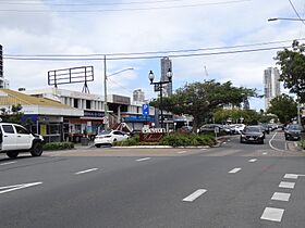
Chevon Island CBD, 2023.
|
|

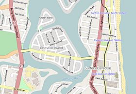
Chevron Island in OpenStreetMap, 2015
|
|
| Geography | |
|---|---|
| Location | Nerang River |
| Total islands | 2 |
| Major islands | Chevron; Cronin |
| Highest elevation | 2 m (7 ft) |
| Administration | |
| State | Queensland |
| Region | Gold Coast, South East Qld |
| Largest settlement | Surfers Paradise |
Chevron Island is a cool urban island in the Nerang River. It's a lively part of Surfers Paradise, a famous suburb in the City of Gold Coast, Queensland, Australia.
Contents
Discovering Chevron Island's Past
Chevron Island has a really interesting history. It wasn't always called Chevron Island. Long ago, it was known as Goat Island.
Why Was It Called Goat Island?
Goat Island got its name because it used to be a cattle farm. This farm had a lot of goats living there! The goats helped keep the tough plants from growing too wild. After the farm was sold, the goats moved on. No one knows what happened to them after that.
How Chevron Island Was Formed
Many islands on the Gold Coast are man-made. They were created by adding sand and dirt to the water. This process is called land reclamation. But Chevron Island was different. It was a natural island that already existed.
However, its shape and height were changed. In the 1950s, more sand was added to the island. It was also separated from where the HOTA (Home of the Arts) building is today.
River Changes and Development
The Nerang River used to be very wide and shallow. It had many sandbanks that would shift around. To make the river better for boats, people started dredging. This means they dug out deeper channels in the river.
The sand and dirt they dug up were used for something important. They helped create new islands where people could live. This also made the riverbanks stronger. All these changes helped the area grow with new homes and businesses.
Chevron Island also had a special spot for a barge or ferry. This ferry would cross the Nerang River to Cavill Avenue.
Exploring Chevron Island's Location
Chevron Island is a busy place with lots of homes. It's connected to other areas by two bridges.
Connecting Bridges
One bridge links Chevron Island to Southport and Bundall, which are to the west. The other bridge connects it to the coastal area of Surfers Paradise, to the east. A road called Thomas Drive goes right through the island. It connects Slatyer Road in Southport/Bundall to Elkhorn Avenue in Surfers Paradise.
Island Height
The island is about 2 meters (6.5 feet) above sea level. This measurement is taken at the average high tide mark.
Meet Cronin Island
Close to Chevron Island is a smaller island called Cronin Island. You can get to Cronin Island from Chevron Island. It's also located in the Nerang River. Cronin Island is named after Jack Cronin. He was the first engineer to work for the Southport Town Council. This council is now known as the Gold Coast City Council.
 | DeHart Hubbard |
 | Wilma Rudolph |
 | Jesse Owens |
 | Jackie Joyner-Kersee |
 | Major Taylor |

