Molendinar, Queensland facts for kids
Quick facts for kids MolendinarGold Coast, Queensland |
|||||||||||||||
|---|---|---|---|---|---|---|---|---|---|---|---|---|---|---|---|

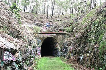
Ernest Junction railway tunnel, eastern portal, 2019
|
|||||||||||||||
| Population | 6,450 (2021 census) | ||||||||||||||
| • Density | 838/km2 (2,170/sq mi) | ||||||||||||||
| Postcode(s) | 4214 | ||||||||||||||
| Area | 7.7 km2 (3.0 sq mi) | ||||||||||||||
| Time zone | AEST (UTC+10:00) | ||||||||||||||
| Location |
|
||||||||||||||
| LGA(s) | City of Gold Coast | ||||||||||||||
| State electorate(s) | Southport | ||||||||||||||
| Federal Division(s) | Moncrieff | ||||||||||||||
|
|||||||||||||||
Molendinar is a suburb located on the beautiful Gold Coast in Queensland, Australia. It's a place where you'll find both homes and businesses. In 2021, about 6,450 people lived in Molendinar.
Contents
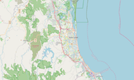
Where is Molendinar?
Molendinar is surrounded by major roads. To the north, you'll find the Smith Street Motorway. Olsen Avenue is to the east, and the Southport Nerang Road is to the south. The Pacific Motorway forms its western boundary. This suburb has a mix of areas for living and areas for industries and businesses.
A Look Back in Time
How Molendinar Got Its Name
The original Aboriginal name for this area was Jerringan. This name means "stringybark tree".
The suburb's current name, Molendinar, comes from an old railway station. This station was part of the South Coast railway line, which operated from 1889 to 1964. The railway station itself was named after a farm. This farm belonged to George Hope, who named it after a stream called Molendinar Burn in Glasgow, Scotland. There was also another old railway station called Ernest Junction railway station nearby.
Changing Names and Growth
In the 1960s, this area was known as Silver Bridle. Molendinar later included a suburb called Ernest. Ernest was renamed Parkwood in 1989. However, parts of Molendinar's industrial area were still known as Ernest until 2003.
The Molendinar Industrial Estate is a large area for businesses. It was a project supported by the Queensland Government and the Gold Coast City Council. Development of this area began in 1969.
Schools and Community
Trinity Lutheran Primary School first opened its doors on 27 January 1981. It was located in Ashmore. Trinity Lutheran College, a secondary school, started on 28 January 1987 in Molendinar. In 2002, these two schools joined together. They became Trinity Lutheran College, offering both primary and secondary education. The college now operates across two campuses.
The Lynne Richardson Community Centre is a local meeting place. It was officially opened by the Gold Coast City Council on 2 April 2012.
Who Lives in Molendinar?
The number of people living in Molendinar has grown over the years.
- In 2011, there were 6,375 people.
- In 2016, the population was still 6,375 people. The average age of people in Molendinar was 36 years old.
- By 2021, the population had increased to 6,450 people.
Education in Molendinar
Trinity Lutheran College is a private school for both boys and girls. It has a primary campus (Prep to Year 5) located at 641 Ashmore Road. In 2017, the school had over 1,000 students.
Molendinar does not have any government schools within its boundaries. Students usually attend nearby government schools.
- The closest government primary schools are Ashmore State School in Ashmore or Nerang State School in Nerang.
- For secondary school, students can go to Keebra Park State High School in Southport or Nerang State High School in Nerang.
Community Facilities
The Lynne Richardson Community Centre is an important local facility. It is located at 2A Gidgee Court. This centre provides a space for community activities and events.
Images for kids
 | Aaron Henry |
 | T. R. M. Howard |
 | Jesse Jackson |


