
Molendinar Burn facts for kids
Quick facts for kids Molendinar Burn |
|
|---|---|
.jpg)
Molendinar Burn at Stepps
|
|
| Country | Scotland |
| City | Glasgow |
| Physical characteristics | |
| Main source | Frankfield Loch in Glasgow Cardowan, Glasgow, Scotland, United Kingdom 82 m (269 ft) 55°53′04.8″N 4°09′05.5″W / 55.884667°N 4.151528°W |
| River mouth | Flows into the River Clyde Glasgow Green, Glasgow, Scotland, United Kingdom 0 m (0 ft) 55°51′08.9″N 4°14′44.8″W / 55.852472°N 4.245778°W |
| Length | 7 km (4.3 mi) (approx.) |
The Molendinar Burn is a small stream or burn located in Glasgow, Scotland. It's a very important part of Glasgow's history! This little burn was where the city of Glasgow first began.
Around the 6th century, St Mungo founded his church right by this burn. The area was originally called Mellingdenor. Later, as Glasgow grew, the burn was used to power many mills. This is why its name changed to "Molendinar," which means "relating to a mill or millers." It's possible the original Welsh name Mellingdenor also had a similar meaning.
The Molendinar Burn: A Look Back in Time
In the late 1700s, the Molendinar Burn looked very different. Most of it flowed openly above ground. Maps from that time show its path clearly.
Its source was a small loch called "Huggenfield" (now Hoggansfield Loch). The burn then flowed southwest. It passed through quiet, undeveloped areas like Blackhill. It even went under the Monkland Canal.
As it got closer to the city, it turned south. It flowed past the old Kirk (church). It followed the path of what is now Wishart Street. The burn then passed under busy streets like Duke Street and Gallowgate. It flowed in front of St Andrew's Church. Back then, it entered the River Clyde near what is now Clyde Street.
The Molendinar Burn: Today's Path
Today, the Molendinar Burn still flows, but much of it is hidden. Its current source is Frankfield Loch in Cardowan. This loch wasn't on maps in the 1700s. A short, man-made channel connects Frankfield Loch to Hogganfield Loch.
The path from Hoggansfield Loch to the River Clyde is similar to its old route. However, since the 1870s, most of the burn has been put into underground pipes. This process is called "culverting."
You can still see short parts of the burn above ground. One place is in Molendinar Park, in the Blackhill area. Another spot is near the old Great Eastern Hotel on Duke Street.
The very last part of the burn, about 250 meters, was rerouted a while ago. Now, it enters the Clyde a bit further upstream than it did in 1795. It flows into the Clyde near the Tidal Weir.
Molendinar Burn Photo Gallery
- Molendinar Burn Photo Gallery
-
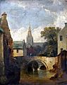
Molendinar Burn by Elizabeth Walker c1850
-
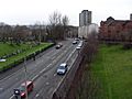
Wishart Street, built on top of the culvert carrying the Molendinar Burn near Glasgow Cathedral
-
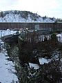
Molendinar Burn at Duke Street
-
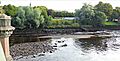
The culverted Molendinar Burn entering the Clyde at Glasgow Green(2020)
03b.jpg)

.jpg)

