Bonogin, Queensland facts for kids
Quick facts for kids BonoginGold Coast, Queensland |
|||||||||||||||
|---|---|---|---|---|---|---|---|---|---|---|---|---|---|---|---|

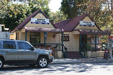
Bonogin General Store, 2012
|
|||||||||||||||
| Population | 4,896 (2021 census) | ||||||||||||||
| • Density | 126.51/km2 (327.7/sq mi) | ||||||||||||||
| Postcode(s) | 4213 | ||||||||||||||
| Area | 38.7 km2 (14.9 sq mi) | ||||||||||||||
| Time zone | AEST (UTC+10:00) | ||||||||||||||
| Location |
|
||||||||||||||
| LGA(s) | City of Gold Coast | ||||||||||||||
| State electorate(s) | Mudgeeraba | ||||||||||||||
| Federal Division(s) | |||||||||||||||
|
|||||||||||||||
Bonogin is a quiet, rural area located in the City of Gold Coast, Queensland, Australia. It's known for its natural beauty and peaceful surroundings. In 2021, about 4,896 people called Bonogin home.
Contents
Where is Bonogin Located?
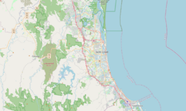
Bonogin is found on the edge of the Gold Coast hinterland. This is a beautiful, hilly area behind the famous Gold Coast beaches. Bonogin is about 81 kilometers (50 miles) away from Brisbane, the capital city of Queensland.
What's the Story Behind Bonogin's Name?
The exact meaning of the name "Bonogin" isn't fully known. However, some people think it comes from an Aboriginal word, Boonoo. This word means red bloodwood, which is a type of tree.
Early Days and Farming
European settlers started arriving in Bonogin in the 1870s. At first, they worked in the timber industry, cutting down trees. Later, they focused on dairying, which means farming cows for milk. After that, some farmers began growing bananas.
The Bonogin Creek School
In 1913, a school called Bonogin Creek State School opened its doors on July 7. It was located on Bonogin Road. The school had to close a few times because there weren't enough teachers. It finally closed for good on March 30, 1924. The school building was later moved to another place called Wunburra in 1934.
Modern Bonogin
In the 1980s, some of the larger farms in Bonogin were divided into smaller blocks of land. These became residential areas where people could build homes with lots of space.
How Many People Live in Bonogin?
The number of people living in Bonogin has grown over the years:
- In 2011, there were 4,182 people.
- In 2016, the population grew to 4,573 people.
- By 2021, Bonogin had a population of 4,896 people.
Where Do Kids in Bonogin Go to School?
Bonogin itself doesn't have any schools. Students usually go to nearby areas for their education.
- For primary school, the closest government schools are Mudgeeraba Creek State School and Clover Hill State School. Both are in Mudgeeraba, which is just to the north.
- For high school, the nearest government secondary school is Robina State High School in Robina, also to the north.
Exploring Bonogin Creek
Bonogin Creek is an important natural feature in the area. It's part of a special program by the Gold Coast City Council called "Beaches to Bushland." This program helps volunteers restore and protect natural areas.
The main part of Bonogin Creek starts in the Gold Coast hinterland. In 1999, a group was formed to help protect the local plants and restore the creek's natural habitat. Davenport Park is a park along the lower part of the creek in Bonogin. In 2013, another group, the Bonogin Valley bushcare group, started helping to restore this park and creek area.
What Amenities Does Bonogin Have?
The Gold Coast City Council provides a mobile library service for the community. This library on wheels visits Davenport Park on Bonogin Road East every two weeks, bringing books and resources to the residents.
 | James Van Der Zee |
 | Alma Thomas |
 | Ellis Wilson |
 | Margaret Taylor-Burroughs |


