
Currumbin Valley, Queensland facts for kids
Quick facts for kids Currumbin ValleyGold Coast City, Queensland |
|||||||||||||||
|---|---|---|---|---|---|---|---|---|---|---|---|---|---|---|---|

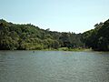
Currumbin Creek at Robert Neumann Park, 2015
|
|||||||||||||||

Currumbin Valley
Location in Queensland
|
|||||||||||||||
| Population | 2,084 (2021 census) | ||||||||||||||
| • Density | 59.54/km2 (154.2/sq mi) | ||||||||||||||
| Postcode(s) | 4223 | ||||||||||||||
| Elevation | 15 m (49 ft) | ||||||||||||||
| Area | 35.0 km2 (13.5 sq mi) | ||||||||||||||
| Time zone | AEST (UTC+10:00) | ||||||||||||||
| Location |
|
||||||||||||||
| LGA(s) | City of Gold Coast | ||||||||||||||
| State electorate(s) | Currumbin | ||||||||||||||
| Federal Division(s) | McPherson | ||||||||||||||
|
|||||||||||||||
Currumbin Valley is a beautiful rural area in Queensland, Australia. It's part of the City of Gold Coast and sits right next to the border of New South Wales. In 2021, about 2,084 people called Currumbin Valley home.
Contents
Exploring Currumbin Valley

Currumbin Valley is located in the Gold Coast hinterland. This means it's in the green, hilly area behind the famous Gold Coast beaches. Its southern edge touches the border with New South Wales.
The valley is about 24 kilometers long and 4 kilometers wide. It has both rural areas and places where people live. Most of the land is rural, meaning it's used for farming or is natural bushland. Currumbin Valley is special because it's the first valley north of the "Green Cauldron" escarpment. This area is known for its amazing natural beauty.
The main road, Currumbin Creek Road, goes 20 kilometers west. It ends at the Mt Cougal Section of Springbrook National Park. Here, you can find a World-Heritage-Listed rainforest walk. There are also beautiful waterfalls called the Cougal Cascades. You'll see lots of native plants and animals. This rainforest is part of the ancient Gondwana Rainforests of Australia.
A Look Back in Time
The Currumbin Valley area was first used for cutting timber and raising animals. People started settling here in the 1840s.
In the 1870s and 1880s, many farms began to appear. Farmers grew bananas and sugar, and they also had dairy farms. This helped the small population grow.
More growth happened in the early 1900s when a railway line was built.
Currumbin Upper Provisional School opened its doors on September 21, 1908. It became Currumbin State School in 1909. The school closed for a short time in the 1920s due to low student numbers. In 1966, it was renamed Currumbin Valley State School.
In 1926, people decided to build a church. A man named John Boyd gave the land. A retired builder, Alexander Mayes, designed the church and watched over its construction. The Upper Currumbin Presbyterian Church opened on April 23, 1927. Later, in 1977, it became the Currumbin Valley Uniting Church. Today, it's known as the Currumbin Valley Community Church.
The area saw a lot of new buildings and growth starting in the 1970s. Even more growth happened in the 1990s as more homes were built.
However, the growth slowed down between 2001 and 2011. Fewer new homes were added during this time.
Who Lives Here?
In 2016, Currumbin Valley had 1,849 people living there. By 2021, the population had grown to 2,084 people.
Learning in the Valley
Currumbin Valley State School is a primary school for kids from Preparatory to Year 6. It's located at 1223 Currumbin Creek Road. In 2018, the school had 171 students.
There are no high schools directly in Currumbin Valley. The closest government high school is Elanora State High School. It's in Elanora, which is a nearby suburb to the north.
Things to Do and See

The Currumbin Valley Rock Pool is a very popular spot for locals. It's about 12 kilometers inland from Currumbin beach. It's a great place to cool off and have fun!
Springbrook also has many walking trails through the rainforest. You can find out more about these trails at the Rangers offices in Natural Bridge or Springbrook.
Nicoll Scrub National Park is another protected area in Queensland. It's about 88 kilometers southeast of Brisbane. This park is next to the Currumbin Valley Reserve. It helps protect the remaining rainforest plants in the area.
Images for kids
-
Currumbin Creek at Robert Neumann Park, 2015
