Coolangatta facts for kids
Quick facts for kids CoolangattaGold Coast, Queensland |
|||||||||||||||
|---|---|---|---|---|---|---|---|---|---|---|---|---|---|---|---|
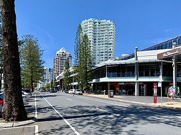
Marine Parade
|
|||||||||||||||
| Population | 6,491 (2021 census) | ||||||||||||||
| • Density | 3,610/km2 (9,300/sq mi) | ||||||||||||||
| Established | 1883 | ||||||||||||||
| Postcode(s) | 4225 | ||||||||||||||
| Elevation | 6 m (20 ft) | ||||||||||||||
| Area | 1.8 km2 (0.7 sq mi) | ||||||||||||||
| Time zone | AEST (UTC+10:00) | ||||||||||||||
| Location |
|
||||||||||||||
| LGA(s) | City of Gold Coast | ||||||||||||||
| State electorate(s) | Currumbin | ||||||||||||||
| Federal Division(s) | McPherson | ||||||||||||||
|
|||||||||||||||
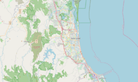
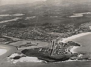
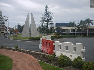
Coolangatta is a sunny coastal suburb in Queensland, Australia. It is part of the City of Gold Coast. This area is the Gold Coast's most southern suburb. It shares a border with New South Wales. In 2021, about 6,491 people lived in Coolangatta.
Contents
Coolangatta's Past
Coolangatta is on the traditional land of the Aboriginal Bundjalung people. The Yugambeh people are the local caretakers of this land. Their language, Yugambeh, is one of the Australian Aboriginal languages. It is spoken in areas like the Gold Coast and Tweed River Valley.
How Coolangatta Began
Coolangatta was one of the first places settled on the Gold Coast. Europeans arrived here around 1828. They set up a convict station and started cutting down red cedar trees.
The Shipwreck of the Coolangatta
The town got its name from a shipwreck! On August 18, 1846, a ship called the Coolangatta was wrecked. It happened near Kirra Beach during a big storm.
The Coolangatta was a large schooner, about 25 meters long. It was built in 1843. The ship was carrying two prisoners and was going to pick up red cedar logs.
Captain Steele was ashore when a strong gale hit. The ship's anchors broke, and it washed onto the beach. Everyone on board swam to safety. The survivors then walked 113 kilometers north. Friendly indigenous Australians helped them along the way.
Growing into a Town
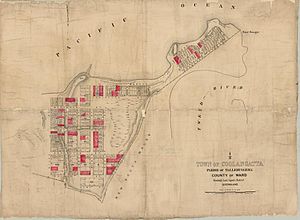
After the shipwreck, more people settled in the area in the 1860s. A small community started to grow. In 1883, the area was surveyed for a town.
Henry Schneider, a government surveyor, named the town Coolangatta. He named it after the shipwreck. This happened in 1883, before a big land sale in 1884.
Because Coolangatta was a border town, it had a customs office. It also had a boatshed and a government wharf.
The 1900s in Coolangatta
The railway line reached Tweed Heads in 1903. This helped Coolangatta become a popular holiday town. It grew quickly after that.
The Tweed Heads Surf and Life Saving Club started in 1909. Its building opened in 1911. More hotels and guesthouses were built. A shopping area also developed.
Coolangatta had its own local government from 1914. But in 1949, it joined the Town of South Coast. This later became the City of Gold Coast.
Newspapers like the Coolangatta Star were published here. They told local news from 1916 to 1927.
The 1919 Border Closure
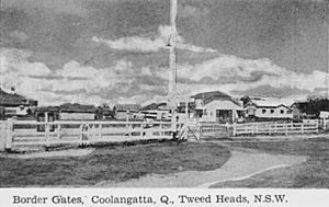
In January 1919, the border between Queensland and New South Wales closed. This was to stop the 1918 flu pandemic from spreading. Many people were stuck on one side of the border.
Coolangatta had no doctor, pharmacist, or butcher at the time. It also had no school or post office. Services had to be duplicated on the Queensland side.
Fifty-six children from Coolangatta went to school in Tweed Heads. When the border closed, they couldn't go. So, a temporary school opened in Coolangatta. It was in the town council's meeting room. The Queensland Department of Public Instruction sent a teacher.
A new school building was then built. Coolangatta State School officially opened in 1920. It later moved to a new location in 1977.
Churches and Schools
Many churches were built in Coolangatta. The Methodist Memorial Church opened in 1924. It later became the Coolangatta Uniting Church.
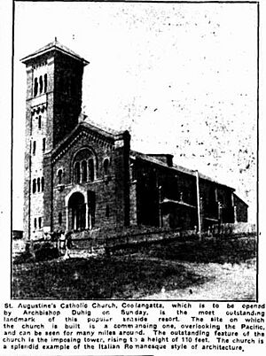
St Augustine's Catholic Church opened in 1926. It has a tall tower and overlooks the ocean. St Augustine's Catholic School also started in 1926. It moved to Currumbin Waters in 1987.
St Peter's Anglican Church was built in 1938. It closed around 2013.
Later 1900s
In 1954, a cyclone hit Coolangatta. It caused a lot of damage. The railway line closed in 1961. More people started using cars instead.
Many early buildings in Coolangatta are now gone. But some older places still stand. These include the Coolangatta Hotel and St Augustine's Catholic Church (Coolangatta). Other historic sites are the former Coolangatta State School and the Anzac Memorial (Coolangatta).
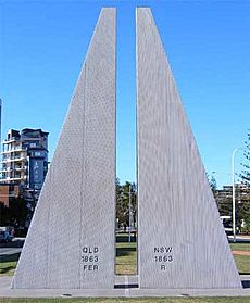
The border fence and gates that used to be here are now removed. But you can still feel the border at Boundary Street. This street runs along the headland.
Coolangatta was home to early tourist spots. These included Jack Evans Porpoise Pool and Gilltraps Auto Museum.
Coolangatta Special School opened in 1979. It was on the old Coolangatta State School site. In 2006, it moved and was renamed. The old school buildings became the Kirra Hill Cultural and Community Centre.
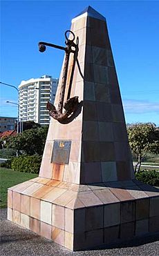
In 1984, a stone from the original Coolangatta Estate in New South Wales was given to the town. It was placed on a special monument.
Coolangatta Today
The Coolangatta library opened in 2013.
In 2020 and 2021, the Queensland border closed again. This was due to the COVID-19 pandemic. Coolangatta had police checkpoints at its border crossings.
Coolangatta's Geography
Coolangatta and its nearby "Twin Town" of Tweed Heads share an economy. The Tweed River has a busy fishing fleet. Fresh seafood is a local favorite.
There are three hills in Coolangatta:
- Kirra Hill is 27 meters high. Its name might mean white cockatoo or fire.
- Greenmount Hill is 32 meters high. It was named after a guest house.
- Murraba is 70 meters high. It is on the border with New South Wales.
Point Danger is a headland on the border. Many people think James Cook named it in 1770. He did create the name, but for a different spot. The name was later moved to its current location.
Rainbow Bay is a bay offshore. It was first called Shark Bay. In 1926, it was renamed after a ship called HMS Rainbow.
Coolangatta has three neighborhoods:
- Kirra is named after Kirra Hill.
- Greenmount is named after the guest house.
- Rainbow Bay is named after the bay.
The Point Danger Lighthouse is on the Point Danger headland.
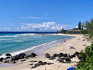
Coolangatta has three main beaches, from west to east:
- Kirra Beach
- Coolangatta Beach
- Greenmount Beach
A breakwater protects Coolangatta Beach from erosion.
The Gold Coast Airport used to be called Coolangatta Airport. It is actually in the neighboring suburb of Bilinga. Part of its runway crosses into New South Wales.
Coolangatta's Weather
Coolangatta has a humid subtropical climate. This means it has warm, wet summers. Winters are cool and moist. March usually gets the most rain. September is the driest month.
| Climate data for Coolangatta | |||||||||||||
|---|---|---|---|---|---|---|---|---|---|---|---|---|---|
| Month | Jan | Feb | Mar | Apr | May | Jun | Jul | Aug | Sep | Oct | Nov | Dec | Year |
| Record high °C (°F) | 35.9 (96.6) |
40.0 (104.0) |
34.6 (94.3) |
32.9 (91.2) |
28.8 (83.8) |
27.5 (81.5) |
29.6 (85.3) |
31.7 (89.1) |
32.8 (91.0) |
35.6 (96.1) |
37.9 (100.2) |
38.0 (100.4) |
40.0 (104.0) |
| Mean daily maximum °C (°F) | 28.6 (83.5) |
28.4 (83.1) |
27.4 (81.3) |
25.5 (77.9) |
23.3 (73.9) |
21.1 (70.0) |
20.8 (69.4) |
21.7 (71.1) |
23.5 (74.3) |
24.7 (76.5) |
26.2 (79.2) |
27.5 (81.5) |
24.9 (76.8) |
| Mean daily minimum °C (°F) | 21.1 (70.0) |
21.0 (69.8) |
19.8 (67.6) |
17.1 (62.8) |
13.8 (56.8) |
11.5 (52.7) |
10.0 (50.0) |
10.5 (50.9) |
13.4 (56.1) |
15.9 (60.6) |
18.2 (64.8) |
19.8 (67.6) |
16.0 (60.8) |
| Record low °C (°F) | 13.5 (56.3) |
15.0 (59.0) |
12.7 (54.9) |
7.3 (45.1) |
1.2 (34.2) |
0.6 (33.1) |
−0.1 (31.8) |
0.5 (32.9) |
3.0 (37.4) |
5.8 (42.4) |
9.3 (48.7) |
12.2 (54.0) |
−0.1 (31.8) |
| Average precipitation mm (inches) | 159.9 (6.30) |
196.4 (7.73) |
202.7 (7.98) |
157.8 (6.21) |
129.3 (5.09) |
131.6 (5.18) |
73.5 (2.89) |
54.8 (2.16) |
42.6 (1.68) |
92.0 (3.62) |
115.5 (4.55) |
157.5 (6.20) |
1,510.7 (59.48) |
| Average precipitation days | 14.7 | 16.4 | 18.4 | 15.7 | 14.9 | 13.0 | 10.2 | 8.0 | 8.5 | 10.5 | 12.1 | 13.8 | 156.2 |
| Average afternoon relative humidity (%) | 69 | 69 | 67 | 64 | 62 | 60 | 56 | 56 | 61 | 66 | 68 | 68 | 64 |
| Source: Bureau of Meteorology | |||||||||||||
People of Coolangatta
In 2016, Coolangatta had 5,948 people. About 2.2% were Aboriginal and Torres Strait Islander people. The average age was 50 years old. Most people (67.6%) were born in Australia. Others came from New Zealand (4.3%) and England (4.0%).
Most people (80.2%) spoke only English at home. Some also spoke Portuguese (1.7%). The most common religions were No Religion (32.3%), Catholic (21.9%), and Anglican (15.4%). By 2021, the population grew to 6,491 people.
Learning in Coolangatta
Coolangatta State School is a government primary school. It teaches students from Prep to Year 6. In 2018, it had 184 students. The school is on Stapylton Street.
There is no secondary school in Coolangatta itself. The closest high school is Palm Beach Currumbin State High School. It is in Palm Beach.
Coolangatta also has a TAFE Queensland campus. TAFE is a technical college. It helps students learn job skills.
Important Places
Coolangatta has important public services. The Coolangatta Magistrates Court is on Musgrave Street. The Coolangatta Police Station is nearby.
Things to Do and See
The Gold Coast City Council runs a public library. It is on Level 1 of the Strand Shopping Centre. The Coolangatta Post Office is also available.
There are four surf life saving clubs in Coolangatta:
- Kirra Surf Life Saving Club
- Coolangatta Surf Life Saving Club
- Tweed Heads Coolangatta Surf Life Saving Club (also called Greenmount Surf Club)
- Rainbow Bay Surf Life Saving Club
The Coolangatta branch of the Queensland Country Women's Association meets at their hall. St Augustine's Catholic Church and Twin Towns Coolangatta Uniting Church are also here.
Sports in Coolangatta
Coolangatta has many sports teams.
The Coolangatta Tweed Heads Australian Football Club plays Australian rules football. The Coolangatta Tweed Barbarians play rugby union. The Coolangatta Surf Life Saving Club competes in swimming championships.
You can also find the Coolangatta Bowls Club. The Coolangatta Croquet Club is on Lanham Street. The Coolangatta & Tweed Heads Golf Club is in nearby Tweed Heads South.
Fun Events
Coolangatta hosts many exciting sports events:
- The Coolangatta Gold (surf life saving race)
- Quiksilver Pro Gold Coast (surfing competition)
- Roxy Pro Gold Coast (surfing competition)
- Beach Cricket Tri-Nations series (beach cricket)
Every June, Coolangatta holds the Cooly Rocks On Festival. This two-week festival celebrates the 1950s and 1960s. It has free entertainment, hot rods, old cars, and live music.
Billy cart races have also been held on Boundary Street. These races are often part of the Cooly Rocks On Festival.
Coolangatta's Attractions
The beautiful beaches are a main attraction in Coolangatta. Great places for views include:
- Kirra Hill
- Greenmount Hill
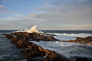
- Snapper Rocks, named after a ship called HMS Snapper
- Point Danger Lighthouse
- Kirra Beach Pavilion
- Razorback Lookout in Tweed Heads
Heritage Sites
Coolangatta has several important heritage sites:
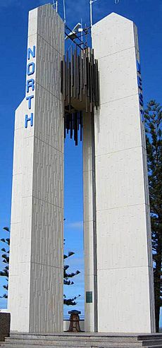
- Boundary Street (New South Wales border): Captain Cook Memorial and Lighthouse
- Boundary Street (median strip): Francis Edward Roberts Commemorative Plaque
- Garrick Street (median strip to north of Musgrave Street): Powell Brothers Commemorative Trees
- 1 Garrick Street: former Coolangatta State & Special School
- Lanham Street (Godwin Park): Coolangatta War Memorial
- Marine Parade (Kirra Beach): Kirra Beach Pavilion
- Marine Parade (Kirra Beach road reserve): Kirra Shelter Shed
- Marine Parade (Queen Elizabeth Park): ANZAC Memorial
- Marine Parade (Queen Elizabeth Park): Wreck of the Coolangatta Fragment
- Marine Parade (Queen Elizabeth Park and Pat Fagan Park): Norfolk Pines Coolangatta Foreshore
- Marine Parade (Pat Fagan Park, Greenmount Hill): United States Navy Coolangatta Leave Area Greenmount Hill Camp No. 4 Picnic Shelter
- Marine Parade (28°10′00″S 153°32′40″E / 28.1667°S 153.5445°E): Tweed Heads and Coolangatta Surf Life Saving Club (formerly Greenmount Surf Life Saving Club)
- 31–33 Mclean Street (28°10′05″S 153°32′07″E / 28.1680°S 153.5352°E): former Jazzland Dance Hall
- 58 McLean Street: St Augustine's Church
- Mouth of Coolangatta Creek, North Kirra Beach: Site of the Wreck of the Coolangatta
- Snapper Rocks (28°09′45″S 153°33′00″E / 28.1626°S 153.5501°E): Remains of Jack Evans Porpoise Pool
See also
 In Spanish: Coolangatta para niños
 | Sharif Bey |
 | Hale Woodruff |
 | Richmond Barthé |
 | Purvis Young |


