Elanora, Queensland facts for kids
Quick facts for kids ElanoraGold Coast, Queensland |
|||||||||||||||
|---|---|---|---|---|---|---|---|---|---|---|---|---|---|---|---|

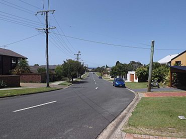
Seaview Parade, 2015
|
|||||||||||||||
| Population | 12,539 (2021 census) | ||||||||||||||
| • Density | 1,409/km2 (3,650/sq mi) | ||||||||||||||
| Established | 1922 | ||||||||||||||
| Postcode(s) | 4221 | ||||||||||||||
| Elevation | 18 m (59 ft) | ||||||||||||||
| Area | 8.9 km2 (3.4 sq mi) | ||||||||||||||
| Time zone | AEST (UTC+10:00) | ||||||||||||||
| Location |
|
||||||||||||||
| LGA(s) | City of Gold Coast | ||||||||||||||
| State electorate(s) | Currumbin | ||||||||||||||
| Federal Division(s) | McPherson | ||||||||||||||
|
|||||||||||||||
Elanora is a suburb located on the Gold Coast in Queensland, Australia. It's a part of the City of Gold Coast area. In 2021, about 12,539 people called Elanora home.
Contents
Where is Elanora?
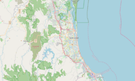
Elanora is nestled between two creeks: Tallebudgera Creek and Currumbin Creek. It's about 13 kilometers west of Coolangatta, a town near the coast. The state capital, Brisbane, is about 94 kilometers to the north.
The suburb has clear boundaries. Tallebudgera Creek is to the northwest. The Pacific Motorway runs along its northeast and east sides. Guineas Creek and Simpsons Roads mark its southeast edge.
Inside Elanora, you'll find schools like Elanora State High School and Elanora Primary School. There's also a smaller local shopping center on Nineteenth Avenue. A bigger shopping center called The Pines is on Guineas Creek Road. Elanora also has a large public library. There are plans for a train station near The Pines Shopping Centre in the future.
Elanora's Story: A Look Back
The name Elanora comes from an Aboriginal word. It means "home by the sea." This name was first given to a railway station in 1922. This station was part of the old South Coast Rail Line.
Here are some important dates in Elanora's history:
- 1927: The Elanora Post Office first opened its doors.
- 1983: Elanora State School welcomed its first students.
- 1983: The Elanora Uniting Church was formed. This happened when three local churches joined together.
- 1990: Elanora State High School opened for older students.
- 2007: The Elanora Branch Library opened. It's located right next to The Pines Shopping Centre.
Who Lives in Elanora?
The population of Elanora has grown over the years.
- In 2006, about 11,681 people lived here.
- By 2011, the population was 11,645. At that time, slightly more than half were female (51.9%). The average age was 41 years old.
- Most people (76.6%) in Elanora were born in Australia. Other common birthplaces included England (6.3%) and New Zealand (5%).
- English was the main language spoken at home by 91.7% of residents.
- In 2016, the population grew to 12,145.
- By 2021, Elanora had 12,539 residents.
Learning in Elanora
Elanora has two main schools for students of different ages.
Elanora State School
This is a government primary school. It teaches students from Preparatory (Prep) to Year 6. It's located on K P McGrath Drive. In 2017, the school had over 1,000 students. It also offers a special education program.
Elanora State High School
This is a government secondary school. It teaches students from Year 7 to Year 12. You can find it at the corner of 19th Avenue and Avocado Street. In 2017, about 933 students attended the high school. It also has a special education program.
Places to Visit
Elanora offers a few important community places.
Elanora Branch Library
The Gold Coast City Council runs the Elanora Branch Library. It's a great place to find books and resources. You can find it inside The Pines Shopping Centre on Guineas Creek Road.
Elanora Uniting Church
This church is located at 17 Applecross Way. It serves as a place of worship for the local community.
 | DeHart Hubbard |
 | Wilma Rudolph |
 | Jesse Owens |
 | Jackie Joyner-Kersee |
 | Major Taylor |


