
Springbrook Road facts for kids
Quick facts for kids Springbrook Road |
|
|---|---|

Springbrook Road in 2016
|
|
| Location | Springbrook-Mudgeeraba Road, Springbrook, Gold Coast City, Queensland, Australia |
| Design period | 1919–1930s (interwar period) |
| Built | 1925–1928 |
| Official name: Springbrook Road and Associated Infrastructure, Memorial Cairn, Springbrook Mudgeeraba Road, Toll Road | |
| Type | state heritage (built) |
| Designated | 22 October 1999 |
| Reference no. | 602140 |
| Significant period | 1920s (fabric) |
| Significant components | cutting – road, plaque, lookout/observation platform, trough – drinking, bridge/viaduct – road, memorial – cairn, fountain |
| Lua error in Module:Location_map at line 420: attempt to index field 'wikibase' (a nil value). | |
Springbrook Road is a special road in Springbrook, Gold Coast, Australia. It was built a long time ago, between 1925 and 1928. This road is also known as Memorial Cairn, Springbrook-Mudgeeraba Road, and Toll Road. It's so important that it's listed on the Queensland Heritage Register, which means it's protected for its history and unique features.
Contents
Building the Springbrook Road
Why the Road Was Needed
The Springbrook-Mudgeeraba Road was built to help people settle and develop the Springbrook area in the 1920s. Before this road, it was very hard to get to the Springbrook plateau. The only way in was a walking trail on the western side. Early settlers knew they needed a proper road for their farms to do well.
They worked hard to find a better way off the mountain. Two rough tracks were made through the forest. One went towards the village of Mudgeeraba. This track was later improved in 1914 so that horse-drawn wagons, called "buckboards," could use it.
Designing a Steep Road
In the 1920s, people asked the government to build a new road. Surveyors were worried about how steep the road would be. At that time, a road with a slope of 1 in 18 was considered the steepest possible in Queensland. But the Springbrook road needed a much steeper slope, 1 in 12, and even 1 in 10 in some parts! This was very challenging.
A Swiss engineer named Juries, who had experience with mountain roads, helped with the first survey. The land was so rough that workers had to dig footholds just to carry their delicate survey tools safely. This road is believed to be the first in Queensland built successfully on such a steep slope.
How the Road Was Built
Different parts of the road were built by different contractors. C.J. Hicks started work in March 1925. The section between Neranwood and Wunburra was the hardest. It took until November 1928 to finish about 4 miles of this tough road.
The men who built the road lived in camps nearby. They had tents of different sizes depending on if they were single or had families with them.
Life on the Springbrook Road
The Toll Road Era
The Springbrook Road officially opened in February 1928. It was called the "Toll Road" because drivers had to pay a fee to travel up or down the mountain. A sign at the toll gates told drivers when they could go up or down, as it was a narrow one-way road. The speed limit was 12 miles per hour.
In the 1930s, the toll was nine pence each way, and it went up to one shilling in the 1940s. Mrs. Leu was the gatekeeper. She worked 24 hours a day, no matter the weather, and earned 30 shillings a week. She was very serious about her job, especially when timber wagons used the road often. She would not let any vehicle pass if the time for down-traffic had just ended, just in case a vehicle was still on the road. The toll was finally removed on 30 November 1945.
Special Features of the Road

The road has some interesting features:
- Stone Water Trough: This trough was built by the road workers as a watering spot for their horses. Today, it's a popular spot for tourists to drink fresh spring water.
- Curved Timber Bridges: Two unique curved wooden bridges were built by Charlie Kolb. They were designed to curve around the side of the mountain, which was a very early and clever way to build bridges on steep roads in Queensland. The wooden parts have been replaced, and signs warn that large vehicles cannot use them.

- One-Way Section: There's a part of the road that is still one-way. Near this section, you'll find a water fountain and another water trough, both fed by a nearby spring. They are made of local stone and blend into the landscape.
- Wunburra Lookout: This is a small viewing platform where you can stop and look out over the valley. It offers beautiful views.
- Hardy's Lookout and Memorial Cairn: At Hardy's Lookout, there's a small stone memorial called a cairn. It was built in 1961 by the people of Springbrook to remember the early settlers from 1906. It has a brass plaque with 19 names of these pioneers.
Why Springbrook Road is Important
Springbrook Road and its features are listed on the Queensland Heritage Register because they are important for several reasons:
- History: The road helped the Springbrook area grow and made it easier to get to Springbrook National Park. Before the road, development was very slow.
- Unique Features: The old water trough and fountain are rare examples of how roads were used when horses were common.
- Beauty: The road is very scenic, with natural rock formations and plants next to the old road cuttings. The lookouts, like Wunburra and Hardy's, have always been popular for their amazing views.
- Smart Engineering: This road was one of the first in Queensland to be built successfully on such a steep slope (1 in 12 and 1 in 10). The curved timber bridges also show advanced building techniques for their time.
- Community Connection: The Pioneer Memorial Cairn at Hardy's Lookout is a special reminder of the first settlers in Springbrook.
Images for kids
-
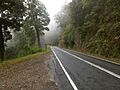
Springbrook Road in 2016
-
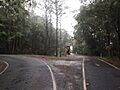
Divided section of Springbrook Road in 2016
-
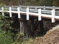
PTE Frederick Anderson Bridge in 2016
