Kerry, Queensland facts for kids
Quick facts for kids KerryQueensland |
|||||||||||||||
|---|---|---|---|---|---|---|---|---|---|---|---|---|---|---|---|

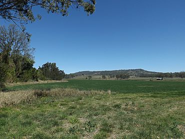
Fields along Albert River, 2014
|
|||||||||||||||
| Population | 306 (2021 census) | ||||||||||||||
| • Density | 3.009/km2 (7.79/sq mi) | ||||||||||||||
| Postcode(s) | 4285 | ||||||||||||||
| Area | 101.7 km2 (39.3 sq mi) | ||||||||||||||
| Time zone | AEST (UTC+10:00) | ||||||||||||||
| Location |
|
||||||||||||||
| LGA(s) | Scenic Rim Region | ||||||||||||||
| State electorate(s) | Scenic Rim | ||||||||||||||
| Federal Division(s) | Wright | ||||||||||||||
|
|||||||||||||||
Kerry is a small country area in the Scenic Rim Region of Queensland, Australia. It's a quiet place where people live in a rural setting. In 2021, about 306 people called Kerry home.
Contents
A Look Back: Kerry's History
Kerry has an interesting past, especially with its large farms and early settlers.
Early Land and Farms
In the early 1840s, a huge piece of land called the Nindooinbah pastoral run was first claimed by Alfred Compigne. Later, William Duckett White bought it. His family owned or rented a massive area. This land stretched from what is now Beaudesert all the way to the Pacific Ocean, near places like Nerang and Southport. Over time, this big property was divided into smaller farms. In 1877, about 12,000 acres of land from the Nindooinbah and Kerrylarabah farms were made available for people to buy. Eventually, Nindooimbah became smaller, and a large part of it was sold to William Collins.
In 1906, many dairy farms were sold in an area known as the Kerry Paddocks. These farms were located along the Albert River and Kerry Creek.
Churches and Schools in Kerry
A site for a Catholic church was set aside in Kerry. St Columba's Catholic Church was built in 1883. It was a small wooden building that also served as a school starting in 1884.
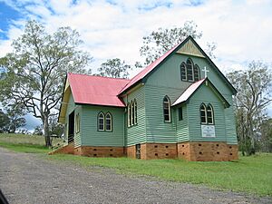
Later, when a new, bigger church was built in nearby Beaudesert, the old St Mary's church from Beaudesert was moved to Kerry. It was then renamed St John's Catholic Church. St John's officially opened on 28 June 1908. You can still find a Catholic cemetery behind the church today. The original St Columba's church building was sold to a local farmer, Tom Plunkett, who used it as a barn.
The Kerry Provisional School first opened on 25 February 1884, using the St Columba's Catholic Church building. It became Kerry State School in 1914 but closed its doors on 28 August 1943. The old school was located at 307 Kerry West Road.
Post Office Services
Kerry had its own Post Office, which opened on 1 July 1927. However, it closed just 12 years later in 1939.
Who Lives in Kerry?
The number of people living in Kerry has changed over the years.
- In 2011, there were 433 people living in Kerry. Most people (87.9%) were born in Australia.
- By 2016, the population was 326 people.
- In 2021, the population was 306 people.
Important Historic Places
Kerry has one special place listed for its history:
- St John’s Catholic Church and Cemetery: Located at 1823 Kerry Road, this church and its cemetery are important parts of Kerry's heritage.
Learning Opportunities: Schools Near Kerry
There are no schools directly in Kerry today. Children living in Kerry usually go to primary schools in nearby towns. The closest government primary schools are Beaudesert State School in Beaudesert (to the north) and Darlington State School in Darlington (to the south). For high school, students typically attend Beaudesert State High School in Beaudesert.
Famous People from Kerry
Some notable people have connections to Kerry:
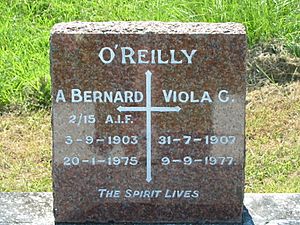
- Bernard O'Reilly: He was a famous bushman and author. He is buried in the St John's Catholic Church cemetery in Kerry.
- Thomas Plunkett, senior: A dairy farmer and politician.
- Thomas Plunkett, junior: Also a dairy farmer and politician, following in his father's footsteps.
 | Valerie Thomas |
 | Frederick McKinley Jones |
 | George Edward Alcorn Jr. |
 | Thomas Mensah |


