Tabooba, Queensland facts for kids
Quick facts for kids TaboobaQueensland |
|||||||||||||||
|---|---|---|---|---|---|---|---|---|---|---|---|---|---|---|---|

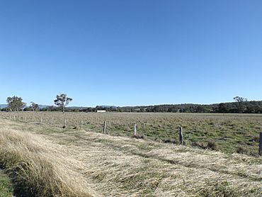
Paddocks along Christmas Creek Road, 2014
|
|||||||||||||||
| Population | 57 (2021 census) | ||||||||||||||
| • Density | 2.365/km2 (6.13/sq mi) | ||||||||||||||
| Postcode(s) | 4285 | ||||||||||||||
| Area | 24.1 km2 (9.3 sq mi) | ||||||||||||||
| Time zone | AEST (UTC+10:00) | ||||||||||||||
| Location |
|
||||||||||||||
| LGA(s) | Scenic Rim Region | ||||||||||||||
| State electorate(s) | Scenic Rim | ||||||||||||||
| Federal Division(s) | Wright | ||||||||||||||
|
|||||||||||||||
Welcome to Tabooba! It's a small, quiet place in the countryside of Queensland, Australia. It's part of the Scenic Rim Region. In 2021, only about 57 people lived here, making it a very peaceful community.
Where is Tabooba?
Tabooba is special because it's where two waterways meet: Christmas Creek and the Logan River. The Logan River forms the western edge of Tabooba. If you go to the eastern part of Tabooba, you'll find hills that are over 400 meters (about 1,300 feet) high, part of the Jinbroken Range.
A Look Back in Time
A long time ago, in 1902, a special train line called the Beaudesert Shire Tramway ran right through Tabooba. There was even a train station here called Tabooba Junction. It was an important spot because the train tracks split here, with one path going to Rathdowney and another to Lamington.
Tabooba also had its own school! Tabooba State School opened on July 24, 1911, but it closed down on August 24, 1942.
Who Lives in Tabooba?
The number of people living in Tabooba has changed over the years. In 2016, there were 72 residents, but by 2021, the population was 57.
 | Janet Taylor Pickett |
 | Synthia Saint James |
 | Howardena Pindell |
 | Faith Ringgold |


