Nindooinbah, Queensland facts for kids
Quick facts for kids NindooinbahQueensland |
|||||||||||||||
|---|---|---|---|---|---|---|---|---|---|---|---|---|---|---|---|

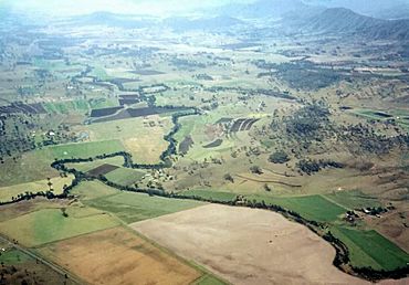
Cainbable Creek meets the Albert River
|
|||||||||||||||
| Population | 95 (2021 census) | ||||||||||||||
| • Density | 1.734/km2 (4.49/sq mi) | ||||||||||||||
| Postcode(s) | 4285 | ||||||||||||||
| Area | 54.8 km2 (21.2 sq mi) | ||||||||||||||
| Time zone | AEST (UTC+10:00) | ||||||||||||||
| Location | |||||||||||||||
| LGA(s) | Scenic Rim Region | ||||||||||||||
| State electorate(s) | Scenic Rim | ||||||||||||||
| Federal Division(s) | Wright | ||||||||||||||
|
|||||||||||||||
Nindooinbah is a small rural area in Queensland, Australia. It is located in the Scenic Rim Region. In 2021, about 95 people lived there.
Contents
Exploring Nindooinbah's Geography
Nindooinbah is located in the beautiful valley of the Albert River. A smaller stream, Cainbable Creek, also flows into the Albert River here. The Albert River forms parts of the eastern and western borders of the area.
Mountains and Farming
To the east, you'll find the Canungra Range. Mount Witheren is part of this range and rises over 560 meters (about 1,800 feet) high. It is also known by its Yugumbir name, Bingingerra. In local Aboriginal stories, this mountain is believed to be the body of a turtle named Bingingerra, who died there after a big fight with sea creatures. In the lower, central parts of Nindooinbah, farming is the main activity.
A Look at Nindooinbah's History
The name Nindooinbah comes from an Aboriginal name. It means "the place of the remains of a fire." This name was first used for a large farm, or "pastoral run," in the early 1840s.
Early Land Ownership
The Nindooimbah farm was first chosen by Alfred Compigne. Later, it was bought by the White family. The White family owned a very large amount of land. This land stretched from the town of Beaudesert all the way to the Pacific Ocean. Over time, this huge land holding was divided into many smaller properties.
The Nindooimbah Estate
In 1906, a part of the Nindooimbah Estate was sold off. This section was called the Kerry Paddocks. It was divided into 26 dairy farms. These farms were located along the Albert River and Kerry Creek.
Nindooinbah State School
Nindooinbah State School opened its doors on May 12, 1913. It helped educate children in the area for many years. The school closed on January 24, 1965. The old school building was located at 540 Nindooinbah Estate Road.
Population of Nindooinbah
In 2016, Nindooinbah had a population of 80 people. By 2021, the population had grown slightly to 95 people.
Places of Interest
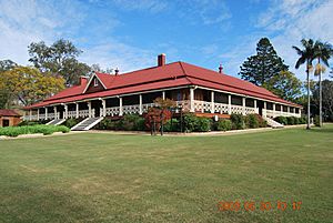
Nindooinbah has some important historical sites. One of these is the Nindooinbah Homestead. It is located on Nindooinbah Connection Road and is a heritage-listed site.
Education in the Area
There are no schools directly in Nindooinbah. Students usually go to schools in nearby towns.
Primary Schools
The closest primary schools are:
- Beaudesert State School in Beaudesert (to the north-west)
- Canungra State School in Canungra (to the north-east)
- Darlington State School in Darlington (to the south)
Secondary Schools
For high school, students can attend:
- Beaudesert State High School in Beaudesert (to the north-west)
- Tamborine Mountain State High School in Tamborine Mountain (to the north-east)
 | May Edward Chinn |
 | Rebecca Cole |
 | Alexa Canady |
 | Dorothy Lavinia Brown |


