Mount Coot-tha Lookout facts for kids
Quick facts for kids Mount Coot-tha Lookout |
|
|---|---|

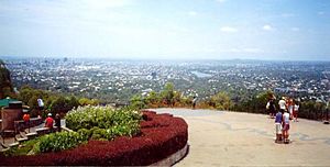
Mount Coot-tha Lookout, 2005
|
|
| Location | Sir Samuel Griffith Drive, Mount Coot-tha, City of Brisbane, Queensland, Australia |
| Design period | 1914 - 1919 (World War I) |
| Built | 1918 - c. 1950 |
| Official name: Mt Coot-tha Lookout & Kiosk, One-Tree-Hill | |
| Type | state heritage (built) |
| Designated | 13 January 1995 |
| Reference no. | 601564 |
| Significant period | 1918, 1928, 1949-1950 (fabric) 1870s-ongoing (social) |
| Significant components | lookout /observation deck, wall/s - retaining, kiosk, tank stand |
| Lua error in Module:Location_map at line 420: attempt to index field 'wikibase' (a nil value). | |
The Mount Coot-tha Lookout & Kiosk is a special place in Mount Coot-tha, Queensland, Australia. It offers amazing views of the city of Brisbane. This site was built between 1918 and around 1950. It is also known as One-Tree-Hill. The lookout and kiosk are so important that they were added to the Queensland Heritage Register on January 13, 1995.
Contents
A Look Back: Mount Coot-tha's History
Mount Coot-tha is part of the Taylor Range. These hills form a beautiful background to the city of Brisbane. It is the most famous spot to see the city and its surroundings. Long ago, Mount Coot-tha was called One-Tree-Hill. This was because the top of the hill had only one large tree.
Early Explorers and Names
The Taylor Range was first named Glenmorrison Range in 1823 by explorer John Oxley. Later, in 1828, it was called Glenmoriston's Range or Sir Herbert Taylor's Range. The first Europeans to climb the hill were botanist Charles Fraser, Captain Patrick Logan, and explorer Allan Cunningham. They climbed it on July 6, 1828. Fraser wrote that the view was "extensive and very grand."
In 1865, someone wanted to buy One-Tree-Hill. But the government said no. They said it was needed for surveying and that people often visited it for fun. They enjoyed the great views and fresh air.
From Timber to Tourist Spot
The Taylor Range had good timber. So, in 1873, One-Tree-Hill became a special area for railway purposes. This was to make sure there was enough timber for the railway from Ipswich to Brisbane.
In 1880, One-Tree-Hill and about 1500 acres around it became a public park. This is when its name changed to Mount Coot-tha. The name "Coot-tha" or "Kuta" comes from the local Aboriginal language. It means "honey" or "place of honey."
Getting to the Top
At first, people used walking tracks to reach the summit. By the 1870s, some visitors even drove up with horses and carriages. When Mount Coot-tha became a park, the track was improved. It became a steep but well-made road. The famous "one tree" was protected by a fence. In 1886, a shelter and water tank were built. Mount Coot-tha also became a bird sanctuary in 1890.
The idea of a "weekend" started around 1900. This made places like Mount Coot-tha more popular. When cars became common, driving to the lookout became a fun activity. By 1918, the old rough tracks were replaced with good roads. This made it easy for everyone to reach the top. This road is now called Sir Samuel Griffith Drive.
In 1918, the park's managers asked the Greater Brisbane Council to take over. Around this time, a new kiosk was built next to the old shelter.
The Kiosk's Story
The first shelter at Mount Coot-tha was an open timber building with a water tank. It was finished in 1886. It had tables, benches, and fireplaces for picnickers. The caretaker's wife ran a small kiosk nearby. She served tea to visitors.
Around 1912, a small timber kitchen was added. Then, around 1918, a larger open-sided kiosk was built. This is the main part of the building you see today. In 1928, plans show the kiosk was made twice as big. It also got a two-story section for living quarters. The old shelter and kitchen were removed. The roof was changed, and a chimney was added. These changes made the kiosk ready for more visitors.
In 1949, more changes were planned. These included updates to the kitchen and living areas. In 1950, the kiosk got a circular drive, a new entrance, and new bathrooms. The current roof tiles were added after 1950. The city architect, Frank Gibson Costello, designed these updates. He also designed the lookout next door.
Today, the kiosk has had some small changes inside. An entrance pergola and new signs have also been added.
The Lookout's Story
Enjoying the view has always been the most popular thing to do at Mount Coot-tha. In 1882, two princes, the Duke of Clarence and Prince George (who later became King George V), visited. They planted two Moreton Bay Fig trees at the top. By 1902, the viewing spot was more formal. It had a stone pillar with a metal plate showing directions to distant places. There were also railings and a telescope you could pay to use.
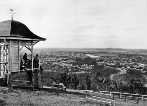
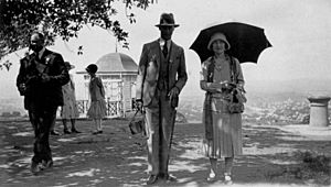
Around 1918, a small viewing gazebo was built. It had an interesting roof shape and a telescope. In 1927, the Duke and Duchess of York visited. They were photographed at the direction finder.
In 1950, City Architect Frank Gibson Costello designed the current lookout. It has a raised viewing platform with a concrete roof. There is also a large platform that spreads out over a stone wall. The trees at the summit were cleared to build this platform. The 1950 plan also showed a drinking fountain. Today, a carpark is located next to the lookout.
What You See Today
The Mount Coot-tha Lookout and Kiosk are at the very top of Mount Coot-tha. They are located along Sir Samuel Griffith Drive.
The Kiosk Building
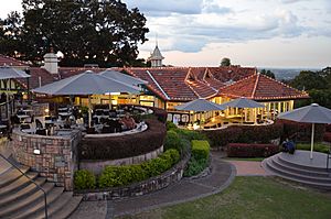
The kiosk is north of the lookout. It is a single-story timber building on a stone base. It has a roof with terra-cotta tiles. The roof has a central vent (called a fleche) and decorative pieces (finials).
The building started as an open-sided kiosk. Now, it has two main sections joined together. There is also a two-story service area at the back. The kiosk has sliding windows that can be hidden in the wall below. The lower part of the wall has panels made of fibrous cement. The service area has timber weatherboard siding.
A tall timber frame that once held a water tank is located north of the building.
The Lookout Area
The lookout is at the highest point of the site, on the southern side. It offers views from the south to the northeast. It features a large viewing platform that extends out. This platform sits above a stone wall made of porphyry stone. Metal railings surround the platform. At the very southern end, there is a raised viewing platform.
This raised platform is shaped like an octagon. It has steps and garden beds with stone walls. The floor of the platform is made of terrazzo with a brass star pattern. A concrete roof is supported by steel posts. A carpark is located to the west of the lookout.
Why It's Special: Heritage Listing
The Mount Coot-tha Lookout & Kiosk was added to the Queensland Heritage Register on January 13, 1995. This means it is a very important historical site.
A Piece of Queensland's Past
This place helps us understand how Queensland's history has changed. Since 1828, it has been known as the best spot for views. Over time, more and more people visited the summit. This shows how leisure time became more common for everyone. It also shows how popular cars became.
A Great Example of Its Kind
The Kiosk is a good example of a building that has changed over time. It has been updated to meet new needs, but it still looks like its original self. The way it has grown is clear to see. The building from around 1918 is still the main part of the structure. The Lookout is a good example of 1950s design.
Beautiful Design
Both the Kiosk and the Lookout show the high quality of buildings designed by the Brisbane City Council. They are great examples of city architecture.
 | Victor J. Glover |
 | Yvonne Cagle |
 | Jeanette Epps |
 | Bernard A. Harris Jr. |


