North Pine Dam facts for kids
Quick facts for kids North Pine Dam |
|
|---|---|

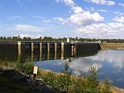
The dam wall in 2006, with the reservoir at 27% of capacity.
|
|
|
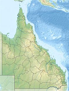
Location of the North Pine Dam
in Queensland |
|
| Country | Australia |
| Location | South East Queensland |
| Coordinates | 27°15′48″S 152°56′12″E / 27.26333°S 152.93667°E |
| Purpose | Potable water supply |
| Status | Operational |
| Opening date | 12 August 1976 |
| Construction cost | A$20 million. |
| Operator(s) | SEQ Water |
| Dam and spillways | |
| Type of dam | Gravity dam |
| Impounds | North Pine River |
| Height | 45 m (148 ft) |
| Length | 1,375 m (4,511 ft) |
| Dam volume | 450×103 m3 (16×106 cu ft) |
| Spillway type | Controlled |
| Spillway capacity | 3,700 m3/s (130,000 cu ft/s) |
| Reservoir | |
| Creates | Lake Samsonvale |
| Total capacity | 214,302 ML (47,140×106 imp gal; 56,613×106 US gal) |
| Catchment area | 348 km2 (134 sq mi) |
| Surface area | 2,200 ha (5,400 acres) |
| Normal elevation | 39.63 m (130.0 ft) AHD |
The North Pine Dam is a large dam in Queensland, Australia. It is built across the North Pine River in the South East region of Queensland. This dam is super important because it provides drinking water for the Moreton Bay area and the northern parts of Brisbane. The big lake formed by the dam is called Lake Samsonvale.
Contents
Where is the North Pine Dam?
The dam is located north-west of Brisbane. You can find it in the Moreton Bay region, specifically in a place called Joyner. It's also close to the towns of Whiteside and Petrie.
The North Pine Dam was built by a company called Transfield. It cost about A$20 million to build. The dam officially opened on 12 August 1976. The Lord Mayor of Brisbane City Council, Alderman Frank Sleeman, was there for the opening.
How the Dam Works
The dam wall is made of concrete and is 45 metres (148 ft) high. It stretches for 1,375 metres (4,511 ft) across the river. This huge wall holds back a massive amount of water, about 215,000 megalitres (47×109 imp gal; 57×109 US gal) when the dam is full.
The water for the dam comes from a large area of 347 square kilometres (134 sq mi). This area includes parts of the D'Aguilar National Park. Lake Samsonvale sits at an elevation of 39.63 m (130.0 ft) above sea level. The lake covers a surface area of 2,180 hectares (5,400 acres).
The dam has a special part called a gated spillway. This spillway has five steel gates. These gates can release a lot of water, up to 3,700 cubic metres per second (130,000 cu ft/s), if the dam gets too full.
Since July 2008, the dam has been managed by SEQ Water. This was part of a big project to make sure South East Queensland has enough water. The plant that cleans the water from the dam is also run by SEQ Water.
Before the dam was built, the valley was filled with farms. Many of these farms were bought by the government to make way for the dam. Today, you can still see road names like Winn Road and Golds Scrub Lane. These names remind us of the farms that used to be there. Golds Scrub Lane now only leads to the Samsonvale Cemetery. Before the dam, there was also a church and a post office at that site. To build the dam, about 27 kilometres (17 mi) of roads had to be moved and rebuilt.
In May 2007, the dam stopped supplying water for a while. This was a safety step because water levels were very low due to a drought in Australia. The dam was only at 14% of its capacity, which was the lowest it had ever been. Stopping the water supply helped protect the dam from harmful blue-green algae that could grow in the warmer months. Even then, the dam still released a small amount of water, about 8–10 megalitres (1.8×10⁶–2.2×10⁶ imp gal; 2.1×10⁶–2.6×10⁶ US gal) per day, to keep the North Pine River flowing.
How the Dam Helps with Floods
The North Pine Dam was mainly built to store water. It wasn't designed much for stopping floods. Because of this, during heavy rain, the dam's spillway can cause Youngs Crossing Road to flood and close.
The dam's area has seen floods in October 2010, and before that in 1991, 1989, 2000, and 2009. The North Pine Dam is also one of the few dams in Queensland located upstream of a big city area. Experts say that if the dam ever failed, the city below could be flooded within three hours.
Fun Things to Do at Lake Samsonvale
There are some rules about what you can do at Lake Samsonvale and the land around it. Many activities are not allowed, like swimming, water skiing, diving, mountain biking, horse riding, canoeing, kayaking, camping, and bushwalking.
However, there are picnic areas at four spots around the dam. You can enjoy a picnic there, but access is only allowed during daylight hours.
Fishing at the Dam
For many years, fishing was not allowed in the dam. But now, Lake Samsonvale has been stocked with different kinds of freshwater fish by the Pine Rivers Fish Stocking Association. You can find fish like spangled perch, snub-nosed garfish, golden perch, silver perch, eastern freshwater cod, saratoga, and Australian bass.
The dam is also home to a fish called tilapia. This fish can be good for sport fishing when it's big. However, it can also multiply too quickly and cause problems for other fish. You can also find Australian red claw crayfish in the dam. These crayfish are usually found in Northern Queensland. People in the area try to catch and remove both tilapia and red claw to help the lake's environment.
If you want to fish in North Pine Dam, you need a special permit called a stocked impoundment permit. This is common for many freshwater fishing spots in Queensland.
Boating Rules
Most boating on Lake Samsonvale is not allowed. However, two groups have special permission for non-petrol powered boats. The Lake Samsonvale Water Sports Association and the Pine Rivers Fish Stocking Association [1] offer 300 permits each year to the public for a small fee.
 | Stephanie Wilson |
 | Charles Bolden |
 | Ronald McNair |
 | Frederick D. Gregory |


