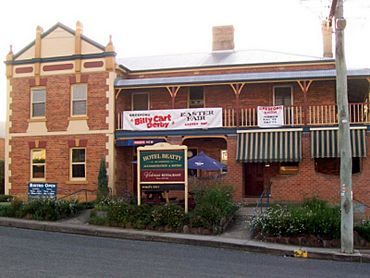
East Gresford, New South Wales facts for kids
Quick facts for kids East GresfordNew South Wales |
|||||||||||||||
|---|---|---|---|---|---|---|---|---|---|---|---|---|---|---|---|

Hotel Beatty, East Gresford
|
|||||||||||||||
| Population | 289 (2006 census) | ||||||||||||||
| Postcode(s) | 2311 | ||||||||||||||
| Elevation | 72 m (236 ft) | ||||||||||||||
| Location | |||||||||||||||
| LGA(s) | Dungog Shire | ||||||||||||||
| State electorate(s) | Upper Hunter | ||||||||||||||
| Federal Division(s) | Lyne | ||||||||||||||
|
|||||||||||||||
|
|||||||||||||||
East Gresford is a small village in the Hunter Region of New South Wales, Australia. It's part of Dungog Shire. This village is about 192 kilometers (119 miles) north of Sydney. The closest bigger towns are Singleton, about 42 kilometers (26 miles) southwest, and Maitland to the south. In 2006, only 289 people lived here.
Contents
Discovering East Gresford's Past
The land around East Gresford has a long history. The Gringai clan of the Wonnarua people are the traditional owners of this area. They are a group of Indigenous Australians. The village itself was likely named after a place called Gresford in Wales.
Getting Around East Gresford
You can travel to and from East Gresford by bus. Hunter Valley Buses runs one main bus route through the village:
- 185: This bus goes from Maitland to Gresford. It passes through places like Bolwarra, Paterson, Vacy, and Torryburn.
Exploring East Gresford and Its Surroundings
Did you know there are actually two small villages named 'Gresford'? There's Gresford (sometimes called West Gresford) closer to Singleton. Then there's East Gresford, which is closer to Maitland.
Gresford is the older, original town. It's where the local school and the Anglican church are located. However, East Gresford is much larger. It has the main shops and is home to the Gresford Scorpions Soccer Club.
Community Life and Local News
The Gresford & District Community Group helps keep everyone in the area connected. They create the Gresford News. This is a colorful monthly newspaper that shares what's happening in the district. About 800 copies are printed each month.
The Community Group also started a special garden called an arboretum. This garden features local native trees and endangered plants. It's becoming a popular spot for groups to visit and learn about these important plants.
Nature and Fun Activities
East Gresford is close to the amazing Barrington Tops National Park. This park has the highest peak in the Hunter Valley. It's also a World Heritage site, known for its ancient rainforests. It even snows in this area during winter!
Park Street in East Gresford is famous for the exciting Gresford Billy Cart Derby. This race usually happens every year on Easter Saturday. Racers start from a ramp next to The Beatty Hotel. They zoom down the hill and finish near the East Gresford Showground. The event took a break during the Covid-19 Pandemic but has since returned.
The annual Gresford Show is another big event. In 2020, it was held in March. The showground is also a great place for camping because it's right next to the Allyn River.
You can find more information and updates about activities in the monthly Gresford News. It's also available online!
East Gresford's Climate
The areas around East Gresford have a humid subtropical climate. This means they have hot summers and cool, drier winters. It's quite similar to the weather in the Greater Western Sydney region.
| Climate data for Lostock Dam | |||||||||||||
|---|---|---|---|---|---|---|---|---|---|---|---|---|---|
| Month | Jan | Feb | Mar | Apr | May | Jun | Jul | Aug | Sep | Oct | Nov | Dec | Year |
| Record high °C (°F) | 43.5 (110.3) |
45.6 (114.1) |
39.8 (103.6) |
36.7 (98.1) |
27.8 (82.0) |
25.0 (77.0) |
26.0 (78.8) |
28.3 (82.9) |
35.5 (95.9) |
38.5 (101.3) |
43.7 (110.7) |
42.0 (107.6) |
45.6 (114.1) |
| Mean daily maximum °C (°F) | 29.6 (85.3) |
28.6 (83.5) |
26.7 (80.1) |
23.6 (74.5) |
20.1 (68.2) |
17.0 (62.6) |
16.6 (61.9) |
18.5 (65.3) |
21.8 (71.2) |
24.7 (76.5) |
26.7 (80.1) |
28.9 (84.0) |
23.6 (74.5) |
| Mean daily minimum °C (°F) | 17.3 (63.1) |
17.2 (63.0) |
15.5 (59.9) |
12.6 (54.7) |
9.9 (49.8) |
7.7 (45.9) |
6.4 (43.5) |
6.8 (44.2) |
9.3 (48.7) |
11.8 (53.2) |
13.9 (57.0) |
16.1 (61.0) |
12.0 (53.6) |
| Record low °C (°F) | 9.2 (48.6) |
10.2 (50.4) |
5.6 (42.1) |
3.6 (38.5) |
0.7 (33.3) |
1.2 (34.2) |
−1.7 (28.9) |
−0.4 (31.3) |
1.0 (33.8) |
3.3 (37.9) |
6.0 (42.8) |
6.8 (44.2) |
−1.7 (28.9) |
| Average precipitation mm (inches) | 124.2 (4.89) |
123.7 (4.87) |
124.4 (4.90) |
74.8 (2.94) |
70.1 (2.76) |
68.4 (2.69) |
38.3 (1.51) |
35.9 (1.41) |
48.1 (1.89) |
66.7 (2.63) |
90.3 (3.56) |
94.7 (3.73) |
973.7 (38.33) |
| Average precipitation days | 12.8 | 12.4 | 13.1 | 11.1 | 11.0 | 12.3 | 10.2 | 8.8 | 9.4 | 11.0 | 13.0 | 11.8 | 136.9 |
| Average relative humidity (%) | 53 | 59 | 61 | 55 | 56 | 61 | 54 | 46 | 43 | 50 | 50 | 45 | 53 |
 | Janet Taylor Pickett |
 | Synthia Saint James |
 | Howardena Pindell |
 | Faith Ringgold |


