Allyn River facts for kids
Quick facts for kids Allyn |
|
|---|---|

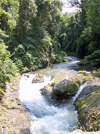
Allyn River, surrounded by sub tropical rainforest
|
|
|
Location of the Allyn River mouth in New South Wales
|
|
| Country | Australia |
| State | New South Wales |
| Region | NSW North Coast (IBRA), Hunter |
| LGA | Dungog |
| Town | East Gresford |
| Physical characteristics | |
| Main source | Allyn Range, Barrington Tops near Careys Peak 655 m (2,149 ft) 32°21′42.9″S 151°31′55.668″E / 32.361917°S 151.53213000°E |
| River mouth | Paterson River Vacy 15 m (49 ft) 32°3′43.26″S 151°24′57″E / 32.0620167°S 151.41583°E |
| Length | 82 km (51 mi) |
| Basin features | |
| River system | Hunter River catchment |
| Tributaries |
|
The Allyn River is a beautiful stream located in the Hunter area of New South Wales, Australia. It's a part of the larger Hunter River system.
About the Allyn River
The Allyn River begins high up in the Allyn Range, on the slopes of the amazing Barrington Tops. This area is known for its ancient Gondwana Rainforests. The river then flows mostly towards the southeast.
Along its journey, the Allyn River is joined by seven smaller streams. It travels about 82 kilometers (51 miles) before it meets the Paterson River near a town called Vacy. From where it starts to where it ends, the river drops about 640 meters (2,100 feet) in height.
Journey Through Rainforests
As the Allyn River flows, it passes through incredible World Heritage listed rainforests. These high-up forests are home to unique trees like the Antarctic beech, which is a very old type of tree.
Further down, the river goes through lower subtropical rainforests. Here, you can find trees like Red Cedar and Small leaf fig. Some of the River oak trees growing by the river are super tall, reaching over 50 meters (164 feet)! People have used the trees in this area for logging since the 1820s. The rocks in the middle part of the river's course are mostly sedimentary, like those found in the Allyn River Member.
A Look at History
The valley where the Allyn River flows has a rich history. It is the traditional home of the Gringai clan, who are a group of Wonnarua people. The Wonnarua are one of the many groups of Indigenous Australians who have lived on this land for thousands of years.
 | Janet Taylor Pickett |
 | Synthia Saint James |
 | Howardena Pindell |
 | Faith Ringgold |


