Tomago facts for kids
Quick facts for kids TomagoNew South Wales |
|||||||||||||||
|---|---|---|---|---|---|---|---|---|---|---|---|---|---|---|---|

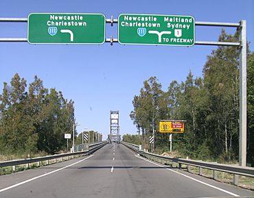
Hexham Bridge connects Tomago to Hexham
|
|||||||||||||||
| Population | 277 (2016 census) | ||||||||||||||
| • Density | 7.1/km2 (18/sq mi) | ||||||||||||||
| Postcode(s) | 2322 | ||||||||||||||
| Elevation | 3 m (10 ft) | ||||||||||||||
| Area | 38.1 km2 (14.7 sq mi) | ||||||||||||||
| Time zone | AEST (UTC+10) | ||||||||||||||
| • Summer (DST) | AEDT (UTC+11) | ||||||||||||||
| Location |
|
||||||||||||||
| LGA(s) | Port Stephens Council | ||||||||||||||
| Region | Hunter | ||||||||||||||
| County | Gloucester | ||||||||||||||
| Parish | Stockton | ||||||||||||||
| State electorate(s) | Port Stephens | ||||||||||||||
| Federal Division(s) | Paterson | ||||||||||||||
|
|||||||||||||||
|
|||||||||||||||
Tomago is a suburb in the Hunter Region of New South Wales, Australia. It's a mix of industrial areas and quiet, semi-rural spots. Tomago is found just north of the Hunter River and west of a water area called Fullerton Cove. The name "Tomago" comes from the local Aboriginal language and means "sweet water." In 2016, about 277 people lived in Tomago. Most residents were born in Australia and spoke only English at home.
Contents
Exploring Tomago's Geography
Tomago is mostly flat land with sandy soil. Water surrounds the suburb on three sides. The Hunter River flows around its western and southern edges. To the east, you'll find Fullerton Cove.
It's important to know that you can't directly reach the nearby suburbs of Tarro, Kooragang, or Fullerton Cove by land from Tomago. The only way to get to and from Hexham is by using the Hexham bridges. These bridges are actually located in the suburb of Tarro.
Key Industries in Tomago
Tomago is home to several important industrial sites. One major site is the Tomago aluminium smelter, which produces aluminium. Another is the Forgacs Shipyard, where ships are built or repaired. The Tomago Sandbeds water treatment works also operates here, helping to treat water.
In the past, other companies had a presence in Tomago. Until 1999, ABB Engineering Construction made coal wagons for the Hunter Valley Coal Chain. These wagons were used to transport coal. Later, in 2009, a company called Volgren opened a factory to build bus bodies. However, this factory closed in 2012.
Discovering Hunter Region Botanic Gardens
The Hunter Region Botanic Gardens are located next to the eastern side of the Pacific Highway. You'll find them in the northern part of Tomago. These gardens cover a large area of about 140 hectares (346 acres).
Within the gardens, 30 hectares (74 acres) are designed as themed parks. The remaining 105 hectares (259 acres) are natural bushland. This means you can explore both beautifully arranged gardens and untouched natural areas.
Historic Tomago House and Chapel
Tomago House and its nearby chapel are important historical buildings. They are listed as heritage sites. You can find them on Tomago Road, which is the main road through the suburb. This road also leads from the Pacific Highway to Newcastle Airport.
The chapel is located about 250 meters (820 feet) west of Tomago House. It sits on a different piece of land. Both buildings offer a glimpse into the history of the area.
 | Charles R. Drew |
 | Benjamin Banneker |
 | Jane C. Wright |
 | Roger Arliner Young |


