
Kooragang facts for kids
Quick facts for kids KooragangNewcastle, New South Wales |
|||||||||||||||
|---|---|---|---|---|---|---|---|---|---|---|---|---|---|---|---|

The former Alexander Walker Scott's Estate on Ash Island
|
|||||||||||||||

Kooragang
Location in Newcastle, Australia
|
|||||||||||||||
| Population | 0 (2016 census) | ||||||||||||||
| • Density | 0/km2 (0/sq mi) | ||||||||||||||
| Postcode(s) | 2304 | ||||||||||||||
| Elevation | 3 m (10 ft) | ||||||||||||||
| Area | 35.4 km2 (13.7 sq mi) | ||||||||||||||
| Time zone | AEST (UTC+10) | ||||||||||||||
| • Summer (DST) | AEDT (UTC+11) | ||||||||||||||
| Location | |||||||||||||||
| LGA(s) | City of Newcastle | ||||||||||||||
| Region | Hunter | ||||||||||||||
| County | Northumberland | ||||||||||||||
| Parish | Newcastle | ||||||||||||||
| State electorate(s) | Newcastle | ||||||||||||||
| Federal Division(s) | Newcastle | ||||||||||||||
|
|||||||||||||||
|
|||||||||||||||
Kooragang is the largest suburb of the city of Newcastle in New South Wales, Australia. It is mostly made up of Kooragang Island. The eastern part of Kooragang is mainly for industries, while the western part has important nature reserves.
Kooragang covers an area of about 35.4 square kilometres (13.7 sq mi). In 2016, no one lived in the suburb.
Contents
Exploring Kooragang's Location
Kooragang stretches about 12.4 kilometres (7.7 mi) from Stockton in the southeast to Hexham in the northwest. The Hunter River forms most of Kooragang's borders. It is about 3.8 kilometres (2.4 mi) wide at its widest point.
You can get to Kooragang by three bridges. The Tourle Street Bridge from Mayfield West is the main way to reach Kooragang and nearby areas like Stockton. The Stockton Bridge connects Kooragang to Stockton in the east. To reach the western part of Kooragang, you can use the Ash Island bridge at Hexham.
Kooragang is mostly flat and low-lying. The industrial area on Kooragang Island in the east has some raised sections.
Kooragang's Past
Kooragang is mostly made up of Kooragang Island. This island was created by joining several smaller islands in the Hunter River. These smaller islands, like Ash Island and Moscheto Island, were separated by mud flats and channels. Europeans first explored and mapped them in 1801.
Ash Island was the biggest of these original islands. It was named for the Ash trees that grew there. By 1821, many trees on the island had been cut down. In 1827, Alexander Scott was given a large piece of land there. He settled on the island in 1831, and a community grew with many visitors.
A wooden bridge once connected Ash Island to the mainland. Later, a concrete bridge replaced it, which is still used today. About 50 families lived on Ash Island until a big flood in 1955 caused a lot of damage.
By the 1960s, a plan began to combine the smaller islands into Kooragang Island. This was done to make space for new industries near Newcastle. The western part of Kooragang Island is now a nature area called the Kooragang Wetland Rehabilitation Project. It is still known as Ash Island.
Kooragang Island Today
Coal Exports: A Busy Port
The eastern part of Kooragang Island is a very important port for exporting coal. It started in 1984 and could handle 15 million tonnes of coal each year. By 2013, its capacity grew to 120 million tonnes per year.
In July 2013, a record 10.3 million tonnes of coal passed through the port of Newcastle. Most of this coal was loaded onto ships at the Kooragang terminal. Coal trains bring coal from Hunter Valley coal mines to Kooragang Island using a special railway system.
Other Industries on Kooragang Island
Besides coal, many other businesses operate on Kooragang Island. Some of these were there even before the coal port was built. These industries include Mountain Industries, which makes bitumen (used in roads), and Blue Circle Southern Cement.
You can also find Sims Metal recyclers and Orica Kooragang here. Orica Kooragang started in 1969. It makes fertiliser for farms and explosives for mining.
Past Electricity Generation

A large wind turbine was put on Kooragang Island in 1997. It was 600 kilowatts and could power about 150 homes each year. This turbine was a well-known sight for many years. However, it was taken down on October 29, 2014. The turbine was later moved and set up in Tasmania.
Ash Island: A Natural Gem
Ash Island is about 12 kilometres (7.5 mi) west of Newcastle's city centre. It covers an area of about 780 hectares (1,900 acres). You can reach it by a road bridge at the western end.
Ash Island is home to over 200 types of birds and 15 types of frogs. It also has more than 300 native plant species. The island features different natural areas like rainforests, mangroves, and saltmarshes.
Ash Island's Rich History
The Worimi and Awabakal Indigenous groups first used this area as a major source of food. In 1797, Europeans found red cedar and ash trees here. Captain William Paterson ordered a survey of the area in 1801.
In the 1800s, industrial activities began on the island. By the 1860s, the land was changed into farms, including 17 dairy farms where 55 families lived. After major floods in 1955, all the families moved out. The NSW government then took control of the land and leased it for grazing.
In the 1960s, a large industrial development started. By 1968, Ash Island became part of Kooragang Island. In 1984, the area was named a Ramsar site, which means it's an important wetland. The Kooragang Nature Reserve was formed in 1983, and the Kooragang Wetlands Rehabilitation Project started in 1993.
Famous Visitors to Ash Island
In 1827, Alexander Walker Scott bought a large piece of land on Ash Island. In 1846, he moved there with his family, including his daughters Helena and Harriet. Both Harriet and Helena became famous artists. Many of their letters are kept at the Australian Museum.
Friedrich Wilhelm Ludwig Leichardt was a German artist who visited the Hunter Region in 1842. Alexander Walker Scott invited him to Ash Island. Leichhardt spent a few days there, and many of his sketches are now in the National Library of Australia.
Conrad Marten was an English artist who sailed on Charles Darwin's ship, HMS Beagle. He visited the Hunter area, including Ash Island, between 1841 and 1852. His drawings from the Hunter area are available online through the State Library of New South Wales.
Heritage Sites
The 131 Radar Station on Ash Island is a special site listed for its heritage.
Images for kids
-
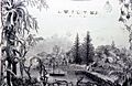
The former Alexander Walker Scott's Estate on Ash Island
-
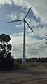
The wind turbine on Kooragang Island was a visible landmark for many years.
