
Tarro, New South Wales facts for kids
Quick facts for kids TarroNewcastle, New South Wales |
|||||||||||||||
|---|---|---|---|---|---|---|---|---|---|---|---|---|---|---|---|
.JPG)
Tarro General store reopened 2010
|
|||||||||||||||

Tarro
Location in the Hunter-Central Coast Region
|
|||||||||||||||
| Population | 1,645 (2016 census) | ||||||||||||||
| • Density | 1,948/km2 (5,050/sq mi) | ||||||||||||||
| Postcode(s) | 2322 | ||||||||||||||
| Elevation | 10 m (33 ft) | ||||||||||||||
| Area | 6 km2 (2.3 sq mi) | ||||||||||||||
| Time zone | AEST (UTC+10) | ||||||||||||||
| • Summer (DST) | AEDT (UTC+11) | ||||||||||||||
| Location |
|
||||||||||||||
| LGA(s) |
|
||||||||||||||
| Region | Hunter | ||||||||||||||
| County | Northumberland | ||||||||||||||
| Parish | Alnwick | ||||||||||||||
| State electorate(s) | Wallsend | ||||||||||||||
| Federal Division(s) | Paterson | ||||||||||||||
|
|||||||||||||||
Tarro (/tæroʊ/) is a suburb located in the north-west of Newcastle, Australia. It's part of the City of Newcastle local council area in the Hunter Region of New South Wales.
Tarro, along with parts of nearby Beresfield, was once known as Upper Hexham. The name "Tarro" is believed to mean "stone" in an Aboriginal language. In 2016, about 1,645 people lived in Tarro.
Contents
Geography of Tarro
Tarro and its neighbouring suburbs like Beresfield, Woodberry, and Thornton are built on small hills. These hills rise out of the flat areas and wetlands near the Hunter River.
How Tarro Grew
In the early days, Tarro had many scattered farms. People used the nearby wetlands for farming. Houses were mostly found along Maitland Road, which was then the main highway. After World War II, Tarro started to become more like a typical suburb. New areas were divided into blocks for houses. This growth continued through the 1960s, 70s, and 80s, with many new homes being built.
Hunter River and Bridges
A part of the Hunter River, about 3.4 km (2.1 mi) long, runs through the eastern and south-eastern areas of Tarro. The suburb reaches the Hexham bridges, where it meets the suburb of Kooragang. Even though they are called the Hexham bridges, they are actually located in Tarro. The southbound bridge forms the border between Tarro and Kooragang.
History of Tarro
First People of the Land
The land where Tarro is now located was originally home to the Pambalong clan. They were part of the Awabakal people. Their territory, known as Barrahineban, stretched along the southern bank of the Hunter River. It went from Newcastle West, through Hexham (Tarro), and towards Mount Sugarloaf.
Early Churches

In 1841, a settler named Edward Sparke Snr gave land for a Church of England building and a burial ground. A church called St Stephens opened in Tarro around 1849. This first church was a simple building. It was later replaced by a nicer wooden church in 1905. There was also a house for the church leader. St Stephens church was sold and removed around 1980. The spot where it stood is now part of the Tarro Interchange on the New England Highway.
Tarro also has an old pioneer cemetery on Quarter Sessions Road. People have been buried there since the mid-1800s. The foundation stone for Our Lady of Lourdes Catholic Church was laid on December 4, 1922.
Post Office History

Tarro's first post office was called Upper Hexham. It was located at the railway station. Around 1918, the post office moved to Woodberry Road. Later, it moved to 13 Maitland Road, which is now Anderson Drive. This post office also had the manual telephone switchboard until 1957. The post office closed on July 30, 1993. Now, people in Tarro use the Beresfield Post Office.
Tarro Railway Station
Tarro has a railway station that opened in 1857. It was part of the first railway line from Newcastle to Maitland. This was the beginning of the Main North line that goes from Sydney to the New England region.
The station was first known as Hexham when it opened. In 1871, its name changed to Hexham Township, and then to Tarro. Today, the station is served by NSW TrainLink's Hunter line. The railway station used to be much larger. It had offices and waiting rooms. These buildings were taken down in the 1970s and replaced with simple shelters.
Tarro's Population
According to the 2016 Census, the average age in Tarro is 45 years old. The suburb has 1,645 residents. About 5.1% of residents are Aboriginal or Torres Strait Islander people. The average age for this group is 19. Tarro has more residents aged 65 and over (24.4%) compared to the national average (15.8%).
Most residents (86.3%) were born in Australia. Other common birthplaces include England (2.5%), New Zealand (0.9%), and Taiwan (0.8%). The most common family backgrounds reported in Tarro are English, Australian, and Irish. About 75.2% of residents have both parents born in Australia.
The main religious groups in Tarro are Anglican (28.6%), Catholic (20.5%), and Uniting Church (6.7%). About 24.7% of residents said they had no religion.
Education in Tarro

The first school in Tarro was held in the home of a church leader in 1844. Around 1860, a school house opened near St Stephens' Church. A government public school opened in Upper Hexham in 1881. This school later became Beresfield Public School. The original schoolhouse is now on the grounds of Beresfield Public School and is considered a historic building.
A second public primary school was built in Tarro itself and opened in 1961. Tarro also has a Catholic primary school, which is next to Our Lady of Lourdes Catholic Church. The closest public high school is Francis Greenway High School in Beresfield. This high school is named after Francis Greenway, an architect who was given land in the Tarro area around 1820.
Other Facilities in Tarro

Tarro has several local shops and services. These include a newsagency and general store, a butcher's shop, a take-away food store, a petrol station, a hotel, and a motel. There is also a fire station and a community hall. You can find a telephone exchange, a water pumping station, and an electricity sub-station here too. The pumping station is a heritage-listed building.
Tarro Park is a sports ground that was created from wetlands. It has soccer and football fields, a playground, and bird ponds.
Police Station
Tarro used to have its own police station, but it closed in 1976. Since then, the area has been served by the Beresfield police station. Now, the main police coverage for Tarro comes from the Maitland Police station.
War Memorial
After World War I, the communities of Tarro and Woodberry created a memorial to honour the soldiers. This memorial was first shown to the public around 1920. It lists 14 soldiers, including five who died in action. The memorial was moved and rededicated in 1974. You can now see it at the Fred Harvey Oval in Woodberry.
Images for kids
-
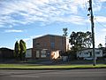
Tarro telephone exchange
-
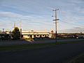
Tarro Hotel
-
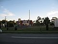
Tarro Fire Station


