
Sandgate, New South Wales facts for kids
Quick facts for kids SandgateNewcastle, New South Wales |
|||||||||||||||
|---|---|---|---|---|---|---|---|---|---|---|---|---|---|---|---|
 |
|||||||||||||||

Sandgate
Location in the Hunter-Central Coast Region
|
|||||||||||||||
| Postcode(s) | 2304 | ||||||||||||||
| Area | 2.3 km2 (0.9 sq mi) | ||||||||||||||
| Location | 11 km (7 mi) NW of Newcastle | ||||||||||||||
| LGA(s) | City of Newcastle | ||||||||||||||
| Parish | Newcastle | ||||||||||||||
| State electorate(s) | Newcastle | ||||||||||||||
| Federal Division(s) | Newcastle | ||||||||||||||
|
|||||||||||||||
Sandgate is a suburb located in Newcastle, New South Wales, Australia. It's about 11 kilometers (around 7 miles) northwest of Newcastle's main city area. This suburb is part of the City of Newcastle local government area.
Long ago, the Awabakal and Worimi people were the very first inhabitants of the Newcastle area, including where Sandgate is today.
Sandgate has its own train station on the Hunter Line. This makes it easy for people to travel to and from the suburb. You can also find Newcastle's largest cemetery here, called Sandgate Cemetery.
History of Sandgate
When Was Sandgate Established?
Sandgate began to grow as a place where people live in the early 1900s. This happened as the city of Newcastle expanded. New housing areas were built, making Sandgate a residential spot for families.
Images for kids
-
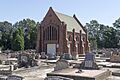
St Joseph Catholic Chapel in Sandgate.
