
Gloucester County, New South Wales facts for kids
Quick facts for kids GloucesterNew South Wales |
|||||||||||||||
|---|---|---|---|---|---|---|---|---|---|---|---|---|---|---|---|

Location in New South Wales
|
|||||||||||||||
|
|||||||||||||||
.png)
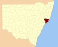
Gloucester County is a special kind of area in New South Wales, Australia. It's like a historical land division, used for mapping and keeping records. It was one of the first 19 such areas created in the region. Today, it's still one of 141 similar divisions in New South Wales.
This county covers the land around Port Stephens. Its northern and western edges are marked by the Manning River. To the south-west, it is bordered by the Williams River.
What is Gloucester County?
Gloucester County was given its name after a place in England called County Gloucester. This was a common practice when Australia was first being settled by Europeans. It helped to organize the land into smaller, manageable sections.
Images for kids
-
Location in New South Wales

All content from Kiddle encyclopedia articles (including the article images and facts) can be freely used under Attribution-ShareAlike license, unless stated otherwise. Cite this article:
Gloucester County, New South Wales Facts for Kids. Kiddle Encyclopedia.