Hawes County facts for kids
Quick facts for kids HawesNew South Wales |
|||||||||||||||
|---|---|---|---|---|---|---|---|---|---|---|---|---|---|---|---|

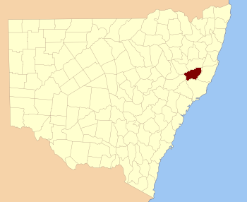
Location in New South Wales
|
|||||||||||||||
|
|||||||||||||||
Hawes County is one of the 141 Cadastral divisions of New South Wales. These are like imaginary areas on a map. They help keep track of land ownership and boundaries. Hawes County is located in New South Wales, Australia. Its southern border is the Manning River.
Hawes County was named to honor Sir Benjamin Hawes (1797–1862). He was a respected person who lived a long time ago.
What is a Cadastral Division?
A cadastral division is a special way to divide land on a map. It helps people know exactly where properties are. These divisions are used for legal reasons, like when land is bought or sold. They are also important for planning and managing land.
Hawes County's Location
Hawes County is in the eastern part of New South Wales. It shares borders with several other counties. These include Parry, Vernon, Dudley, Macquarie, Gloucester, Durham, and Brisbane counties. The Manning River forms a natural boundary to the south.
Parishes in Hawes County
Counties like Hawes are divided into smaller areas called parishes. These parishes are also imaginary land divisions. They help with local administration and record-keeping. Hawes County contains many different parishes. Each parish belongs to a local government area (LGA). These LGAs help manage local services for the people living there.
 | Precious Adams |
 | Lauren Anderson |
 | Janet Collins |

