
Lands administrative divisions of New South Wales facts for kids


New South Wales uses a special system to keep track of its land. It's divided into 141 main areas called counties. Each county is then split into smaller parts called parishes. These counties were first created a long time ago when New South Wales was a British colony, before it became part of Australia.
There are 7,419 parishes in total. The land is also divided in other ways, like into three big land divisions and about a hundred land districts. In the past, there were also 13 special areas called hundreds in Cumberland County, but these were later removed. Unlike the way local councils change their boundaries, these counties have stayed mostly the same since the 1800s.
Contents
How Counties Were Made

The very first county, Cumberland, was created on June 6, 1788. Northumberland was named in 1804. By the 1820s, there were nine counties around Sydney. These included Roxburgh, Northumberland, Durham, Westmoreland, Cumberland, Argyle, Camden, Ayr, and Cambridge. Some of these early counties were much larger than they are today.
In 1825, Governor Brisbane was told to survey New South Wales. He was to divide it into counties, hundreds, and parishes. The famous explorer Thomas Mitchell surveyed the most important ones, known as the Nineteen Counties, in 1834. Even though 13 hundreds were created in Cumberland County, they weren't used anywhere else in New South Wales and were removed in 1888.
Because counties are based on land size, not how many people live there, some counties have huge populations while others have very few. For example, the entire city of Sydney, with millions of people, is inside Cumberland County. But many counties in the Far West have very few residents.
What Counties Are Used For Today
Counties don't have many official jobs anymore. They are mainly used for keeping track of land ownership and for geographic surveys. They also help define areas for some work agreements. Interestingly, Yancowinna County is the only part of New South Wales that uses the South Australian time zone.
If you look at old family records from the 1800s and early 1900s in New South Wales, you'll often see towns listed with their county. For example, the 1911 Britannica encyclopedia listed places like "Albury, Goulburn county" and "Broken Hill, Yancowinna county".
Early Land Districts
Before the county system was fully set up, some areas outside the main counties were divided into "squatting districts" in the early 1800s. Later, in 1846, New South Wales was split into settled, intermediate, and unsettled districts. This system changed again in 1861 with new land laws.
Some of these early districts included:
- Albert District: Located west of the Darling River.
- Bligh District: East of the Macquarie River.
- Clarence River District: Created from the Port Macquarie District.
- Lachlan District: Between the Lachlan River and Murrumbidgee River.
- Liverpool Plains District: A very large area, later split into smaller districts.
- Maneroo District: In the south, now called Monaro.
- Murrumbidgee District: Between the Murrumbidgee and Murray rivers.
- New England District: In the New England region.
Land Divisions and Boards
In 1884, the Crown Lands Act divided New South Wales into three large land divisions: the Western, Central, and Eastern divisions. This act also created Land Boards and Land Districts.
By 1890, there were 14 Land Boards and 95 Land Districts. By 1907, there were 13 Land Boards and 103 Land Districts. These new land districts were different from the earlier ones. The Land Boards were named after the towns where their main offices were located.

Table of Counties
Here is a list of the counties in New South Wales, when they were created, and how many parishes are in each:
| County | Year Created | Number of Parishes |
|---|---|---|
| Argyle | 1821 | 50 |
| Arrawatta | 1862 | 70 |
| Ashburnham | 1850 | 60 |
| Auckland | 1843 | 55 |
| Baradine | 1862 | 78 |
| Barrona | 1884 | 28 |
| Bathurst | 1829 | 67 |
| Benarba | 1862 | 102 |
| Beresford | 1848 | 49 |
| Bland | 1862 | 65 |
| Blaxland | 1862 | 92 |
| Bligh | 1829 | 47 |
| Booroondarra | 1884 | 36 |
| Bourke | 1862 | 55 |
| Boyd | 1862 | 39 |
| Brisbane | 1829 | 58 |
| Buccleuch | 1848 | 35 |
| Buckland | 1848 | 33 |
| Buller | 1850 | 45 |
| Burnett | 1862 | 56 |
| Cadell | 1862 | 28 |
| Caira | 1862 | 80 |
| Camden | 1805 | 55 |
| Canbelego | 1875 | 52 |
| Clarence | 1848 | 40 |
| Clarendon | 1850 | 36 |
| Clarke | 1862 | 51 |
| Clive | 1850 | 54 |
| Clyde | 1862 | 80 |
| Cook | 1829 | 45 |
| Cooper | 1862 | 76 |
| Courallie | 1862 | 54 |
| Cowley | 1848 | 23 |
| Cowper | 1862 | 117 |
| Culgoa | 1884 | 46 |
| Cumberland | 1788 | 57 |
| Cunningham | 1862 | 59 |
| Dampier | 1848 | 41 |
| Darling | 1850 | 36 |
| Delalah | 1884 | 23 |
| Denham | 1862 | 44 |
| Denison | 1862 | 31 |
| Dowling | 1862 | 51 |
| Drake | 1850 | 39 |
| Dudley | 1848 | 37 |
| Durham | 1829 | 63 |
| Evelyn | 1884 | 41 |
| Ewenmar | 1862 | 53 |
| Farnell | 1884 | 34 |
| Finch | 1875 | 120 |
| Fitzgerald | 1884 | 31 |
| Fitzroy | 1862 | 46 |
| Flinders | 1862 | 71 |
| Forbes | 1862 | 38 |
| Franklin | 1862 | 44 |
| Georgiana | 1829 | 59 |
| Gipps | 1862 | 71 |
| Gloucester | 1829 | 79 |
| Gordon | 1850 | 39 |
| Gough | 1862 | 63 |
| Goulburn | 1850 | 38 |
| Gowen | 1850 | 51 |
| Gregory | 1862 | 91 |
| Gresham | 1850 | 33 |
| Gunderbooka | 1875 | 45 |
| Harden | 1850 | 42 |
| Hardinge | 1862 | 45 |
| Hawes | 1848 | 39 |
| Hume | 1862 | 43 |
| Hunter | 1829 | 64 |
| Inglis | 1850 | 22 |
| Irrara | 1884 | 47 |
| Jamison | 1862 | 64 |
| Kennedy | 1862 | 61 |
| Kilfera | 1884 | 15 |
| Killara | 1875 | 53 |
| King | 1829 | 48 |
| Landsborough | 1875 | 25 |
| Leichhardt | 1862 | 105 |
| Lincoln | 1850 | 52 |
| Livingstone | 1862 | 54 |
| Macquarie | 1830 | 62 |
| Manara | 1884 | 43 |
| Menindee | 1862 | 29 |
| Mitchell | 1862 | 40 |
| Monteagle | 1850 | 35 |
| Mootwingee | 1884 | 39 |
| Mossgiel | 1884 | 87 |
| Mouramba | 1884 | 64 |
| Murchison | 1862 | 48 |
| Murray | 1829 | 54 |
| Nandewar | 1862 | 33 |
| Napier | 1850 | 29 |
| Narran | 1875 | 97 |
| Narromine | 1862 | 46 |
| Nicholson | 1862 | 70 |
| Northumberland | 1804 | 68 |
| Oxley | 1862 | 43 |
| Parry | 1848 | 35 |
| Perry | 1862 | 58 |
| Phillip | 1829 | 45 |
| Poole | 1884 | 12 |
| Pottinger | 1850 | 64 |
| Raleigh | 1848 | 31 |
| Rankin | 1875 | 36 |
| Richmond | 1848 | 36 |
| Robinson | 1884 | 46 |
| Rous | 1848 | 74 |
| Roxburgh | 1829 | 48 |
| Sandon | 1850 | 44 |
| Selwyn | 1862 | 48 |
| St Vincent | 1862 | 76 |
| Stapylton | 1862 | 57 |
| Sturt | 1829 | 42 |
| Taila | 1862 | 42 |
| Tandora | 1884 | 27 |
| Tara | 1862 | 54 |
| Thoulcanna | 1884 | 19 |
| Tongowoko | 1884 | 20 |
| Townsend | 1862 | 111 |
| Ularara | 1884 | 29 |
| Urana | 1862 | 73 |
| Vernon | 1848 | 44 |
| Wakool | 1862 | 98 |
| Waljeers | 1862 | 60 |
| Wallace | 1848 | 65 |
| Waradgery | 1862 | 83 |
| Wellesley | 1848 | 49 |
| Wellington | 1829 | 59 |
| Wentworth | 1862 | 71 |
| Werunda | 1875 | 33 |
| Westmoreland | 1814 | 46 |
| White | 1862 | 47 |
| Windeyer | 1862 | 47 |
| Woore | 1884 | 32 |
| Wynyard | 1850 | 53 |
| Yancowinna | 1884 | 50 |
| Yanda | 1875 | 55 |
| Yantara | 1884 | 33 |
| Young | 1875 | 58 |
| Yungnulgra | 1884 | 39 |
Images for kids
-
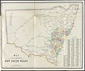
1872 map showing the 19 populated counties

