Stapylton County facts for kids
Quick facts for kids StapyltonNew South Wales |
|||||||||||||||
|---|---|---|---|---|---|---|---|---|---|---|---|---|---|---|---|

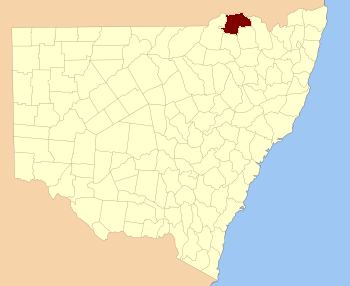
Location in New South Wales
|
|||||||||||||||
|
|||||||||||||||
Stapylton County is one of the 141 special areas called cadastral divisions in New South Wales, Australia. It is located south of the Barwon River. A part of the important Newell Highway also runs through this county.
Stapylton County got its name from a geologist named Granville William Chetwynd Stapylton (1800-1840). He was a scientist who studied rocks and the Earth's history.
What is a County?
In Australia, a county is a type of land division. It helps to organize and describe areas of land. Think of it like a large district or region. These divisions are used for official records and maps. They help people understand where properties are located.
New South Wales has 141 of these counties. They are important for how land is managed across the state.
Parishes within Stapylton County
Counties are often divided into smaller areas called parishes. These parishes are even smaller land units. They help to map out land in more detail.
Stapylton County includes many different parishes. Each parish has its own name and location. These smaller divisions help local governments manage land. They are used for things like property boundaries and planning.
 | Jewel Prestage |
 | Ella Baker |
 | Fannie Lou Hamer |

