Benarba County facts for kids
Quick facts for kids BenarbaNew South Wales |
|||||||||||||||
|---|---|---|---|---|---|---|---|---|---|---|---|---|---|---|---|

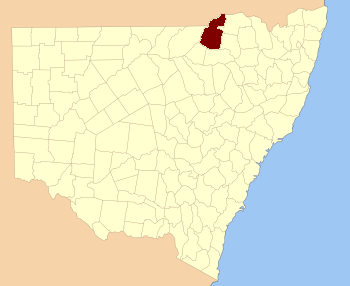
Location in New South Wales
|
|||||||||||||||
|
|||||||||||||||
Benarba County is a special way that land is divided in New South Wales, Australia. It's one of 141 such areas. Think of it like a big, old-fashioned map section. These divisions help people keep track of land for things like property records.
The name Benarba is thought to come from a word used by the local Aboriginal people who lived there long ago.
What is Benarba County?
Benarba County is a type of land division called a cadastral division. This means it's a way of splitting up land for official reasons. It helps with mapping, owning property, and managing land. These counties were created a long time ago. They are still used today for some legal and historical purposes.
Where is Benarba County?
Benarba County is located in New South Wales, a state in Australia. It shares borders with other counties and even with the state of Queensland. This area is part of the larger Moree Plains Shire, which is a local government area.
Parishes in Benarba County
Inside Benarba County, there are many smaller areas called parishes. These are even smaller land divisions. They help to break down the county into more manageable parts. Each parish has its own name and specific location. They are important for understanding how land was historically organized in New South Wales.
 | Ernest Everett Just |
 | Mary Jackson |
 | Emmett Chappelle |
 | Marie Maynard Daly |

