Denham County facts for kids
Quick facts for kids DenhamNew South Wales |
|||||||||||||||
---|---|---|---|---|---|---|---|---|---|---|---|---|---|---|---|
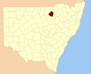
Location in New South Wales
|
|||||||||||||||
|
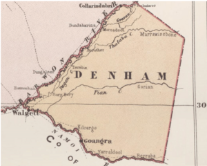
Denham County, is one of the 141 Cadastral divisions of New South Wales. It lies between the Barwon River and the Namoi River, where the two rivers meet. It includes the localities of Koothney, Cryon and Bugilbone.
Denham County was named in honour of Captain H. M. Denham, H.M.S. Herald.
Parishes within this county
A full list of parishes found within this county; their current LGA and mapping coordinates to the approximate centre of each location is as follows:
Parish | LGA | Coordinates |
---|---|---|
Baraneal | Walgett Shire | 30°06′54″S 148°28′04″E / 30.11500°S 148.46778°E |
Barwon | Walgett Shire | 29°41′54″S 148°26′04″E / 29.69833°S 148.43444°E |
Benn | Walgett Shire | 30°03′54″S 148°42′04″E / 30.06500°S 148.70111°E |
Bergan | Walgett Shire | 30°07′54″S 148°34′04″E / 30.13167°S 148.56778°E |
Berryabar | Walgett Shire | 30°13′54″S 148°38′04″E / 30.23167°S 148.63444°E |
Browne | Walgett Shire | 29°43′54″S 148°40′04″E / 29.73167°S 148.66778°E |
Bugilbone | Walgett Shire | 30°13′54″S 148°46′04″E / 30.23167°S 148.76778°E |
Buriembri | Walgett Shire | 29°57′54″S 148°24′04″E / 29.96500°S 148.40111°E |
Cabul | Walgett Shire | 29°48′54″S 148°32′04″E / 29.81500°S 148.53444°E |
Christie | Walgett Shire | 29°42′54″S 148°50′04″E / 29.71500°S 148.83444°E |
Cryon | Walgett Shire | 29°53′54″S 148°37′04″E / 29.89833°S 148.61778°E |
Denham | Walgett Shire | 30°01′54″S 148°24′04″E / 30.03167°S 148.40111°E |
Denuleroi | Walgett Shire | 29°53′54″S 148°24′04″E / 29.89833°S 148.40111°E |
Dewhurst | Walgett Shire | 29°41′54″S 148°40′04″E / 29.69833°S 148.66778°E |
Eastlake | Walgett Shire | 29°59′54″S 148°46′04″E / 29.99833°S 148.76778°E |
Eton | Walgett Shire | 29°48′54″S 148°50′04″E / 29.81500°S 148.83444°E |
Eurie Eurie | Walgett Shire | 29°53′54″S 148°18′04″E / 29.89833°S 148.30111°E |
Finley | Walgett Shire | 29°48′54″S 148°45′04″E / 29.81500°S 148.75111°E |
Glass | Walgett Shire | 29°55′54″S 148°12′04″E / 29.93167°S 148.20111°E |
Gorian | Walgett Shire | 29°52′54″S 148°50′04″E / 29.88167°S 148.83444°E |
Jereel | Walgett Shire | 30°08′54″S 148°39′04″E / 30.14833°S 148.65111°E |
Katambone | Walgett Shire | 30°04′54″S 148°47′04″E / 30.08167°S 148.78444°E |
Long Point | Walgett Shire | 29°35′54″S 148°41′04″E / 29.59833°S 148.68444°E |
Manilla | Walgett Shire | 29°51′54″S 148°20′04″E / 29.86500°S 148.33444°E |
Merrywinebone | Walgett Shire | 29°42′54″S 148°45′04″E / 29.71500°S 148.75111°E |
Mungerarra | Walgett Shire | 29°57′54″S 148°30′04″E / 29.96500°S 148.50111°E |
Murkadool | Walgett Shire | 29°39′54″S 148°33′04″E / 29.66500°S 148.55111°E |
Murra Murra | Walgett Shire | 29°56′54″S 148°47′04″E / 29.94833°S 148.78444°E |
Myall | Walgett Shire | 30°02′54″S 148°31′04″E / 30.04833°S 148.51778°E |
Myallwirrie | Walgett Shire | 30°11′54″S 148°28′04″E / 30.19833°S 148.46778°E |
Pagan | Walgett Shire | 29°49′54″S 148°22′04″E / 29.83167°S 148.36778°E |
Pearse | Walgett Shire | 29°50′54″S 148°39′04″E / 29.84833°S 148.65111°E |
Pian | Walgett Shire | 29°57′54″S 148°18′04″E / 29.96500°S 148.30111°E |
Pokataroo | Walgett Shire | 29°35′54″S 148°34′04″E / 29.59833°S 148.56778°E |
Reynolds | Walgett Shire | 29°59′54″S 148°37′04″E / 29.99833°S 148.61778°E |
Roberts | Walgett Shire | 29°42′54″S 148°33′04″E / 29.71500°S 148.55111°E |
Tareela | Walgett Shire | 30°09′54″S 148°46′04″E / 30.16500°S 148.76778°E |
Terribie | Walgett Shire | 29°49′54″S 148°16′04″E / 29.83167°S 148.26778°E |
Thalaba | Walgett Shire | 29°52′54″S 148°32′04″E / 29.88167°S 148.53444°E |
Tholoo | Walgett Shire | 30°03′54″S 148°35′04″E / 30.06500°S 148.58444°E |
Toryweewha | Walgett Shire | 30°05′54″S 148°24′04″E / 30.09833°S 148.40111°E |
Walgett | Walgett Shire | 29°57′54″S 148°12′04″E / 29.96500°S 148.20111°E |
Walmar | Walgett Shire | 30°03′54″S 148°18′04″E / 30.06500°S 148.30111°E |
Yarraldool | Walgett Shire | 30°15′54″S 148°32′04″E / 30.26500°S 148.53444°E |
All content from Kiddle encyclopedia articles (including the article images and facts) can be freely used under Attribution-ShareAlike license, unless stated otherwise. Cite this article:
Denham County Facts for Kids. Kiddle Encyclopedia.