Baradine County facts for kids
Quick facts for kids BaradineNew South Wales |
|||||||||||||||
|---|---|---|---|---|---|---|---|---|---|---|---|---|---|---|---|

Location in New South Wales
|
|||||||||||||||
|
|||||||||||||||
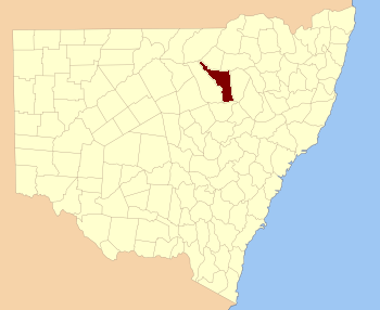
Baradine County is a special kind of land area in New South Wales, Australia. It's one of 141 such areas. Think of it like a historical district or region. This county is located in the central-north part of New South Wales. It stretches from the Namoi River in the north down to the town of Coonabarabran in the south. The county also includes land around Baradine Creek and the town of Baradine. The name 'Baradine' comes from an old word used by the local Aboriginal people.
Contents
What is Baradine County?
Baradine County is a "cadastral division." This is a fancy term for a land area used for mapping and keeping records. These divisions help organize land for things like property ownership. They are not the same as modern local government areas.
Where is Baradine County located?
This county is in the central-north part of New South Wales. It borders the Namoi River in the north. The southern edge of the county reaches the town of Coonabarabran. The county also includes the town of Baradine itself. Baradine Creek flows through the area, with land on both sides belonging to the county.
The name Baradine
The name 'Baradine' has a special meaning. It is believed to come from a word used by the local Aboriginal people. This shows the deep history of the land.
Smaller Areas in Baradine County
Counties like Baradine are often divided into smaller sections. These smaller sections are called parishes. Parishes are like tiny neighborhoods or land blocks within the larger county. They help to further organize the land. Many different parishes make up Baradine County. Each parish has its own name and location.
 | Anna J. Cooper |
 | Mary McLeod Bethune |
 | Lillie Mae Bradford |

