Westmoreland County, New South Wales facts for kids
Quick facts for kids WestmorelandNew South Wales |
|||||||||||||||
|---|---|---|---|---|---|---|---|---|---|---|---|---|---|---|---|

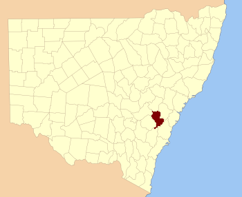
Location in New South Wales
|
|||||||||||||||
|
|||||||||||||||
Westmoreland County is a special kind of land division in New South Wales, Australia. It was one of the first 19 areas officially marked out when the colony was new. These areas helped people keep track of land ownership and where things were located. Today, it is still used as a way to describe land for official records.
This county is located west of Sydney in the beautiful Blue Mountains region. Natural features like rivers form some of its borders. The Coxs River is its northern edge, and the Wollondilly River marks its eastern side. In the northeast, the Campbells River and part of the Fish River help define its boundaries, reaching close to the city of Bathurst. Inside Westmoreland County, you'll find the town of Oberon and the amazing Kanangra-Boyd National Park, which is a huge area of wilderness.
What's in a Name?
How Westmoreland County Got Its Name
Westmoreland County was named to honor a very important person from England. This person was John Fane, who lived from 1759 to 1841. He was the Tenth Earl of Westmorland, which means he held a high noble title. Naming places after important people was a common practice in the early days of the colony.
Early Voting Areas
This area also played a part in the early history of voting in New South Wales. The first state voting area for this region was called the Electoral district of Cook and Westmoreland. An electoral district is a specific area where people vote to choose their representatives in the government. This district existed between 1856 and 1859, showing how Westmoreland County was important even in the early days of Australian democracy.
 | Georgia Louise Harris Brown |
 | Julian Abele |
 | Norma Merrick Sklarek |
 | William Sidney Pittman |

