kids encyclopedia robot

Livingstone County, New South Wales facts for kids

Kids Encyclopedia Facts
Quick facts for kids
Livingstone
New South Wales
Livingstone NSW.PNG
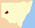
Location in New South Wales
Lands administrative divisions around Livingstone:
Tandora Young Werunda
Menindee Livingstone Woore
Windeyer Perry Manara

Livingstone County is one of the 141 Cadastral divisions of New South Wales. The Darling River is the western and north-western boundary, near Menindee.

Livingstone County was named in honour after the African missionary and explorer David Livingstone (1813-1873).

Parishes within this county

A full list of parishes found within this county; their current LGA and mapping coordinates to the approximate centre of each location is as follows:

Parish LGA Coordinates
Albemarle Central Darling Shire 32°19′13″S 142°39′40″E / 32.32028°S 142.66111°E / -32.32028; 142.66111 (Albemarle)
Arlington Central Darling Shire 32°27′30″S 143°45′32″E / 32.45833°S 143.75889°E / -32.45833; 143.75889 (Arlington)
Ashbourne Central Darling Shire 32°19′46″S 143°23′35″E / 32.32944°S 143.39306°E / -32.32944; 143.39306 (Ashbourne)
Berangabah Central Darling Shire 32°29′45″S 143°31′58″E / 32.49583°S 143.53278°E / -32.49583; 143.53278 (Berangabah)
Billitong Central Darling Shire 32°08′26″S 143°10′52″E / 32.14056°S 143.18111°E / -32.14056; 143.18111 (Billitong)
Bindi Central Darling Shire 32°27′48″S 143°12′01″E / 32.46333°S 143.20028°E / -32.46333; 143.20028 (Bindi)
Blenalben Central Darling Shire 32°22′43″S 143°49′06″E / 32.37861°S 143.81833°E / -32.37861; 143.81833 (Blenalben)
Blenheim Central Darling Shire 32°21′22″S 142°31′28″E / 32.35611°S 142.52444°E / -32.35611; 142.52444 (Blenheim)
Boliva Central Darling Shire 32°38′00″S 142°51′31″E / 32.63333°S 142.85861°E / -32.63333; 142.85861 (Boliva)
Boolaboolka Central Darling Shire 32°36′04″S 143°12′44″E / 32.60111°S 143.21222°E / -32.60111; 143.21222 (Boolaboolka)
Boomery Central Darling Shire 32°16′03″S 143°13′47″E / 32.26750°S 143.22972°E / -32.26750; 143.22972 (Boomery)
Boonditti Central Darling Shire 32°21′29″S 142°56′52″E / 32.35806°S 142.94778°E / -32.35806; 142.94778 (Boonditti)
Boonoona Central Darling Shire 32°38′47″S 143°01′52″E / 32.64639°S 143.03111°E / -32.64639; 143.03111 (Boonoona)
Boothingalla Central Darling Shire 32°11′41″S 143°02′23″E / 32.19472°S 143.03972°E / -32.19472; 143.03972 (Boothingalla)
Brainerd Central Darling Shire 31°59′37″S 143°10′19″E / 31.99361°S 143.17194°E / -31.99361; 143.17194 (Brainerd)
Brunker Central Darling Shire 31°56′48″S 143°04′41″E / 31.94667°S 143.07806°E / -31.94667; 143.07806 (Brunker)
Burndoo Central Darling Shire 32°09′35″S 143°41′52″E / 32.15972°S 143.69778°E / -32.15972; 143.69778 (Burndoo)
Clifford Central Darling Shire 31°52′13″S 143°10′58″E / 31.87028°S 143.18278°E / -31.87028; 143.18278 (Clifford)
Connulpie Central Darling Shire 32°39′58″S 143°22′18″E / 32.66611°S 143.37167°E / -32.66611; 143.37167 (Connulpie)
Conolly Central Darling Shire 32°36′22″S 142°36′31″E / 32.60611°S 142.60861°E / -32.60611; 142.60861 (Conolly)
Coveney Central Darling Shire 32°04′06″S 143°19′15″E / 32.06833°S 143.32083°E / -32.06833; 143.32083 (Coveney)
Cowary Central Darling Shire unknown
Culpaulin Central Darling Shire unknown
Dromore Central Darling Shire 32°23′21″S 143°34′20″E / 32.38917°S 143.57222°E / -32.38917; 143.57222 (Cowary)
Gemini Central Darling Shire 32°24′40″S 142°40′21″E / 32.41111°S 142.67250°E / -32.41111; 142.67250 (Gemini)
Gordon Central Darling Shire 32°25′40″S 142°50′09″E / 32.42778°S 142.83583°E / -32.42778; 142.83583 (Gordon)
Haribel Central Darling Shire 32°00′24″S 143°20′00″E / 32.00667°S 143.33333°E / -32.00667; 143.33333 (Haribel)
Huco Central Darling Shire 32°35′03″S 143°02′22″E / 32.58417°S 143.03944°E / -32.58417; 143.03944 (Huco)
Hudson Central Darling Shire 32°17′53″S 143°44′48″E / 32.29806°S 143.74667°E / -32.29806; 143.74667 (Hudson)
Liddell Central Darling Shire 32°12′38″S 142°43′30″E / 32.21056°S 142.72500°E / -32.21056; 142.72500 (Liddell)
Makingah Central Darling Shire 32°32′52″S 142°37′02″E / 32.54778°S 142.61722°E / -32.54778; 142.61722 (Makingah)
Mandy Central Darling Shire 32°41′50″S 142°45′01″E / 32.69722°S 142.75028°E / -32.69722; 142.75028 (Mandy)
Marlborough Central Darling Shire 31°48′33″S 143°16′31″E / 31.80917°S 143.27528°E / -31.80917; 143.27528 (Marlborough)
Marle Central Darling Shire 32°02′18″S 143°32′31″E / 32.03833°S 143.54194°E / -32.03833; 143.54194 (Marle)
Minden Central Darling Shire 32°09′47″S 143°22′24″E / 32.16306°S 143.37333°E / -32.16306; 143.37333 (Minden)
Mourte Central Darling Shire 32°31′02″S 142°46′30″E / 32.51722°S 142.77500°E / -32.51722; 142.77500 (Mourte)
Mundy Central Darling Shire 32°17′01″S 142°51′56″E / 32.28361°S 142.86556°E / -32.28361; 142.86556 (Mundy)
Newcome Central Darling Shire 32°11′14″S 142°51′16″E / 32.18722°S 142.85444°E / -32.18722; 142.85444 (Newcome)
Pysant Central Darling Shire 32°18′14″S 143°03′13″E / 32.30389°S 143.05361°E / -32.30389; 143.05361 (Pysant)
Repton Central Darling Shire 32°01′13″S 143°01′40″E / 32.02028°S 143.02778°E / -32.02028; 143.02778 (Repton)
Sadlier Central Darling Shire 32°23′27″S 143°03′42″E / 32.39083°S 143.06167°E / -32.39083; 143.06167 (Sadlier)
Steel Central Darling Shire 32°25′11″S 142°30′49″E / 32.41972°S 142.51361°E / -32.41972; 142.51361 (Steel)
Surbiton Central Darling Shire 32°08′45″S 142°53′14″E / 32.14583°S 142.88722°E / -32.14583; 142.88722 (Surbiton)
Talyawalka Central Darling Shire 32°28′57″S 142°27′25″E / 32.48250°S 142.45694°E / -32.48250; 142.45694 (Talyawalka)
Teryawinya Central Darling Shire 32°28′07″S 143°22′21″E / 32.46861°S 143.37250°E / -32.46861; 143.37250 (Teryawinya)
Tintinalogy Central Darling Shire 32°09′12″S 143°02′11″E / 32.15333°S 143.03639°E / -32.15333; 143.03639 (Tintinalogy)
Toorincaca Central Darling Shire 32°32′21″S 142°52′20″E / 32.53917°S 142.87222°E / -32.53917; 142.87222 (Toorincaca)
Undeathi Central Darling Shire 32°31′18″S 142°27′11″E / 32.52167°S 142.45306°E / -32.52167; 142.45306 (Undeathi)
Victoria Central Darling Shire 32°36′24″S 143°24′08″E / 32.60667°S 143.40222°E / -32.60667; 143.40222 (Victoria)
Wambah Central Darling Shire 32°24′38″S 142°25′22″E / 32.41056°S 142.42278°E / -32.41056; 142.42278 (Wambah)
Wanalla Central Darling Shire 32°15′34″S 143°33′20″E / 32.25944°S 143.55556°E / -32.25944; 143.55556 (Wanalla)
Weatherly Central Darling Shire 32°04′56″S 143°09′24″E / 32.08222°S 143.15667°E / -32.08222; 143.15667 (Weatherly)
Widgera Central Darling Shire 32°21′48″S 143°12′55″E / 32.36333°S 143.21528°E / -32.36333; 143.21528 (Widgera)
Yenda Central Darling Shire unknown
kids search engine
Livingstone County, New South Wales Facts for Kids. Kiddle Encyclopedia.