Perry County, New South Wales facts for kids
Quick facts for kids PerryNew South Wales |
|||||||||||||||
|---|---|---|---|---|---|---|---|---|---|---|---|---|---|---|---|

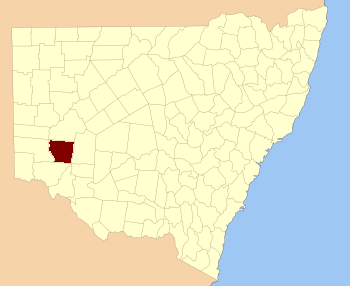
Location in New South Wales
|
|||||||||||||||
|
|||||||||||||||
Perry County is one of 141 special land areas in New South Wales, Australia. These areas are called cadastral divisions. They are used to help map and keep records of land. Perry County is located to the east of the Darling River, close to the town of Pooncarie.
Contents
What is Perry County?
Perry County is like a large, imaginary section of land. It helps people keep track of who owns what land and where it is. These "counties" were created a long time ago. They are still used today for official land records and mapping.
Where is Perry County Located?
Perry County is in the western part of New South Wales. It sits on the eastern side of the Darling River, which is one of Australia's longest rivers. The county is near the small town of Pooncarie. It is surrounded by other counties like Menindee and Wentworth.
Who Was Samuel Augustus Perry?
Perry County was named after a person named Samuel Augustus Perry (1792–1854). He was an important soldier and surveyor. A surveyor is someone who measures and maps land. Samuel Augustus Perry helped map many parts of Australia. Naming a county after him was a way to honor his work.
Parishes: Smaller Areas Within the County
Inside Perry County, there are many smaller sections of land called parishes. Think of them like smaller neighborhoods or districts within a larger area. These parishes also help with land mapping and record-keeping. Each parish has its own name and location. Some of these parishes are managed by the Wentworth Shire local council. Others are part of the Central Darling Shire.
 | Frances Mary Albrier |
 | Whitney Young |
 | Muhammad Ali |

