Canbelego County facts for kids
Quick facts for kids CanbelegoNew South Wales |
|||||||||||||||
|---|---|---|---|---|---|---|---|---|---|---|---|---|---|---|---|

Location in New South Wales
|
|||||||||||||||
|
|||||||||||||||
Canbelego County is a special kind of area in New South Wales, Australia. It's one of 141 "cadastral divisions" in the state. Think of it like an old-fashioned way of dividing land for maps and records. The name Canbelego is thought to come from a word used by the local Indigenous Australians, who are the original people of Australia.
What is Canbelego County?
Canbelego County is a "cadastral division." This is a special term for a land area used for official records. These divisions help people keep track of land ownership and boundaries. They are important for mapping and legal reasons, even today.
How Land is Divided
In New South Wales, Australia, land is divided into different types of areas. Counties are one of the oldest ways this was done. Inside each county, there are smaller areas called "parishes." These parishes are even smaller sections of land.
Canbelego County contains many parishes. Each parish has its own name and location. These smaller divisions help local governments manage the land. They also help when creating detailed maps of the area.
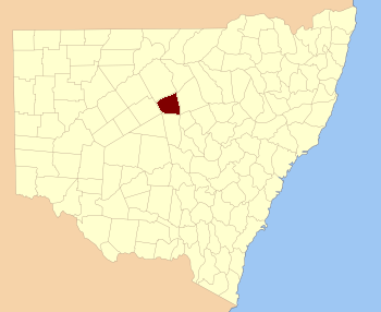
Where is Canbelego County?
Canbelego County is located in New South Wales. It is surrounded by other counties. For example, to the north are Cowper and Clyde Counties. To the south, you'll find Flinders and Mouramba Counties. These neighboring areas help define Canbelego County's place on the map.
 | James B. Knighten |
 | Azellia White |
 | Willa Brown |

