Rous County facts for kids
Quick facts for kids RousNew South Wales |
|||||||||||||||
---|---|---|---|---|---|---|---|---|---|---|---|---|---|---|---|
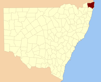
Location in New South Wales
|
|||||||||||||||
|
Rous County is one of the 141 Cadastral divisions of New South Wales. It is located at the north-east tip of the state. It is bordered on the north by the border with Queensland and on the south by the Richmond River. It contains Lismore, Byron Bay and Murwillumbah.
Rous County was named in honour of Admiral Henry John Rous (1795-1877).
Parishes within this county
A full list of parishes found within this county; their current LGA and mapping coordinates to the approximate centre of each location is as follows:
Parish | LGA | Coordinates |
---|---|---|
Babyil | Kyogle Shire | 28°37′54″S 152°45′04″E / 28.63167°S 152.75111°E |
Ballina | Ballina Shire | 28°49′54″S 153°33′04″E / 28.83167°S 153.55111°E |
Berwick | Tweed Shire | 28°13′54″S 153°25′04″E / 28.23167°S 153.41778°E |
Bexhill | City of Lismore | 28°45′54″S 153°22′04″E / 28.76500°S 153.36778°E |
Billinudgel | Tweed Shire | 28°30′54″S 153°30′04″E / 28.51500°S 153.50111°E |
Bingal | Ballina Shire | 28°56′54″S 153°28′04″E / 28.94833°S 153.46778°E |
Blakebrook | City of Lismore | 28°45′54″S 153°16′04″E / 28.76500°S 153.26778°E |
Boorabee | City of Lismore | 28°39′54″S 153°05′04″E / 28.66500°S 153.08444°E |
Broadwater | City of Lismore | 29°00′54″S 153°24′04″E / 29.01500°S 153.40111°E |
Brunswick | Byron Shire | 28°35′54″S 153°31′04″E / 28.59833°S 153.51778°E |
Bungabbee | City of Lismore | 28°43′54″S 153°08′04″E / 28.73167°S 153.13444°E |
Burrell | Kyogle Shire | 28°23′54″S 153°15′04″E / 28.39833°S 153.25111°E |
Byron | Byron Shire | 28°39′54″S 153°32′04″E / 28.66500°S 153.53444°E |
Chillingham | Kyogle Shire | 28°16′54″S 153°13′04″E / 28.28167°S 153.21778°E |
Clunes | City of Lismore | 28°40′54″S 153°25′04″E / 28.68167°S 153.41778°E |
Condong | Tweed Shire | 28°19′54″S 153°27′04″E / 28.33167°S 153.45111°E |
Coraki | City of Lismore | 29°00′54″S 153°19′04″E / 29.01500°S 153.31778°E |
Cougal | Kyogle Shire | 28°22′54″S 152°57′04″E / 28.38167°S 152.95111°E |
Cudgen | Tweed Shire | 28°16′54″S 153°33′04″E / 28.28167°S 153.55111°E |
Dunbible | Tweed Shire | 28°22′54″S 153°23′04″E / 28.38167°S 153.38444°E |
Dunoon | City of Lismore | 28°39′54″S 153°19′04″E / 28.66500°S 153.31778°E |
Dyraaba | Kyogle Shire | 28°47′54″S 152°47′04″E / 28.79833°S 152.78444°E |
East Gundurimba | City of Lismore | 28°51′54″S 153°18′04″E / 28.86500°S 153.30111°E |
Ettrick | Kyogle Shire | 28°34′54″S 152°52′04″E / 28.58167°S 152.86778°E |
Fairy Mount | Kyogle Shire | 28°33′54″S 153°03′04″E / 28.56500°S 153.05111°E |
Findon | Kyogle Shire | 28°22′54″S 152°51′04″E / 28.38167°S 152.85111°E |
Geneva | Kyogle Shire | 28°36′54″S 152°57′04″E / 28.61500°S 152.95111°E |
Gooninbar | Kyogle Shire | 28°29′54″S 153°16′04″E / 28.49833°S 153.26778°E |
Hanging Rock | City of Lismore | 28°31′54″S 153°08′04″E / 28.53167°S 153.13444°E |
Jasper | Byron Shire | 28°36′54″S 153°26′04″E / 28.61500°S 153.43444°E |
Jiggi | City of Lismore | 28°36′54″S 153°08′04″E / 28.61500°S 153.13444°E |
Kunghur | Tweed Shire | 28°27′54″S 153°12′04″E / 28.46500°S 153.20111°E |
Kynnumboon | Tweed Shire | 28°16′54″S 153°20′04″E / 28.28167°S 153.33444°E |
Kyogle Shire | Richmond Valley Council | 28°45′54″S 153°00′04″E / 28.76500°S 153.00111°E |
Langwell | Kyogle Shire | 28°38′54″S 152°51′04″E / 28.64833°S 152.85111°E |
Lismore | City of Lismore | 28°49′54″S 153°23′04″E / 28.83167°S 153.38444°E |
Loadstone | Kyogle Shire | 28°25′54″S 152°57′04″E / 28.43167°S 152.95111°E |
Meerschaum | Ballina Shire | 28°53′54″S 153°24′04″E / 28.89833°S 153.40111°E |
Mooball | Tweed Shire | 28°24′54″S 153°29′04″E / 28.41500°S 153.48444°E |
Mullumbimby | Byron Shire | 28°31′54″S 153°26′04″E / 28.53167°S 153.43444°E |
Mummulgum | Kyogle Shire | 28°52′54″S 152°47′04″E / 28.88167°S 152.78444°E |
Murwillumbah | Tweed Shire | 28°19′54″S 153°17′04″E / 28.33167°S 153.28444°E |
Newrybar | Ballina Shire | 28°44′54″S 153°33′04″E / 28.74833°S 153.55111°E |
Nimbin | City of Lismore | 28°37′54″S 153°14′04″E / 28.63167°S 153.23444°E |
North Casino | Richmond Valley Council | 28°46′54″S 153°04′04″E / 28.78167°S 153.06778°E |
North Codrington | City of Lismore | 28°55′54″S 153°15′04″E / 28.93167°S 153.25111°E |
North Lismore | City of Lismore | 28°44′54″S 153°18′04″E / 28.74833°S 153.30111°E |
Nullum | Tweed Shire | 28°26′54″S 153°22′04″E / 28.44833°S 153.36778°E |
Pimlico | Ballina Shire | 28°53′54″S 153°30′04″E / 28.89833°S 153.50111°E |
Queebun | Kyogle Shire | 28°44′54″S 152°51′04″E / 28.74833°S 152.85111°E |
Roseberry | Kyogle Shire | 28°29′54″S 152°52′04″E / 28.49833°S 152.86778°E |
Runnymede | Kyogle Shire | 28°39′54″S 153°02′04″E / 28.66500°S 153.03444°E |
Runnymede | Kyogle Shire | 28°40′54″S 153°00′04″E / 28.68167°S 153.00111°E |
Sherwood | Kyogle Shire | 28°28′54″S 152°46′04″E / 28.48167°S 152.76778°E |
South Gundurimba | City of Lismore | 28°51′54″S 153°13′04″E / 28.86500°S 153.21778°E |
South Lismore | City of Lismore | 28°48′54″S 153°15′04″E / 28.81500°S 153.25111°E |
Stratheden | Kyogle Shire | 28°44′54″S 152°57′04″E / 28.74833°S 152.95111°E |
Terania | City of Lismore | 28°33′54″S 153°15′04″E / 28.56500°S 153.25111°E |
Terranora | Tweed Shire | 28°12′54″S 153°30′04″E / 28.21500°S 153.50111°E |
Teven | Byron Shire | 28°45′54″S 153°32′04″E / 28.76500°S 153.53444°E |
Tomki | Richmond Valley Council | 28°49′54″S 153°08′04″E / 28.83167°S 153.13444°E |
Toolond | Tweed Shire | 28°31′54″S 153°21′04″E / 28.53167°S 153.35111°E |
Toonumbar | Kyogle Shire | 28°32′54″S 152°46′04″E / 28.54833°S 152.76778°E |
Tuckombil | Ballina Shire | 28°49′54″S 153°28′04″E / 28.83167°S 153.46778°E |
Tuckurimba | City of Lismore | 28°55′54″S 153°19′04″E / 28.93167°S 153.31778°E |
Tunstall | City of Lismore | 28°41′54″S 153°14′04″E / 28.69833°S 153.23444°E |
Tyalgum | Tweed Shire | 28°22′54″S 153°09′04″E / 28.38167°S 153.15111°E |
Tygalgah | Tweed Shire | 28°18′54″S 153°25′04″E / 28.31500°S 153.41778°E |
Unumgar | Kyogle Shire | 28°22′54″S 152°45′04″E / 28.38167°S 152.75111°E |
Warrazambil | Kyogle Shire | 28°29′54″S 153°04′04″E / 28.49833°S 153.06778°E |
Whian Whian | City of Lismore | 28°35′54″S 153°20′04″E / 28.59833°S 153.33444°E |
Wiangaree | Kyogle Shire | 28°33′54″S 153°00′04″E / 28.56500°S 153.00111°E |
Wollumbin | Tweed Shire | 28°22′54″S 153°19′04″E / 28.38167°S 153.31778°E |
Worendo | Kyogle Shire | 28°22′54″S 153°04′04″E / 28.38167°S 153.06778°E |
Wyndham | Kyogle Shire | 28°30′54″S 152°56′04″E / 28.51500°S 152.93444°E |
Dunoon dam proposal
The council, which is the authority responsible for the water supply for most of the Ballina, Byron, Lismore and Richmond Valley council areas, published its draft water strategy in June 2020, which includes a 50-gigalitre (1.8×10⁹ cu ft) dam at Dunoon about 20 kilometres (12 mi) north of Lismore. The council has been aware of Indigenous concerns since the matter was first considered in the 1990s, and was committed to working with local communities to mitigate concerns. An impact assessment of the site had identified various artefacts and burial sites in the area.