
Murwillumbah facts for kids
Quick facts for kids MurwillumbahNew South Wales |
|||||||||||||||
|---|---|---|---|---|---|---|---|---|---|---|---|---|---|---|---|

Partial view of town and Tweed River, 2008
|
|||||||||||||||

Murwillumbah
Location in New South Wales
|
|||||||||||||||
| Population | 9,812 (2021 census) | ||||||||||||||
| Postcode(s) | 2484 | ||||||||||||||
| Elevation | 8 m (26 ft) | ||||||||||||||
| Location |
|
||||||||||||||
| LGA(s) | Tweed Shire | ||||||||||||||
| County | Rous | ||||||||||||||
| State electorate(s) | Lismore | ||||||||||||||
| Federal Division(s) | Richmond | ||||||||||||||
|
|||||||||||||||
|
|||||||||||||||
Murwillumbah (/mərˈwɪləmbɑː/ MƏR-wil-ƏM-bah) is a town in the Northern Rivers region of New South Wales, Australia. It is located in the Tweed Shire, right on the Tweed River. The town sits at the base of the McPherson Range in the Tweed Volcano valley.
Murwillumbah is about 848 km north-east of Sydney and 132 km south of Brisbane. It is also only 13 km south of the Queensland border. People often call the town M'bah or Murbah for short. In 2021, about 9,812 people lived there. Many buildings in Murwillumbah have a cool Art Deco style. You can find cafes, clothes shops, and antique shops in town.
Contents
History of Murwillumbah

The first people to live in this area were the Kalibai people. The name Murwillumbah might come from an Aboriginal phrase. It could mean "camping place" or "big possum place." Nearby Mount Warning is known as Wollumbin, which means "Cloud Catcher" in the Bundjalung language.
In the 1840s, people who cut timber came to the region. The river port at Tumbulgum was the main settlement at first. In 1902, Murwillumbah became the center of its own local government area.
A big fire destroyed most of the town's business area in 1907. In November 2023, fire ants were found in Murwillumbah. This was the first time they were seen outside of South East Queensland since 2001.
Understanding Floods in Murwillumbah
Murwillumbah is protected by special walls called levees. However, these levees do not protect all parts of the town during very large floods. The worst floods happened in 2017 and 2022.
On March 30, 2017, the Tweed River rose to 6.2 meters. This happened after more than 700 mm of rain fell from Tropical Cyclone Debbie. Many people had to leave their homes, especially in South Murwillumbah. Roads were cut off, but the levees just managed to hold back the water from the main town center.
In January 2008, Murwillumbah also had severe flooding. More evacuations happened in May 2009 due to heavy rain. The floods in 2022 were the worst ever recorded. Much of Murwillumbah was covered in water, even more than in 2017.
Historic Places
Murwillumbah has several places that are important for their history. These are called heritage-listed sites. One example is the Murwillumbah railway station in South Murwillumbah. This station was part of the Casino-Murwillumbah railway line. Today, it is the start of the Northern Rivers Rail Trail, a path for walking and cycling.
Getting Around Murwillumbah

The Pacific Highway used to go through South Murwillumbah. But in 2002, a new bypass was built. Now, the old highway is called The Tweed Valley Way. This is the main road to get to Murwillumbah from both the north and the south.
A scenic road heads north-west through the Numinbah Valley. It passes through towns like Chillingham and Natural Bridge. Another road goes south-west to Kyogle, passing near Uki and Nimbin.
The Murwillumbah railway station was once the end of the train line from Casino. Trains used to run daily to Sydney until the line closed in 2004. Now, NSW TrainLink buses connect passengers to Casino for trips to Sydney. The old station building is now a tourist information center.
Several bus companies serve the area. Murwillumbah Bus Company has regular services within the town and to nearby places like Condong and Uki. Other services connect to Pottsville, Cabarita Beach, Nimbin, Chillingham, and Tweed Heads.
Murwillumbah also has a small airfield called Whittle Field. It is named after a local World War II pilot, Bob Whittle. There are no regular flights, but it is used by the Murwillumbah Aero Club. It also supports businesses like crop-dusting and scenic flights.
Local Industries

Besides tourism, the main industry in Murwillumbah is growing sugarcane. The sugar mill in nearby Condong used to have many small train lines to carry the cane. These were stopped in 1973 when machines started harvesting the cane.
There is also some dairy farming in the area. Farmers also grow coffee, bananas, and other tropical fruits and vegetables. South Murwillumbah is home to a brewery called Stone & Wood Brewing Co., which opened in 2014.
Some alternative lifestyle communities are also located nearby. This includes a center for the Hare Krishna group.
Fun Festivals
Murwillumbah hosts the annual Tweed Banana Festival. This is the second oldest festival in Australia. In 2005, the festival celebrated its 50th birthday!
From 2002 to 2009, Murwillumbah had a historic motor racing festival. It was called Speed on Tweed. The event included a parade and a one-kilometer hillclimb course. It attracted thousands of people and cars from all over Australia and even other countries. In 2009, it was held with Rally Australia.
People of Murwillumbah
| Historical population | ||
|---|---|---|
| Year | Pop. | ±% |
| 1921 | 2,861 | — |
| 1933 | 3,895 | +36.1% |
| 1947 | 4,954 | +27.2% |
| 1954 | 6,748 | +36.2% |
| 1961 | 7,151 | +6.0% |
| 1966 | 7,311 | +2.2% |
| 1971 | 7,387 | +1.0% |
| 1976 | 7,294 | −1.3% |
| 1981 | 7,807 | +7.0% |
| 1986 | 7,678 | −1.7% |
| 1991 | 8,003 | +4.2% |
| 1996 | 7,657 | −4.3% |
| 2001 | 7,543 | −1.5% |
| 2006 | 7,952 | +5.4% |
| 2011 | 8,523 | +7.2% |
| 2016 | 9,245 | +8.5% |
| 2021 | 9,812 | +6.1% |
| Source: Australian Bureau of Statistics data. | ||
In the 2021 census, Murwillumbah had 9,812 people. About 52.5% were female and 47.5% were male. The average age was 46 years, which is a bit older than the national average of 38. Most people (81.0%) living in Murwillumbah were born in Australia. Other countries of birth included England (3.4%) and New Zealand (2.0%). Most people (87.7%) spoke only English at home.
Climate and Weather
Murwillumbah has a humid subtropical climate. This means it has hot, wet summers and mild, drier winters.
| Climate data for Murwillumbah (Bray Park) (28º20'S, 153º23'E, 8 m AMSL) (1972-2024 normals and extremes) | |||||||||||||
|---|---|---|---|---|---|---|---|---|---|---|---|---|---|
| Month | Jan | Feb | Mar | Apr | May | Jun | Jul | Aug | Sep | Oct | Nov | Dec | Year |
| Record high °C (°F) | 42.9 (109.2) |
40.9 (105.6) |
36.5 (97.7) |
35.4 (95.7) |
31.9 (89.4) |
27.8 (82.0) |
29.5 (85.1) |
35.9 (96.6) |
37.4 (99.3) |
38.2 (100.8) |
39.6 (103.3) |
40.8 (105.4) |
42.9 (109.2) |
| Mean daily maximum °C (°F) | 29.6 (85.3) |
29.0 (84.2) |
28.2 (82.8) |
26.2 (79.2) |
23.6 (74.5) |
21.3 (70.3) |
21.1 (70.0) |
22.6 (72.7) |
25.2 (77.4) |
26.4 (79.5) |
27.7 (81.9) |
29.1 (84.4) |
25.8 (78.5) |
| Mean daily minimum °C (°F) | 19.8 (67.6) |
19.7 (67.5) |
18.5 (65.3) |
15.6 (60.1) |
12.5 (54.5) |
9.9 (49.8) |
8.6 (47.5) |
8.8 (47.8) |
11.5 (52.7) |
14.2 (57.6) |
16.7 (62.1) |
18.6 (65.5) |
14.5 (58.2) |
| Record low °C (°F) | 13.2 (55.8) |
13.8 (56.8) |
11.5 (52.7) |
6.6 (43.9) |
2.2 (36.0) |
−0.3 (31.5) |
0.2 (32.4) |
−1.4 (29.5) |
3.2 (37.8) |
4.1 (39.4) |
6.6 (43.9) |
10.6 (51.1) |
−1.4 (29.5) |
| Average rainfall mm (inches) | 212.8 (8.38) |
229.5 (9.04) |
211.7 (8.33) |
149.3 (5.88) |
126.9 (5.00) |
101.5 (4.00) |
64.0 (2.52) |
51.1 (2.01) |
39.2 (1.54) |
108.2 (4.26) |
118.2 (4.65) |
172.5 (6.79) |
1,581.1 (62.25) |
| Average rainy days (≥ 1.0 mm) | 12.1 | 13.0 | 13.6 | 10.4 | 9.5 | 7.1 | 5.9 | 5.1 | 5.3 | 8.1 | 9.4 | 10.7 | 110.2 |
| Average afternoon relative humidity (%) | 62 | 65 | 64 | 63 | 61 | 59 | 53 | 50 | 51 | 56 | 59 | 60 | 59 |
| Average dew point °C (°F) | 20.2 (68.4) |
20.2 (68.4) |
18.7 (65.7) |
16.4 (61.5) |
13.6 (56.5) |
11.1 (52.0) |
9.4 (48.9) |
9.7 (49.5) |
12.0 (53.6) |
14.5 (58.1) |
16.8 (62.2) |
18.6 (65.5) |
15.1 (59.2) |
| Source: Bureau of Meteorology (1972-2024 normals and extremes) | |||||||||||||
Schools in Murwillumbah
Murwillumbah has many schools for different age groups.
Primary Schools
- Hare Krishna School
- Mt St Patrick Primary School
- Murwillumbah East Primary School
- Sathya Sai School
- South Murwillumbah's Infants School
- St Joseph's Primary School
- Murwillumbah Primary School
- Tweed Valley Adventist College
Secondary Schools
- Hare Krishna School
- Mount Saint Patrick College
- Murwillumbah High School
- Sathya Sai School
- Wollumbin High School
- Tweed Valley Adventist College
Sports and Fun Activities
Murwillumbah has many sports clubs for you to join. These include:
- Murwillumbah Mustangs (rugby league)
- Murwillumbah SC (soccer)
- The Gentlemen of Murwillumbah Rugby Club (rugby union)
- Golf
- Rowing
- Cricket
- Lawn bowls
- Cycling
Murwillumbah in Movies and TV
Murwillumbah has been a filming location for several movies and TV shows.
- The film Lou (2010), starring John Hurt, was filmed here.
- The ABC TV series Pastures of the Blue Crane was filmed in the Tweed region in 1969.
- In 2018, the town was used for the Netflix show Lunatics (2019), starring Chris Lilley.
- The town is also close to where the British reality TV show I'm A Celebrity...Get Me Out Of Here is filmed. It serves as a base for the show's staff and crew.
Famous People from Murwillumbah
Many well-known people have come from Murwillumbah. Some of them include:
- Doug Anthony (1929–2020), an Australian politician
- Stephanie Gilmore (born 1988), a famous Australian surfer with eight world titles
- John Hargreaves (1945–1996), an Australian actor
- Anthony Laffranchi (born 1980), an Australian National Rugby League player
- Eric Willis (1922–1999), who was the 34th Premier of New South Wales
Images for kids
-
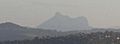
View of Mount Warning
-
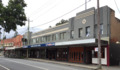
Main Street
-
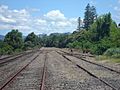
Abandoned train lines
-
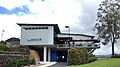
Nearby Tweed Regional Gallery
.jpg)

