Richmond County, New South Wales facts for kids
Quick facts for kids RichmondNew South Wales |
|||||||||||||||
|---|---|---|---|---|---|---|---|---|---|---|---|---|---|---|---|

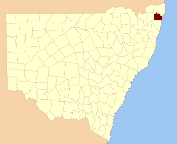
Location in New South Wales
|
|||||||||||||||
|
|||||||||||||||
Richmond County is a special area in New South Wales, Australia. It's one of 141 "cadastral divisions." Think of these as old-fashioned land maps or property zones. This county is located south of the Richmond River. It also includes a part of the town called Casino.
The county got its name from a famous person, Charles Gordon Lennox. He was the Fifth Duke of Richmond, born in 1791 and passing away in 1860. He was an important figure in British history.
What are Cadastral Divisions?
Cadastral divisions are like big sections of land. They were created a long time ago to help organize and keep track of land ownership. This system helps governments manage land for things like taxes and planning.
Where is Richmond County Located?
Richmond County is in the northern part of New South Wales. It's close to the coast and the Pacific Ocean. The county borders other areas like Buller and Rous to the north. To the south, it touches Clarence.
Parishes within Richmond County
Richmond County is divided into smaller areas called parishes. These parishes are like local neighborhoods or districts within the larger county. Each parish has its own name and is part of a local government area (LGA).
Here is a list of the parishes you can find in Richmond County:
| Parish | Local Government Area (LGA) | Coordinates |
|---|---|---|
| Barrawanga | Richmond Valley Council | 29°09′54″S 153°06′04″E / 29.16500°S 153.10111°E |
| Bundock | Richmond Valley Council | 28°50′54″S 152°56′04″E / 28.84833°S 152.93444°E |
| Bungawalbin | Richmond Valley Council | 29°04′54″S 153°17′04″E / 29.08167°S 153.28444°E |
| Busby | Richmond Valley Council | 28°59′54″S 152°48′04″E / 28.99833°S 152.80111°E |
| Camira | Clarence Valley Council | 29°15′54″S 152°56′04″E / 29.26500°S 152.93444°E |
| Coombell | Richmond Valley Council | 28°59′54″S 152°58′04″E / 28.99833°S 152.96778°E |
| Darke | Richmond Valley Council | 29°07′54″S 153°05′04″E / 29.13167°S 153.08444°E |
| Dobie | Clarence Valley Council | 29°10′54″S 152°49′04″E / 29.18167°S 152.81778°E |
| Donaldson | Richmond Valley Council | 29°07′54″S 153°14′04″E / 29.13167°S 153.23444°E |
| Doubleduke | Richmond Valley Council | 29°10′54″S 153°16′04″E / 29.18167°S 153.26778°E |
| East Casino | Richmond Valley Council | 28°53′54″S 153°07′04″E / 28.89833°S 153.11778°E |
| Ellangowan | Richmond Valley Council | 29°00′54″S 153°08′04″E / 29.01500°S 153.13444°E |
| Esk | Richmond Valley Council | 29°13′54″S 153°21′04″E / 29.23167°S 153.35111°E |
| Evans | Richmond Valley Council | 29°09′54″S 153°22′04″E / 29.16500°S 153.36778°E |
| Gibberagee | Richmond Valley Council | 29°14′54″S 153°09′04″E / 29.24833°S 153.15111°E |
| Hogarth | Richmond Valley Council | 29°01′54″S 152°53′04″E / 29.03167°S 152.88444°E |
| Marsh | Clarence Valley Council | 29°15′54″S 152°51′04″E / 29.26500°S 152.85111°E |
| Mongogarie | Richmond Valley Council | 28°56′54″S 152°50′04″E / 28.94833°S 152.83444°E |
| Myall | Richmond Valley Council | 29°17′54″S 153°01′04″E / 29.29833°S 153.01778°E |
| Myrtle | Clarence Valley Council | 29°07′54″S 152°59′04″E / 29.13167°S 152.98444°E |
| Nandabah | Richmond Valley Council | 29°03′54″S 152°58′04″E / 29.06500°S 152.96778°E |
| Powerpa | Clarence Valley Council | 29°12′54″S 152°56′04″E / 29.21500°S 152.93444°E |
| Richmond | Richmond Valley Council | 28°58′54″S 153°04′04″E / 28.98167°S 153.06778°E |
| Riley | Richmond Valley Council | 29°01′54″S 153°28′04″E / 29.03167°S 153.46778°E |
| Shannon | Richmond Valley Council | 28°53′54″S 152°54′04″E / 28.89833°S 152.90111°E |
| South Ballina | Ballina Shire | 28°55′54″S 153°31′04″E / 28.93167°S 153.51778°E |
| South Casino | Richmond Valley Council | 28°53′54″S 153°03′04″E / 28.89833°S 153.05111°E |
| South Codrington | Richmond Valley Council | 28°56′54″S 153°15′04″E / 28.94833°S 153.25111°E |
| Tabbimoble | Richmond Valley Council | 29°15′54″S 153°16′04″E / 29.26500°S 153.26778°E |
| Tatham | Richmond Valley Council | 28°56′54″S 153°11′04″E / 28.94833°S 153.18444°E |
| West Coraki | Richmond Valley Council | 29°01′54″S 153°14′04″E / 29.03167°S 153.23444°E |
| Whiporie | Richmond Valley Council | 29°14′54″S 153°03′04″E / 29.24833°S 153.05111°E |
| Wooroowoolgan | Richmond Valley Council | 28°52′54″S 153°00′04″E / 28.88167°S 153.00111°E |
| Woram | Richmond Valley Council | 28°55′54″S 153°08′04″E / 28.93167°S 153.13444°E |
| Wyandah | Clarence Valley Council | 29°07′54″S 152°50′04″E / 29.13167°S 152.83444°E |
| Wyon | Richmond Valley Council | 29°04′54″S 152°46′04″E / 29.08167°S 152.76778°E |
 | Claudette Colvin |
 | Myrlie Evers-Williams |
 | Alberta Odell Jones |

