
Denison County facts for kids
Quick facts for kids DenisonNew South Wales |
|||||||||||||||
|---|---|---|---|---|---|---|---|---|---|---|---|---|---|---|---|

Location in New South Wales
|
|||||||||||||||
|
|||||||||||||||
Denison County is a special kind of area in New South Wales, Australia. It's like a historical land division, used for keeping track of property and land ownership. Inside Denison County, you'll find the towns of Barooga and Berrigan.
This county was named after a very important person, Sir William Thomas Denison. He was the Governor-General of New South Wales a long time ago, from 1804 to 1871.
Contents
What is Denison County?
Denison County is one of 141 special land areas in New South Wales. These areas are called "cadastral divisions." Think of them as old-fashioned ways to divide up land. They help with things like property records and mapping. Even today, they are part of how land is officially described.
Who was Sir William Denison?
Denison County was named to honor Sir William Thomas Denison. He was a very important leader in Australia's history. Sir William served as the Governor-General of New South Wales from 1804 to 1871.
Smaller Areas Inside
Just like countries are divided into states, counties are divided into smaller sections. These smaller sections are called parishes. Denison County contains many parishes, each with its own name and location. These smaller divisions help local governments manage land and services.
Towns in Denison County
Denison County is home to a couple of interesting towns:
- Barooga: This town is located right on the border with Victoria. It's known for its beautiful river scenery.
- Berrigan: This town is a bit further north. It's a central hub for the surrounding farming communities.
Images for kids
-
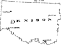
Denison County as shown on a John Sands map from 1886.
.png)
