kids encyclopedia robot

Franklin County, New South Wales facts for kids

Kids Encyclopedia Facts
Quick facts for kids
Franklin
New South Wales
Franklin NSW.PNG
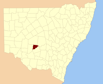
Location in New South Wales
Lands administrative divisions around Franklin:
Mossgiel Mossgiel Blaxland
Waljeers Franklin Dowling
Waljeers Nicholson Nicholson

Franklin County is one of the 141 Cadastral divisions of New South Wales. It lies between Waverley Creek and the Lachlan River, in the area to the north-west of Hillston.

Franklin County was named in honour of the Arctic explorer, Rear Admiral, and Lieutenant-Governor Sir John Franklin (1786-1847).

Parishes within this county

A full list of parishes found within this county; their current LGA and mapping coordinates to the approximate centre of each location is as follows:

Franklin County in John Sands 1886 map
Map of Franklin County from John Sands 1886 map.
Parish LGA Coordinates
Audrey Carrathool Shire Council 33°31′11″S 144°56′52″E / 33.51972°S 144.94778°E / -33.51972; 144.94778 (Audrey)
Baeda Carrathool Shire Council 33°26′45″S 145°12′39″E / 33.44583°S 145.21083°E / -33.44583; 145.21083 (Baeda)
Bellatherie Carrathool Shire Council 33°19′35″S 145°22′44″E / 33.32639°S 145.37889°E / -33.32639; 145.37889 (Bellatherie)
Beremagaa Carrathool Shire Council 33°14′05″S 145°24′48″E / 33.23472°S 145.41333°E / -33.23472; 145.41333 (Beremagaa)
Bundunglong Carrathool Shire Council 33°12′44″S 145°06′36″E / 33.21222°S 145.11000°E / -33.21222; 145.11000 (Bundunglong)
Caaba Carrathool Shire Council 33°39′40″S 145°08′06″E / 33.66111°S 145.13500°E / -33.66111; 145.13500 (Caaba)
Clutha Carrathool Shire Council 33°38′10″S 145°00′02″E / 33.63611°S 145.00056°E / -33.63611; 145.00056 (Clutha)
Embagga Carrathool Shire Council 33°25′04″S 145°28′19″E / 33.41778°S 145.47194°E / -33.41778; 145.47194 (Embagga)
Florabel Carrathool Shire Council 33°28′12″S 145°16′28″E / 33.47000°S 145.27444°E / -33.47000; 145.27444 (Florabel)
Golgothrie Carrathool Shire Council 33°33′09″S 145°01′40″E / 33.55250°S 145.02778°E / -33.55250; 145.02778 (Golgothrie)
Gonowlia Carrathool Shire Council 33°21′05″S 145°36′11″E / 33.35139°S 145.60306°E / -33.35139; 145.60306 (Gonowlia)
Goolagunni Carrathool Shire Council 33°14′52″S 145°34′17″E / 33.24778°S 145.57139°E / -33.24778; 145.57139 (Goolagunni)
Hadyn Carrathool Shire Council 33°25′21″S 145°22′27″E / 33.42250°S 145.37417°E / -33.42250; 145.37417 (Hadyn)
Ideraway Carrathool Shire Council 33°41′13″S 144°56′40″E / 33.68694°S 144.94444°E / -33.68694; 144.94444 (Ideraway)
Ini Carrathool Shire Council 33°36′52″S 145°15′57″E / 33.61444°S 145.26583°E / -33.61444; 145.26583 (Ini)
Kendal Carrathool Shire Council 33°25′26″S 145°07′54″E / 33.42389°S 145.13167°E / -33.42389; 145.13167 (Kendal)
kirindi Carrathool Shire Council 33°33′40″S 144°52′05″E / 33.56111°S 144.86806°E / -33.56111; 144.86806 (Kirindi)
Kongong Carrathool Shire Council 33°19′10″S 145°29′02″E / 33.31944°S 145.48389°E / -33.31944; 145.48389 (Kongong)
Lalla Carrathool Shire Council 33°21′51″S 144°52′46″E / 33.36417°S 144.87944°E / -33.36417; 144.87944 (Lallal)
Marowie Carrathool Shire Council 33°27′20″S 145°29′04″E / 33.45556°S 145.48444°E / -33.45556; 145.48444 (Marowie)
Merungle Carrathool Shire Council 33°36′09″S 144°55′36″E / 33.60250°S 144.92667°E / -33.60250; 144.92667 (Merungle)
Merv Carrathool Shire Council 33°21′41″S 145°18′39″E / 33.36139°S 145.31083°E / -33.36139; 145.31083 (Merv)
Molesworth Carrathool Shire Council unknown
Moolborg Carrathool Shire Council 33°20′58″S 144°58′13″E / 33.34944°S 144.97028°E / -33.34944; 144.97028 (Moolbong)
Myamyn Carrathool Shire Council 33°22′57″S 145°03′38″E / 33.38250°S 145.06056°E / -33.38250; 145.06056 (Myamyn)
Narralin Carrathool Shire Council 33°18′59″S 145°38′49″E / 33.31639°S 145.64694°E / -33.31639; 145.64694 (Narralin)
Nellywanna Carrathool Shire Council 33°25′27″S 145°31′48″E / 33.42417°S 145.53000°E / -33.42417; 145.53000 (Nellywanna)
Papekura Carrathool Shire Council 33°12′28″S 145°00′27″E / 33.20778°S 145.00750°E / -33.20778; 145.00750 (Papekura)
Poli Carrathool Shire Council 33°28′57″S 145°01′24″E / 33.48250°S 145.02333°E / -33.48250; 145.02333 (Poli)
Roeta Carrathool Shire Council 33°17′27″S 144°57′59″E / 33.29083°S 144.96639°E / -33.29083; 144.96639 (Roeta)
Saburra Carrathool Shire Council 33°35′32″S 145°06′43″E / 33.59222°S 145.11194°E / -33.59222; 145.11194 (Saburra)
Terry Carrathool Shire Council 33°14′43″S 145°29′47″E / 33.24528°S 145.49639°E / -33.24528; 145.49639 (Terry)
Thononga Hay Shire Council 33°46′21″S 144°54′03″E / 33.77250°S 144.90083°E / -33.77250; 144.90083 (Thononga)
Tooloor Carrathool Shire Council 33°15′19″S 145°18′52″E / 33.25528°S 145.31444°E / -33.25528; 145.31444 (Tooloor)
Urugalah Carrathool Shire Council 33°17′26″S 145°14′47″E / 33.29056°S 145.24639°E / -33.29056; 145.24639 (Urugalah)
Vieta parish Carrathool Shire Council 33°27′34″S 145°05′58″E / 33.45944°S 145.09944°E / -33.45944; 145.09944 (Vieta)
Warragoodinia Carrathool Shire Council 33°22′17″S 145°22′53″E / 33.37139°S 145.38139°E / -33.37139; 145.38139 (Warragoodinia)
Wheelbah Carrathool Shire Council 33°39′32″S 145°13′12″E / 33.65889°S 145.22000°E / -33.65889; 145.22000 (Whealbah)
Wirringa Carrathool Shire Council 33°12′58″S 144°54′57″E / 33.21611°S 144.91583°E / -33.21611; 144.91583 (Wirringa)
Wogonga Carrathool Shire Council 33°30′45″S 145°18′57″E / 33.51250°S 145.31583°E / -33.51250; 145.31583 (Wogonga)
Wyadra Carrathool Shire Council 33°30′06″S 145°24′36″E / 33.50167°S 145.41000°E / -33.50167; 145.41000 (Wyadra)
Wyuna Carrathool Shire Council 33°16′15″S 145°06′49″E / 33.27083°S 145.11361°E / -33.27083; 145.11361 (Wyuna)
Yandembah Carrathool Shire Council 33°29′56″S 144°52′43″E / 33.49889°S 144.87861°E / -33.49889; 144.87861 (Yandembah)
Yaree Carrathool Shire Council 33°13′36″S 145°12′40″E / 33.22667°S 145.21111°E / -33.22667; 145.21111 (Yaree)
kids search engine
Franklin County, New South Wales Facts for Kids. Kiddle Encyclopedia.