Tongowoko County facts for kids
Quick facts for kids TongowokoNew South Wales |
|||||||||||||||
|---|---|---|---|---|---|---|---|---|---|---|---|---|---|---|---|

Location in New South Wales
|
|||||||||||||||
|
|||||||||||||||
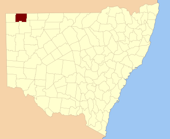
Tongowoko County is a special area of land in the far northwest of New South Wales, Australia. It's located right next to the border with Queensland. This county is one of 141 "cadastral divisions" in New South Wales. Think of a cadastral division as a way to officially divide land for things like property records and mapping.
The name "Tongowoko" comes from a word used by the local Indigenous Australians, who are the original people of Australia.
What Are Cadastral Divisions?
Cadastral divisions are like big, invisible sections of land. They help people keep track of property and boundaries. In New South Wales, these divisions include counties, which are then split into smaller areas called parishes.
How Tongowoko County Is Divided
Tongowoko County is divided into many smaller parts called parishes. These parishes are used for mapping and land management. All the parishes in Tongowoko County are in an "Unincorporated" area. This means they are not part of a local council like a city or shire.
Here are a few examples of parishes you can find in Tongowoko County:
- Binaroo
- Bolwarry
- Calathunda
- Caryapundy
- Mount Wood
Land Management in the Region
Since 2009, the parishes of Tongowoko County have been part of a larger area called Division A of the Western Livestock Health and Pest District. This district helps manage the health of farm animals and control pests in the region. It includes Tongowoko and several other counties in western New South Wales.
 | Claudette Colvin |
 | Myrlie Evers-Williams |
 | Alberta Odell Jones |

