kids encyclopedia robot

Monteagle County facts for kids

Kids Encyclopedia Facts
Quick facts for kids
Monteagle
New South Wales
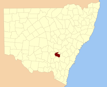
Monteagle NSW.PNG
Location in New South Wales
Lands administrative divisions around Monteagle:
Bland Forbes Bathurst
Bland Monteagle King
Harden Harden King

Monteagle County is one of the 141 Cadastral divisions of New South Wales.

Monteagle County was named in honour of Thomas Spring Rice, 1st Baron Monteagle of Brandon (1790-1866), a former Chancellor of the Exchequer.

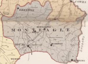
Parishes within this county

A full list of parishes found within this county; their current LGA and mapping coordinates to the approximate centre of each location is as follows:

Parish LGA Coordinates
Baxter Young Shire 34°17′54″S 148°12′04″E / 34.29833°S 148.20111°E / -34.29833; 148.20111 (Baxter)
Bendick Murrell Young Shire 34°03′54″S 148°29′04″E / 34.06500°S 148.48444°E / -34.06500; 148.48444 (Bendick Murrell)
Bribbaree Young Shire 34°13′05″S 148°04′45″E / 34.21806°S 148.07917°E / -34.21806; 148.07917 (Bribbaree)
Brundah Weddin Shire 33°54′54″S 148°11′04″E / 33.91500°S 148.18444°E / -33.91500; 148.18444 (Brundah)
Bumbaldry Weddin Shire 33°54′54″S 148°30′04″E / 33.91500°S 148.50111°E / -33.91500; 148.50111 (Bumbaldry)
Bungalong Weddin Shire 33°59′54″S 148°20′04″E / 33.99833°S 148.33444°E / -33.99833; 148.33444 (Bungalong)
Bungalong Weddin Shire 34°00′54″S 148°20′04″E / 34.01500°S 148.33444°E / -34.01500; 148.33444 (Bungalong)
Burramunda Young Shire 34°08′54″S 148°13′04″E / 34.14833°S 148.21778°E / -34.14833; 148.21778 (Burramunda)
Burrangong Young Shire 34°14′54″S 148°15′04″E / 34.24833°S 148.25111°E / -34.24833; 148.25111 (Burrangong)
Coba Weddin Shire 33°59′54″S 148°15′04″E / 33.99833°S 148.25111°E / -33.99833; 148.25111 (Coba)
Cocomingla Boorowa Council 34°01′54″S 148°47′04″E / 34.03167°S 148.78444°E / -34.03167; 148.78444 (Cocomingla)
Congera Boorowa Council 34°17′54″S 148°43′04″E / 34.29833°S 148.71778°E / -34.29833; 148.71778 (Congera)
Coolegong Young Shire 34°05′54″S 148°14′04″E / 34.09833°S 148.23444°E / -34.09833; 148.23444 (Coolegong)
Cudgymaguntry Weddin Shire 33°59′54″S 148°25′04″E / 33.99833°S 148.41778°E / -33.99833; 148.41778 (Cudgymaguntry)
Dananbilla Young Shire 34°14′54″S 148°27′04″E / 34.24833°S 148.45111°E / -34.24833; 148.45111 (Dananbilla)
Geegullalong Boorowa Council 34°23′54″S 148°38′04″E / 34.39833°S 148.63444°E / -34.39833; 148.63444 (Geegullalong)
Gungewalla Boorowa Council 34°18′54″S 148°37′04″E / 34.31500°S 148.61778°E / -34.31500; 148.61778 (Gungewalla)
Iandra Weddin Shire 34°02′54″S 148°20′04″E / 34.04833°S 148.33444°E / -34.04833; 148.33444 (Iandra)
Illunie Young Shire 34°06′54″S 148°30′04″E / 34.11500°S 148.50111°E / -34.11500; 148.50111 (Illunie)
Kikiamah Young Shire 34°04′54″S 148°04′04″E / 34.08167°S 148.06778°E / -34.08167; 148.06778 (Kikiamah)
Marina Young Shire 34°19′54″S 148°24′04″E / 34.33167°S 148.40111°E / -34.33167; 148.40111 (Marina)
Murringo North Young Shire 34°14′54″S 148°30′04″E / 34.24833°S 148.50111°E / -34.24833; 148.50111 (Murringo North)
Murringo Young Shire 34°14′54″S 148°30′04″E / 34.24833°S 148.50111°E / -34.24833; 148.50111 (Murringo)
Murrungal Boorowa Council 34°22′54″S 148°46′04″E / 34.38167°S 148.76778°E / -34.38167; 148.76778 (Murrungal)
Narrallen Boorowa Council 34°11′54″S 148°39′04″E / 34.19833°S 148.65111°E / -34.19833; 148.65111 (Narrallen)
Rossi Boorowa Council 34°06′54″S 148°43′04″E / 34.11500°S 148.71778°E / -34.11500; 148.71778 (Rossi)
Thuddungara Young Shire 34°13′54″S 148°09′04″E / 34.23167°S 148.15111°E / -34.23167; 148.15111 (Thuddungara)
Tyagong Weddin Shire 34°02′54″S 148°15′04″E / 34.04833°S 148.25111°E / -34.04833; 148.25111 (Tyagong)
Wambanumba Young Shire 34°10′54″S 148°28′04″E / 34.18167°S 148.46778°E / -34.18167; 148.46778 (Wambanumba)
Weddin Weddin Shire 33°59′54″S 148°05′04″E / 33.99833°S 148.08444°E / -33.99833; 148.08444 (Weddin)
Willawong Young Shire 34°21′54″S 148°30′04″E / 34.36500°S 148.50111°E / -34.36500; 148.50111 (Willawong)
Wilton Young Shire 34°08′54″S 148°18′04″E / 34.14833°S 148.30111°E / -34.14833; 148.30111 (Wilton)
Woodonga Young Shire 34°14′54″S 148°22′04″E / 34.24833°S 148.36778°E / -34.24833; 148.36778 (Woodonga)
Yambira Weddin Shire 33°52′54″S 148°20′04″E / 33.88167°S 148.33444°E / -33.88167; 148.33444 (Yambira)
Young Young Shire 34°18′54″S 148°17′04″E / 34.31500°S 148.28444°E / -34.31500; 148.28444 (Young)
Yundoo Boorowa Council 34°13′54″S 148°44′04″E / 34.23167°S 148.73444°E / -34.23167; 148.73444 (Yundoo)
kids search engine
Monteagle County Facts for Kids. Kiddle Encyclopedia.