Bland County, New South Wales facts for kids
Quick facts for kids BlandNew South Wales |
|||||||||||||||
|---|---|---|---|---|---|---|---|---|---|---|---|---|---|---|---|

Location in New South Wales
|
|||||||||||||||
|
|||||||||||||||
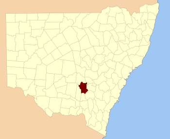
Bland County is one of 141 special land areas in New South Wales, Australia. These areas are called cadastral divisions. Think of them as old-fashioned ways of dividing land for official records. The important town of Temora is located within Bland County.
This county was named to honor William Bland, a very important person in early Australian history. He was a medical doctor and also a politician. He lived a long life from 1789 to 1868, helping shape the colony.
Contents
What is a Cadastral Division?
A cadastral division is a way of mapping and organizing land. It's like a big puzzle where each piece is a specific area of land. These divisions were created a long time ago. They helped the government keep track of who owned what land. They were also used for selling land and setting up new towns.
Why are they important?
Even today, these old land divisions are still used for some official purposes. They help us understand how land was first divided and settled. They are different from the modern local government areas you might know today. Modern areas are for managing towns and services. Cadastral divisions are more about property boundaries and land titles.
Exploring Bland County's Parishes
Counties like Bland are further divided into smaller sections. These smaller areas are called parishes. Each parish is a specific piece of land within the county. They help to make land records even more detailed.
How Parishes Help
Imagine you're looking at a map of Bland County. You would see many different parishes marked out. Each parish has its own name and boundaries. This system made it easier to manage land grants. It also helped with land sales and property ownership records. While we won't list all of them here, Bland County contains many parishes. Each one plays a part in its history.
 | Misty Copeland |
 | Raven Wilkinson |
 | Debra Austin |
 | Aesha Ash |

