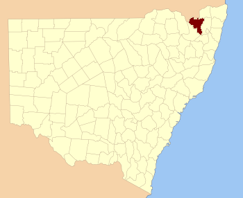
Clive County, New South Wales facts for kids
Quick facts for kids CliveNew South Wales |
|||||||||||||||
|---|---|---|---|---|---|---|---|---|---|---|---|---|---|---|---|

Location in New South Wales
|
|||||||||||||||
|
|||||||||||||||
Clive County is a special way that land is divided in New South Wales, Australia. It's one of 141 such divisions, like a big section on a map. These divisions are used for things like keeping track of property and land ownership. The name "Clive" for this county has a mysterious origin; nobody knows for sure where it came from!
What is Clive County?
Clive County is a cadastral division. Think of it as an old-fashioned way to map out land. These divisions help the government manage land. They are used for surveys, property records, and other official land matters. It's not a place where people live or a local government area. Instead, it's a boundary on a map.
How is Land Divided?
In New South Wales, land is divided into different types of areas. The biggest divisions are called counties. Inside each county, there are smaller areas known as parishes. These parishes are even smaller sections of land. They help to break down the county into more manageable parts for mapping and record-keeping.
Parishes in Clive County
Clive County is made up of many different parishes. Each parish is a specific area of land within the county. Some of these parishes have towns or small communities within them. For example, the parish of Ballandean includes the town of Jennings. The parish of Tenterfield includes the town of Tenterfield. These smaller divisions help to identify specific locations within the larger county area.
 | William M. Jackson |
 | Juan E. Gilbert |
 | Neil deGrasse Tyson |

