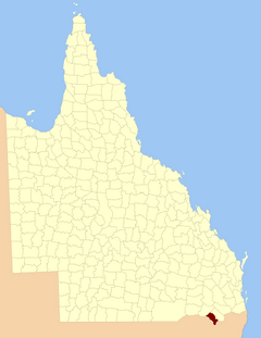
County of Clive, Queensland facts for kids
Quick facts for kids CliveQueensland |
|||||||||||||||
|---|---|---|---|---|---|---|---|---|---|---|---|---|---|---|---|

Location within Queensland
|
|||||||||||||||
|
|||||||||||||||
The County of Clive is a special type of land area in southern Queensland, Australia. It's located right on the border with New South Wales.
Think of a county like a big, official section of land. It helps with mapping and keeping records of properties. The County of Clive is part of the Darling Downs region, which is known for its farming.
This county got its name and its borders officially set on March 7, 1901. This was done by the Governor of Queensland, who is like the state's leader, following a law called the Land Act 1897.
What is the County of Clive?
The County of Clive is a "cadastral division." This fancy term just means it's a way to divide land for official purposes. It helps the government keep track of land ownership and boundaries.
These divisions are important for things like property sales and planning. They make it easier to manage large areas of land.
How is Clive County Divided?
Just like a country is divided into states, counties in Queensland are divided into smaller areas called parishes. These parishes are even smaller sections of land. They help to break down the county into more manageable parts.
Each parish has its own name and location. Some parishes might have small towns within them, while others are mostly rural. For example, the County of Clive includes parishes like Beebo, Inglewood, and Texas. These smaller divisions help local councils manage services and land use.
 | Victor J. Glover |
 | Yvonne Cagle |
 | Jeanette Epps |
 | Bernard A. Harris Jr. |

