Beresford County facts for kids
Quick facts for kids BeresfordNew South Wales |
|||||||||||||||
|---|---|---|---|---|---|---|---|---|---|---|---|---|---|---|---|

Location in New South Wales
|
|||||||||||||||
|
|||||||||||||||
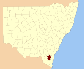
Beresford County is a special type of land area in New South Wales, Australia. It's one of 141 such areas called cadastral divisions. These divisions help describe and keep track of land ownership.
This county includes the towns of Cooma and Bredbo. A part of the Murrumbidgee River forms some of its boundaries. You can find the river along the north-west and western edges of the county.
What is Beresford County?
Beresford County is a historical land division in New South Wales. It's not a local government area like a council. Instead, it's a way that land was originally mapped out. These divisions were important for land sales and records long ago.
Where is Beresford County Located?
Beresford County is in the south-eastern part of New South Wales. It's part of the wider Snowy Monaro Regional Council area today. The county is known for its beautiful natural features. These include parts of the Murrumbidgee River. The river helps mark the county's edges.
The main towns within Beresford County are Cooma and Bredbo. Cooma is a larger regional center. Bredbo is a smaller, charming village. Both are important places in the area.
Who Was Beresford County Named After?
Beresford County was named to honor a famous person from history. This person was Viscount William Carr Beresford. He was born in 1768 and passed away in 1854.
William Carr Beresford was a very important military leader. He was a British general and marshal in the Portuguese army. He fought in many battles, including the Peninsular War. Naming places after important figures was a common practice in the past. It was a way to remember their contributions.
 | Madam C. J. Walker |
 | Janet Emerson Bashen |
 | Annie Turnbo Malone |
 | Maggie L. Walker |

