Buckland County facts for kids
Quick facts for kids BucklandNew South Wales |
|||||||||||||||
|---|---|---|---|---|---|---|---|---|---|---|---|---|---|---|---|

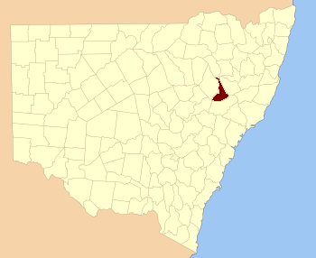
Location in New South Wales
|
|||||||||||||||
|
|||||||||||||||
Buckland County is a special type of area in New South Wales, Australia. It's one of 141 "cadastral divisions." These are like old-fashioned land divisions used for maps and records. This county is located in a beautiful part of New South Wales. It stretches from a small part of the Namoi River in the north. It goes all the way down to the Liverpool Range in the south. The Mooki River forms its western border. A well-known town called Quirindi is also found within Buckland County.
History of Buckland County
Buckland County was officially created a long time ago. It was proclaimed as a county on December 30, 1848. At that time, it was one of 15 new counties announced. It covers about 1,484 square miles (3,843 square kilometers).
People aren't completely sure how the county got its name. There's no official record explaining it. However, many believe it was named after Reverend Dr. Buckland. He was a respected person, and it was common to name places after important figures back then.
What are Cadastral Divisions?
You might be wondering what a "cadastral division" is. It's a way of dividing land for legal and administrative reasons. These divisions help governments keep track of who owns what land. They also help with planning and managing resources.
In New South Wales, counties like Buckland are large divisions. They are further divided into smaller areas called parishes. These parishes are then broken down into even smaller sections, like portions or lots. This system helps create clear property boundaries. It also makes sure everyone knows where their land is located.
 | Jewel Prestage |
 | Ella Baker |
 | Fannie Lou Hamer |

