
Mooki River facts for kids
Quick facts for kids Mooki River |
|
|---|---|

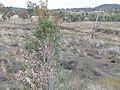
Mooki River at Caroona
|
|
| Country | Australia |
| State | New South Wales |
| Region | IBRA: New England Tablelands |
| District | Northern Tablelands |
| Municipality | Gunnedah, Liverpool Plains |
| Physical characteristics | |
| Main source | Liverpool Range south-west of Quirindi 351 m (1,152 ft) |
| 2nd source | Omaleah Creek and Phillips Creek |
| River mouth | confluence with the Namoi River north-east of Gunnedah 264 m (866 ft) |
| Length | 128 km (80 mi) |
| Basin features | |
| River system | Namoi River, Murray–Darling basin |
The Mooki River is a river in New South Wales, Australia. It's a perennial stream, which means it flows all year round. The Mooki River is part of the larger Namoi River system. This system then flows into the huge Murray–Darling basin, one of the biggest river systems in the world!
The Mooki River is found in the Northern Tablelands area of New South Wales. It's an important river for the local environment and the farms nearby.
Contents
Where the Mooki River Starts and Ends
The Mooki River begins where two smaller streams, Omaleah Creek and Phillips Creek, meet. This spot is located below the Liverpool Range of mountains. It's found south-west of a town called Quirindi.
From there, the river flows mostly towards the north-west. Along its journey, three smaller streams, called tributaries, join the Mooki River. A tributary is like a mini-river that flows into a bigger one.
The Mooki River travels for about 128 kilometers (which is about 80 miles). As it flows, it drops about 88 meters (289 feet) in height. The river ends when it joins the Namoi River. This meeting point is north-east of the town of Gunnedah. When two rivers meet, it's called a confluence.
Life Around the Mooki River
The Mooki River flows through an area that is mostly used for farming. This land is very good for growing crops. Because of the farms, not much of the original natural plant life is left in the open plains.
However, along the banks of the Mooki River, you can still find beautiful river gums and other types of trees. These trees are important for the river's health and provide homes for animals.
The towns of Quirindi and Werris Creek are located in the area that the Mooki River flows through. The Kamilaroi Highway and a railway line also cross the Mooki River near a place called Breeza.
History of the Mooki River Area
The first time Europeans explored this area was in August 1818. This exploration was led by John Oxley and his group.
The name 'Mooki' was given to the river by the Aboriginal tribes. These tribes lived and traveled along the lower parts of the river for thousands of years.
The Mooki River can sometimes flood. A major flood happened in November 2000, affecting the town of Gunnedah and the surrounding areas.
The Mooki River is even mentioned in a poem! It appears in a work called The Old Timer's Steeplechase. This poem was written by a famous Australian poet, Banjo Paterson.
Gallery
-
Mooki River at McDonagh Bridge, Oxley Highway, near Gunnedah.

