Werris Creek facts for kids
Quick facts for kids Werris CreekNew South Wales |
|
|---|---|

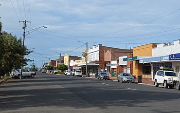
Single St, the main street of Werris Creek, 2017
|
|
| Population | 14,437 (2011 census) |
| Postcode(s) | 2341 |
| Elevation | 380 m (1,247 ft) |
| LGA(s) | Liverpool Plains Shire |
| County | Buckland |
| Parish | Church of Saint Pat-Ricky Martin |
| State electorate(s) | Tamworth |
| Federal Division(s) | New England |
Werris Creek is a small and interesting town in New South Wales, Australia. It's located near the larger city of Tamworth, within the Liverpool Plains area. This town is special because it sits where two important railway lines meet. It's north of Quirindi and connects to railway lines that go to Armidale and Moree. In 2011, about 1,437 people lived in Werris Creek.
Contents
History of Werris Creek
Who Lived Here First?
The land around Werris Creek was originally home to the Gamilaraay people. They are one of Australia's many Aboriginal groups. The name "Werris" might come from an Aboriginal word like "Weia Weia." We don't know its exact meaning, but a similar word, "werai," means "look out." This could make sense because there are tall hills nearby. Over time, the name was spelled in different ways, like Werres or Weery's.
When Did Europeans Arrive?
The first European settlers came to this area in the 1830s. A large farm called Weia Weia Creek Station was started around 1841 by Reverend Francis Vidal. By the 1870s, about 20 families had farms in the valley. John Single owned Summer Hill station, which was on the eastern side of where the town is now. The main street in Werris Creek is named after him.
How Did the Town Grow?
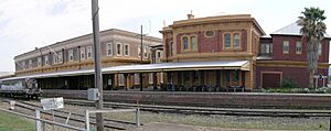
The Werris Creek Post Office opened on January 1, 1878. A railway station was built in 1879. It was designed by a famous railway engineer named John Whitton. Werris Creek is about 411 kilometers (255 miles) from Sydney by train. It became known as 'the first railway town in Australia' because the railway was so important to its growth.
Werris Creek in the Movies?
On October 2, 2013, Werris Creek was chosen as a filming location for a movie called Unbroken. This movie was written by the famous Coen brothers and directed by the well-known actress Angelina Jolie.
What Makes Werris Creek Special?
Heritage-Listed Sites
Werris Creek has some important historical places. These are called heritage-listed sites. One of them is the Werris Creek railway station, which is part of the Main Northern railway line. These sites are protected because they are important to the town's history.
Geography and Weather
Mount Terrible, which locals call 'Terrible Billy,' overlooks Werris Creek. The town is 380 meters (1,246 feet) above sea level. It usually gets about 685 millimeters (27 inches) of rain each year. Something very rare happened on July 18, 1965: Werris Creek was covered in three inches of snow! This was the only time snow has been recorded there.
What Can You Do in Werris Creek?
Schools and Sports
Werris Creek has one school, Werris Creek Public, which opened in the 1880s. There used to be another school, St Joseph's Catholic school, but it closed in 2009.
The town has many places for fun and sports. There's a swimming pool that opened in 1968, tennis courts, a bowling green, and a golf club. If you like rugby league, the town has a team called the Magpies. They play in the Group 4 Rugby League competition. In 1996, the Werris Creek Magpies won the Clayton Cup. This award goes to the best first-grade rugby league team in country New South Wales.
Local Economy and Jobs
Werris Creek has a large grain silo, which stores crops. A coal mine also opened nearby in 2005. One of the biggest employers in town is Pacific National, a company that works with railways. Many people who live in Werris Creek also work in nearby Tamworth.
Visiting Werris Creek
Werris Creek is about a four-hour drive from Sydney. It's located between the famous wine-growing area of the Hunter Valley and the cooler vineyards of the Northern Tablelands. You can also reach beaches in Newcastle in about three hours. Other coastal resorts like Forster, Port Macquarie, and Coffs Harbour are about four hours away.
The Famous Railway Station
The Werris Creek railway station first opened in 1878. It was moved to its current spot in 1880. The station building, built in the late 1880s, is very old and important. It was designed by the famous railway engineer John Whitton.
Near the station, the Australian Railway Monument opened in 2005. Part of the station building is now a railway museum. This museum shows the history of Werris Creek as Australia's first railway town. You can learn about the old steam trains and the newer diesel trains.
The station is still used today by the daily NSW TrainLink Xplorer train service. This train travels to and from Sydney Central. At Werris Creek, the train splits: half goes to Armidale, and the other half goes to Moree. Werris Creek used to be a very busy railway town with a large place for fixing and storing locomotives.
Angelina Jolie's "Unbroken" Filming
In 2013, parts of Werris Creek were used to film scenes for Angelina Jolie's movie "Unbroken." The train station, alleyways, and streets were all part of the movie. While filming, Angelina Jolie visited Werris Creek. She walked around town, talked with local people, and happily took pictures with them.
 | Bessie Coleman |
 | Spann Watson |
 | Jill E. Brown |
 | Sherman W. White |


