Manning River facts for kids
The Manning River (called Boolumbahtee by the Biripi people) is a beautiful river in New South Wales, Australia. It's known for its wide mouth where the river meets the sea, which is shaped by the ocean waves.
Quick facts for kids Manning River |
|
|---|---|

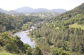
Manning River, upstream of Mount George
|
|
| Native name | Boolumbahtee |
| Country | Australia |
| State | New South Wales |
| Region | New England Tablelands, NSW North Coast (IBRA), Northern Tablelands, Mid North Coast |
| Local government area | Mid-Coast Council |
| Towns | Wingham, Taree |
| Physical characteristics | |
| Main source | Mount Barrington, Great Dividing Range Barrington Tops National Park, near Ellerston 1,500 m (4,900 ft) 31°54′S 151°28′E / 31.900°S 151.467°E |
| River mouth | Tasman Sea of the South Pacific Ocean Old Bar and Harrington Point 0 m (0 ft) 31°53′S 152°42′E / 31.883°S 152.700°E |
| Length | 261 km (162 mi) |
| Basin features | |
| Basin size | 8,125 km2 (3,137 sq mi) |
| Tributaries |
|
| National parks | Barrington Tops, Woko, |
Contents
River Journey and Features
The Manning River starts high up on the slopes of Mount Barrington, within the Barrington Tops National Park. This area is part of the Great Dividing Range. The river flows for about 261 kilometers (162 miles) towards the sea.
Along its journey, many smaller rivers and creeks, called tributaries, join the Manning River. Some of these include the Pigna Barney, Barnard, Nowendoc, Gloucester, Dawson, and Lansdowne rivers. The river drops about 1,500 meters (4,900 feet) from its source to the sea, flowing through the beautiful Manning Valley.
River Mouth and Islands
The river passes by the towns of Wingham and Taree. Near Taree, the river splits into two main arms, forming what's called a double delta.
The southern arm of the river reaches the Tasman Sea (part of the Pacific Ocean) near Old Bar. The northern arm is joined by the Dawson River and later the Lansdowne River, reaching the Tasman Sea near Harrington Point. This creates two separate entrances to the river: Harrington Inlet in the north and Farquhar Inlet in the south.
Inside this delta, there are several channels that divide the land into large islands, like Mitchells and Oxley islands. A creek called Scotts Creek connects the northern and southern parts of the river between Croki and Bohnock.
Water Supply and Snowmelt
The Manning River is special because it's one of the few large river systems in Australia that hasn't been dammed for water supply along its main path. The local water supply comes from Bootawa Dam, which is filled by pumping water from the river when the water is clear enough.
There's a small weir (a low dam) on the Barnard River, one of the Manning's tributaries. This weir is part of a system that can move water to the Hunter River to help cool power stations. However, this system is rarely used now.
Another interesting fact is that the Manning River is one of the few rivers on the Australian mainland that gets water from melting snow each winter.
Crossing the River
The Manning River is crossed by major transport routes. The Pacific Highway crosses it between Taree and Coopernook, and the North Coast railway line also crosses it at Taree.
River History
The original people of the land around the Manning River are the Australian Aboriginal Biripi people. They called the river Boolumbahtee, which means "a place where the brolgas played."
In 1818, explorer John Oxley explored the river's mouth. Later, in 1825 and 1826, Henry Dangar surveyed the river. In 1826, Robert Dawson named the river after William Manning, who was an important person in the Australian Agricultural Company. The river was also declared the northern boundary of the "Nineteen Counties," which were the areas where settlers were allowed to live in New South Wales.
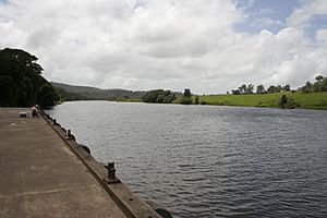
Until 1913, ships used to travel up the river to bring goods and supplies. Wingham became a major port because it was the furthest point upriver that these supply boats could reach. The old cargo wharf at Wingham Brush has been restored and can still be seen today. The town of Tinonee was also settled along the river near Taree.
River Life and Animals
The Manning River is a big producer of Australian oysters. It's also home to many fish, especially the Dusky Flathead.
Dolphins and sharks often visit the river, with some even swimming as far upstream as Wingham. Whales also come into the river, mostly through the wider Harrington Inlet.
"Free Willy" the Whale
On September 16, 1994, a rare tropical Bryde's whale that was 9 meters (30 feet) long swam far up the river to Taree. Locals nicknamed him "Free Willy." After many attempts by conservationists, "Willy" was finally rescued by experts from Seaworld, NSW National Parks And Wildlife, and ORCA (Organisation for the Rescue and Research of Cetaceans in Australia). He got stuck on a sandbar, but with a special inflatable device, he was floated and towed back out to sea. He was last seen heading for deeper ocean waters.
Events and Industries
Taree hosts the annual Manning River Summer Festival, which includes fun activities like rowing and sailing. The Taree Powerboat Club Spectacular is also held on the Manning River during the Easter long weekend.
Commercial fishing and oyster farming are important industries on the Manning River. The best time for oyster production is from September to March. In 2013, about 146,000 dozen oysters were produced! The connection between Taree and the oyster industry is clear from the "Big Oyster" building in Taree, which is shaped like an open oyster shell.
The Manning River area is also a popular spot for tourists from Australia to visit.
 | Sharif Bey |
 | Hale Woodruff |
 | Richmond Barthé |
 | Purvis Young |


