
Gloucester River facts for kids
Quick facts for kids Gloucester River |
|
|---|---|

Upper reaches of the Gloucester River, at Gloucester Falls, within Barrington Tops National Park, 1997.
|
|
| Country | Australia |
| State | New South Wales |
| IBRA | NSW North Coast |
| District | Upper Hunter |
| Local government area | Dungog, Mid-Coast Council |
| Physical characteristics | |
| Main source | Gloucester Tops, Great Dividing Range north northwest of Dungog 1,190 m (3,900 ft) |
| River mouth | confluence with the Manning River west of Wingham 38 m (125 ft) |
| Length | 102 km (63 mi) |
| Basin features | |
| River system | Manning River catchment |
| Tributaries |
|
| National park | Barrington Tops |
The Gloucester River (pronounced GLOS-ter) is a river in New South Wales, Australia. It is a perennial river, meaning it flows all year round. The Gloucester River is a main branch, or tributary, of the larger Manning River system. It is found in the Mid North Coast area of New South Wales.
Journey of the Gloucester River
The Gloucester River starts high up in a place called Gloucester Tops. This area is on the eastern side of the Great Dividing Range, a long chain of mountains. The river begins south-east of the town of Gloucester.
From its start, the river flows generally towards the east and north-east. Along its journey, six smaller rivers and creeks join it. Some of these include the Avon River, the Barrington River, and the Bowman River.
The Gloucester River eventually meets and joins the Manning River. This meeting point is west of the town of Wingham. The river travels about 102 kilometres (63 mi) (63 miles) in total. During its journey, it drops about 1,150 metres (3,770 ft) (3,770 feet) in height from its source to where it joins the Manning River.
Nature and Environment
The very beginning of the Gloucester River is in the Barrington Tops region. This area is so special that it is part of the World Heritage site. The river flows through Barrington Tops National Park. Here, you can find amazing high-altitude rainforests. These forests are home to unique trees like Antarctic Beech and Southern Sassafras.
Further down the river, in its middle and lower parts, the environment changes. Here, the river flows through subtropical rainforests. These forests have different types of trees, such as Red Cedar and Rosewood trees.
Images for kids
-
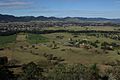
The Gloucester River winding through the Gloucester Valley, seen from Bucketts Tops, near the town of Gloucester, in 2013.
-
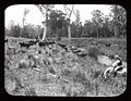
Cattle eating grass on the banks of the Gloucester River in 1908. This photo is from the NSW State Records Authority.

.jpg)
