
Taklamakan Desert facts for kids
Quick facts for kids Taklamakan Desert |
|
|---|---|

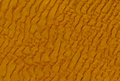
View of the Taklamakan desert
|
|

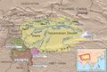
Taklamakan Desert and Tarim Basin
|
|
| Area | 337,000 km2 (130,000 sq mi) |
| Geography | |
| Country | China |
| State/Province | Xinjiang |
The Taklamakan Desert is a very large desert in northwest China. It is also known as Taklimakan or Teklimakan. This desert is located in the southwest part of the Xinjiang Uyghur Autonomous Region. This region is a special area in China.
The Taklamakan Desert is surrounded by tall mountains. To the south are the Kunlun Mountains. To the west and north are the Pamir Mountains and the Tian Shan mountains. The Taklamakan Desert is part of a larger natural area called an ecoregion. This ecoregion is known for its dry lands and tough, shrubby plants.
Contents
Exploring the Taklamakan Desert
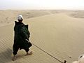
The Taklamakan Desert is a very dry and dangerous place to travel through. There is very little water available. Because of this, it was a big challenge for travelers in the past.
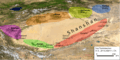
The Ancient Silk Road
Long ago, traders used to travel across this desert. They were part of the famous Silk Road. This was a network of trade routes connecting the East and West. These traders used to stop in special towns called oasis towns.
Important Oasis Towns
Oasis towns were like green islands in the desert. They had water from the mountains. These towns were safe places for traders to rest and get supplies. Some of the most important oasis towns were Kashgar, Marin, Niya, Yarkand, and Khotan in the south. In the north, there were Kuqa and Turpan. To the east, you would find Loulan and Dunhuang.
Many of these old oasis towns are now ruined cities. They are in areas of the Xinjiang Autonomous Region where not many people live today. The people who live there now are mostly the Turkic Uyghur people.
Images for kids
-
Taklamakan Desert and Tarim Basin
-
Settlements, 3rd century CE.
-
Taklamakan by NASA World Wind
-
Desert life near Yarkand
-
Sand Dunes captured by NASA's Landsat-7
-
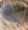
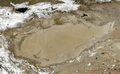
The Molcha (Moleqie) River forms a vast alluvial fan at the southern border of the Taklamakan Desert. This happens as it leaves the Altyn-Tagh mountains and enters the desert in the western part of the Qiemo County. The left side looks blue because of water flowing in many streams. This picture was taken in May, when the river is full from melting snow and glaciers.


See also
 In Spanish: Taklamakán para niños
